 |
|
| Napaskiak Airport |
 |
| IATA: PKA – ICAO: PAPK – FAA LID: PKA |
| Summary |
| Airport type |
Public |
| Owner |
State of Alaska DOT&PF - Central Region |
| Serves |
Napaskiak, Alaska |
| Elevation AMSL |
24 ft / 7 m |
| Coordinates |
60°42′10″N 161°46′42″W / 60.70278°N 161.77833°W / 60.70278; -161.77833 |
| Runways |
| Direction |
Length |
Surface |
| ft |
m |
| 2/20 |
3,000 |
914 |
Gravel |
| 9W/27W |
15,000 |
4,572 |
Water |
| Statistics |
| Enplanements (2008) |
1,321 |
| Source: Federal Aviation Administration |
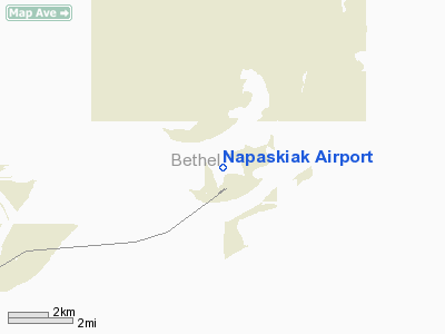
Napaskiak Airport (IATA: PKA, ICAO: PAPK, FAA LID: PKA) is a state-owned, public-use airport located one nautical mile (1.85 km) southwest of the central business district of Napaskiak, a city in the Bethel Census Area of the U.S. state of Alaska.
As per Federal Aviation Administration records, Napaskiak Airport had 1,321 passenger boardings (enplanements) in calendar year 2008, a decrease of 28.9% from the 1,858 enplanements in 2007. This airport is included in the FAA's National Plan of Integrated Airport Systems (2009-2013), which categorizes it as a general aviation facility.
Facilities
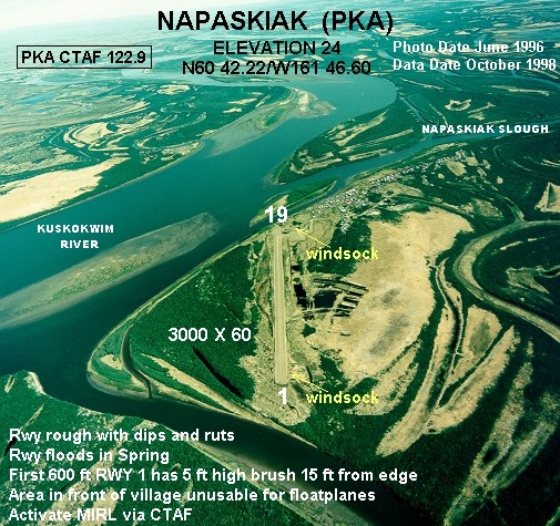
Napaskiak Airport has one runway designated 2/20 with a gravel surface measuring 3,000 by 60 feet (914 x 18 m). It also has a seaplane waterway on the Kuskokwim River which is designated 9W/27W and measures 15,000 by 2,000 feet (4,572 x 610 m). The airport is unattended.
The above content comes from Wikipedia and is published under free licenses – click here to read more.
Location
& QuickFacts
|
FAA
Information Effective: |
2006-02-16 |
|
Airport
Identifier: |
PKA |
|
Longitude/Latitude: |
161-46-41.9000W/60-42-10.5000N
-161.778306/60.702917 (Estimated) |
|
Elevation: |
24 ft / 7.32 m (Surveyed) |
|
Land: |
0 acres |
|
From
nearest city: |
1 nautical miles SW of Napaskiak, AK |
|
Location: |
Bethel County, AK |
|
Magnetic Variation: |
15E (2005) |
Owner
& Manager
|
Ownership: |
Publicly owned |
|
Owner: |
State Of Ak Dotpf/ce Region |
|
Address: |
Po Box 196900
Anchorage, AK 99519-6900 |
|
Phone
number: |
907-269-0747 |
|
Manager: |
L.j. Davis |
|
Address: |
Box 505
Bethel, AK 99559 |
|
Phone number: |
907-543-2495 |
Airport
Operations and Facilities
|
Airport
Use: |
Open to public |
|
Wind
indicator: |
Yes
WINDSOCK MAY BE UNRELIABLE. |
|
Segmented
Circle: |
Yes |
|
Control
Tower: |
No |
|
Attendance
Schedule: |
UNATNDD |
|
Lighting
Schedule: |
DUSK-DAWN
ACTVT MIRL RY 02/20 - CTAF. |
|
Beacon
Color: |
Clear-Green (lighted land airport) |
|
Landing
fee charge: |
No |
|
Sectional
chart: |
Bethel |
|
Region: |
AAL - Alaska |
|
Boundary
ARTCC: |
ZAN - Anchorage |
|
Tie-in
FSS: |
ENA - Kenai |
|
FSS
on Airport: |
No |
|
FSS
Phone: |
800-478-3576 |
|
FSS
Toll Free: |
1-800-WX-BRIEF |
|
NOTAMs
Facility: |
BET (NOTAM-d service avaliable) |
|
Federal Agreements: |
NGY |
Airport
Communications
Airport
Services
|
Airframe
Repair: |
NONE |
|
Power
Plant Repair: |
NONE |
|
Bottled
Oxygen: |
NONE |
|
Bulk
Oxygen: |
NONE |
|
Runway Information
Runway 02/20
|
Dimension: |
3000 x 60 ft / 914.4 x 18.3 m |
|
Surface: |
GRVL, Good Condition |
|
Edge
Lights: |
Medium |
|
|
Runway 02 |
Runway 20 |
|
Longitude: |
161-46-57.3190W |
161-46-26.4950W |
|
Latitude: |
60-41-57.7900N |
60-42-23.1780N |
|
Elevation: |
12.00 ft |
12.00 ft |
|
Alignment: |
31 |
127 |
|
Traffic
Pattern: |
Left |
Left |
|
Obstruction: |
, 50:1 slope to clear |
30 ft brush, 800.0 ft from runway, 20 ft left
of centerline, 26:1 slope to clear |
|
Runway 09W/27W
|
Dimension: |
15000 x 2000 ft / 4572.0 x 609.6 m |
|
Surface: |
WATER, |
|
|
Runway 09W |
Runway 27W |
|
Elevation: |
10.00 ft |
10.00 ft |
|
Traffic
Pattern: |
Left |
Left |
|
Radio Navigation
Aids
|
ID |
Type |
Name |
Ch |
Freq |
Var |
Dist |
|
ET |
NDB |
Bethel |
|
344.00 |
19E |
5.8 nm |
|
OSE |
NDB |
Oscarville |
|
251.00 |
19E |
6.0 nm |
|
BET |
VORTAC |
Bethel |
088X |
114.10 |
19E |
5.1 nm |
Remarks
- WATCH
FOR NETS & BOATS IN RIVER; AREA IN FRONT OF VILLAGE UNUSABLE FOR
FLOAT PLANES.
- RWY
02/20 FLOODS IN SPRING.
- RY
02/20 CONDITION NOT MONITORED; RECOMMEND VISUAL INSPECTION PRIOR TO
USE.
- PILOTS
ARE REQUESTED TO SELF-ANNOUNCE ON CTAF PRIOR TO TAXIING ON RWY FOR DEPARTURE;
LEAVING THE RWY AND WITHIN 10 NM OF THE ARPT WHEN APPROACHING TO LAND.
- BARGE
LDG SITE NORTH END OF RY. MACHINERY AND LARGE SUPPLIES MAY BE STORED
IN AREA.
- SPB
ASP: ESTABD PRIOR TO 1959.
Based Aircraft
|
Aircraft
based on field: |
1 |
|
Single
Engine Airplanes: |
1 |
Napaskiak Airport
Address:
Bethel County, AK
Tel:
907-269-0747,
907-543-2495
Images
and information placed above are from
http://www.airport-data.com/airport/PKA/
We
thank them for the data!
| General
Info |
| Country |
United
States |
| State |
ALASKA
|
| FAA ID |
PKA
|
| Latitude |
60-42-10.500N
|
| Longitude |
161-46-41.900W
|
| Elevation |
24 feet
|
| Near City |
NAPASKIAK
|
We don't guarantee the information is fresh and accurate. The data may
be wrong or outdated.
For more up-to-date information please refer to other sources.
|
|


