|
|
| Napakiak Airport |
 |
| IATA: WNA – ICAO: PANA – FAA LID: WNA |
| Summary |
| Airport type |
Public |
| Owner |
State of Alaska DOT&PF - Central Region |
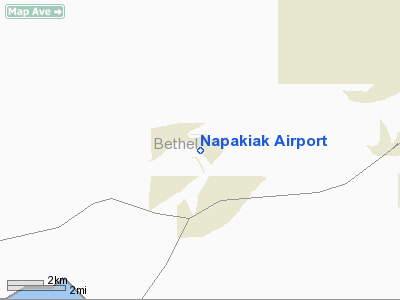
| Serves |
Napakiak, Alaska |
| Elevation AMSL |
17 ft / 5 m |
| Coordinates |
60°41′25″N 161°58′43″W / 60.69028°N 161.97861°W / 60.69028; -161.97861 |
| Runways |
| Direction |
Length |
Surface |
| ft |
m |
| 16/34 |
3,248 |
990 |
Gravel |
| Statistics |
| Enplanements (2008) |
1,840 |
| Source: Federal Aviation Administration |
Napakiak Airport (IATA: WNA, ICAO: PANA, FAA LID: WNA) is a state-owned, public-use airport located in Napakiak, a city in the Bethel Census Area of the U.S. state of Alaska.
As per Federal Aviation Administration records, Napakiak Airport had 1,840 passenger boardings (enplanements) in calendar year 2008, an increase of 0.7% from the 1,828 enplanements in 2007. Napakiak Airport is included in the FAA's National Plan of Integrated Airport Systems (2009-2013), which categorizes it as a general aviation facility.
Facilities
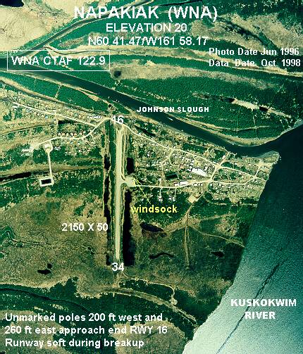
Napakiak Airport has one runway designated 16/34 with a gravel surface measuring 3,248 by 60 feet (990 x 18 m). The airport is unattended.
Remarks:
- Runway 16/34 south 1500-feet 6-inch dips.
- Activate rotating beacon - CTAF
- Activate MIRL runway 16/34, REIL runways 16 & 34 - CTAF.
- Seaplane Base operated in river; Johnson Slough unusable.
- Runway condition not monitored; recommend visual inspection prior to using.
- Windsock unreliable.
- Weather camera available on internet at http://akweathercams.faa.gov
- This airport has been surveyed by the National Geodetic Survey.
- Seaplane Base ASP: established prior to 1959.
The above content comes from Wikipedia and is published under free licenses – click here to read more.
Location
& QuickFacts
|
FAA
Information Effective: |
2006-02-16 |
|
Airport
Identifier: |
WNA |
|
Longitude/Latitude: |
161-58-42.6000W/60-41-25.2000N
-161.978500/60.690333 (Estimated) |
|
Elevation: |
20 ft / 6.10 m (Estimated) |
|
Land: |
0 acres |
|
From
nearest city: |
0 nautical miles W of Napakiak, AK |
|
Location: |
Bethel County, AK |
|
Magnetic
Variation: |
18E (1985) |
Owner
& Manager
|
Ownership: |
Publicly owned |
|
Owner: |
State Of Ak Dot/pf Centrl Reg |
|
Address: |
Po Box 196900
Anchorage, AK 99519-6900 |
|
Phone
number: |
907-266-1735 |
|
Manager: |
L.j. Davis |
|
Address: |
Po Box 505
Bethel, AK 99559 |
|
Phone
number: |
907-543-2495 |
Airport
Operations and Facilities
|
Airport
Use: |
Open to public |
|
Wind
indicator: |
Yes
WINDSOCK MAY BE UNRELIABLE. |
|
Segmented
Circle: |
Yes |
|
Control
Tower: |
No |
|
Attendance
Schedule: |
UNATNDD |
|
Lighting
Schedule: |
RDO-CTL
ACTVT ROTG BCN - CTAF |
|
Beacon
Color: |
Clear-Green (lighted land airport) |
|
Landing
fee charge: |
No |
|
Sectional
chart: |
Bethel |
|
Region: |
AAL - Alaska |
|
Boundary
ARTCC: |
ZAN - Anchorage |
|
Tie-in
FSS: |
ENA - Kenai |
|
FSS
on Airport: |
No |
|
FSS
Phone: |
800-478-3576 |
|
FSS
Toll Free: |
1-800-WX-BRIEF |
|
NOTAMs
Facility: |
BET (NOTAM-d service avaliable) |
|
Federal
Agreements: |
N |
Airport
Communications
Airport
Services
|
Airframe
Repair: |
NONE |
|
Power
Plant Repair: |
NONE |
|
Bottled
Oxygen: |
NONE |
|
Bulk
Oxygen: |
NONE |
|
Runway Information
Runway 16/34
|
Dimension: |
3269 x 60 ft / 996.4 x 18.3 m |
|
Surface: |
GRAVEL, Fair Condition
RWY 16/34 SOUTH 1500 FT 6 IN DIPS. |
|
Edge
Lights: |
Medium |
|
|
Runway 16 |
Runway 34 |
|
Longitude: |
161-58-45.0893W |
161-58-40.0606W |
|
Latitude: |
60-41-41.2406N |
60-41-09.1465N |
|
Elevation: |
13.00 ft |
13.00 ft |
|
Alignment: |
127 |
127 |
|
Traffic
Pattern: |
Left |
Left |
|
Obstruction: |
10 ft brush, 390.0 ft from runway, 39:1 slope
to clear |
8 ft brush, 393.0 ft from runway, 50 ft left of
centerline, 49:1 slope to clear |
|
Radio Navigation
Aids
|
ID |
Type |
Name |
Ch |
Freq |
Var |
Dist |
|
OSE |
NDB |
Oscarville |
|
251.00 |
19E |
6.8 nm |
|
ET |
NDB |
Bethel |
|
344.00 |
19E |
7.9 nm |
|
BET |
VORTAC |
Bethel |
088X |
114.10 |
19E |
7.3 nm |
Remarks
- SPB
OPER IN RIVER; JOHNSON SLOUGH UNUSABLE.
- CAUTION:
RWY CONDITION NOT MONITORED; RECOMMEND VISUAL INSPECTION PRIOR TO USING.
- SPB
ASP: ESTABD PRIOR TO 1959.
Napakiak Airport
Address: Bethel County, AK
Tel:
907-266-1735, 907-543-2495
Images
and information placed above are from
http://www.airport-data.com/airport/WNA/
We
thank them for the data!
| General
Info |
| Country |
United
States |
| State |
ALASKA
|
| FAA ID |
WNA
|
| Latitude |
60-41-25.200N
|
| Longitude |
161-58-42.600W
|
| Elevation |
20 feet
|
| Near City |
NAPAKIAK
|
We don't guarantee the information is fresh and accurate. The data may
be wrong or outdated.
For more up-to-date information please refer to other sources.
|
|