 |
|
| Naknek Airport |
 |
| IATA: NNK – ICAO: none – FAA LID: 5NK |
| Summary |
| Airport type |
Public |
| Owner |
State of Alaska DOT&PF - Central Region |
| Serves |
Naknek, Alaska |
| Elevation AMSL |
70 ft / 21 m |
| Coordinates |
58°43′58″N 157°01′12″W / 58.73278°N 157.02°W / 58.73278; -157.02 |
| Runways |
| Direction |
Length |
Surface |
| ft |
m |
| 8/26 |
1,950 |
594 |
Gravel |
| 14/32 |
1,850 |
564 |
Gravel |
| 8W/26W |
2,000 |
610 |
Water |
| Statistics (2005) |
| Aircraft operations |
7,700 |
| Based aircraft |
24 |
| Enplanements (2008) |
161 |
| Source: Federal Aviation Administration |
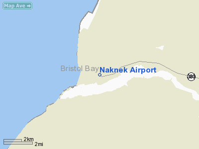
Naknek Airport (IATA: NNK, FAA LID: 5NK) is a state-owned, public-use airport located one nautical mile (1.85 km) north of the central business district of Naknek, in the Bristol Bay Borough of the U.S. state of Alaska.
As per Federal Aviation Administration records, this airport had 161 commercial passenger boardings (enplanements) in calendar year 2008, an increase of 53% from the 105 enplanements in 2007. Naknek Airport is included in the FAA's National Plan of Integrated Airport Systems (2009–2013), which categorizes it as a general aviation facility.
Facilities and aircraft
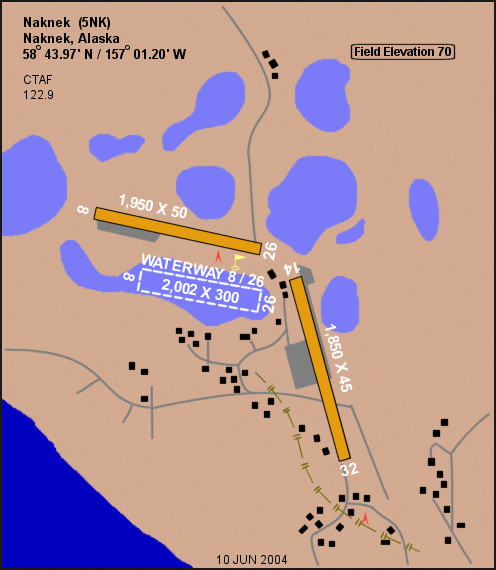
Naknek Airport has three runways with gravel surfaces: 8/26 is 1,950 by 50 feet (594 x 15 m) and 14/32 is 1,850 by 45 feet (564 x 14 m). It also has a seaplane landing area designated 8W/26W which measures 2,000 by 300 feet (610 x 91 m). The waterway is not on the airport property and is not owned or operated by the State of Alaska. The airport is unattended.
For the 12-month period ending December 31, 2005, the airport had 7,700 aircraft operations, an average of 21 per day: 92% general aviation and 8% air taxi. At that time there were 24 aircraft based at this airport: 96% single-engine and 4% helicopter.
The above content comes from Wikipedia and is published under free licenses – click here to read more.
Location
& QuickFacts
|
FAA
Information Effective: |
2006-02-16 |
|
Airport
Identifier: |
5NK |
|
Longitude/Latitude: |
157-01-11.7110W/58-43-58.3700N
-157.019920/58.732881 (Estimated) |
|
Elevation: |
70 ft / 21.34 m (Estimated) |
|
Land: |
0 acres |
|
From
nearest city: |
1 nautical miles N of Naknek, AK |
|
Location: |
Bristol Bay County, AK |
|
Magnetic Variation: |
21E (1985) |
Owner
& Manager
|
Ownership: |
Publicly owned |
|
Owner: |
St Of Ak Dotpf/cen Reg |
|
Address: |
Po Box 196900
Anchorage, AK 99519-6900 |
|
Phone number: |
907-243-1735 |
|
Manager: |
John Fundeen |
|
Address: |
Box 65
King Salmon, AK 99613 |
|
Phone number: |
907-246-3325 |
Airport
Operations and Facilities
|
Airport
Use: |
Open to public |
|
Wind
indicator: |
Yes |
|
Segmented
Circle: |
No |
|
Control
Tower: |
No |
|
Attendance
Schedule: |
UNATNDD |
|
Lighting
Schedule: |
24 HRS
ACTVT MIRL RYS 08/26 & 14/32 - 122.8. |
|
Landing
fee charge: |
No |
|
Sectional
chart: |
Kodiak |
|
Region: |
AAL - Alaska |
|
Boundary
ARTCC: |
ZAN - Anchorage |
|
Tie-in
FSS: |
ENA - Kenai |
|
FSS
on Airport: |
No |
|
FSS
Phone: |
800-478-3576 |
|
FSS
Toll Free: |
1-800-WX-BRIEF |
|
NOTAMs
Facility: |
AKN (NOTAM-d service avaliable) |
|
Federal Agreements: |
N |
Airport
Communications
Airport
Services
|
Fuel
available: |
100LL |
|
Airframe
Repair: |
MAJOR |
|
Power
Plant Repair: |
MINOR |
|
Bottled
Oxygen: |
NONE |
|
Bulk
Oxygen: |
NONE |
|
Runway Information
Runway 08/26
|
Dimension: |
1950 x 50 ft / 594.4 x 15.2 m |
|
Surface: |
GRVL, Good Condition |
|
Edge
Lights: |
Medium |
|
|
Runway 08 |
Runway 26 |
|
Traffic
Pattern: |
Left |
Left |
|
Obstruction: |
, 50:1 slope to clear |
110 ft hill, 4000.0 ft from runway, 36:1 slope
to clear |
|
Runway 08W/26W
|
Dimension: |
2000 x 300 ft / 609.6 x 91.4 m |
|
Surface: |
WATER, |
|
|
Runway 08W |
Runway 26W |
|
Traffic
Pattern: |
Left |
Left |
|
Runway 14/32
|
Dimension: |
1850 x 45 ft / 563.9 x 13.7 m |
|
Surface: |
GRVL, Good Condition |
|
Edge
Lights: |
Medium |
|
|
Runway 14 |
Runway 32 |
|
Traffic
Pattern: |
Left |
Left |
|
Obstruction: |
120 ft hill, 3000.0 ft from runway, 25:1 slope
to clear |
10 ft brush, 200.0 ft from runway, 20:1 slope
to clear |
|
Radio Navigation
Aids
|
ID |
Type |
Name |
Ch |
Freq |
Var |
Dist |
|
AK |
NDB |
Saldo |
|
355.00 |
21E |
7.6 nm |
|
HCP |
NDB |
Kulik Lake |
|
334.00 |
21E |
47.3 nm |
|
AKN |
VORTAC |
King Salmon |
075X |
112.80 |
21E |
8.4 nm |
Remarks
- SEAPLANES
E APCH TO LAKE OVER RWY 14-32 & TIBBETTS ARPT.
- NO
LINE OF SIGHT BETWEEN RUNWAYS OR WATERWAYS.
- FLOAT
ACFT DEPARTING NORTHWEST LAKE TO EAST, CROSS ARPT AT LOW ALTITUDE, ACFT
NOT VISIBLE UNTIL AIRBORNE.
- FIRST
200 FT RY 32 SOFT WHEN WET. FIRST 400 FT RY 32 SLOPES DOWNHILL - 5%
SLOPE.
- UNCONTOLLED
VEHICULAR TFC ON RY.
- CTN:
RWY COND NOT MONITORED; RECOMMEND VISUAL INSPECTION PRIOR TO USING.
- 100LL
ALSO AVBL AT NAKNEK SEAPLANE BASE.
- ACFT
ON EAST SIDE OF RY 14/32 MAY BE IN SAFETY AREA.
- PILOTS
ARE REQUESTED TO SELF-ANNOUNCE ON CTAF PRIOR TO TAXIING ON RWY FOR DEPARTURE;
LEAVING THE RWY AND WITHIN 10 NM OF THE ARPT WHEN APPROACHING TO LAND.
Based Aircraft
|
Aircraft
based on field: |
70 |
|
Single
Engine Airplanes: |
70 |
Operational Statistics
|
Aircraft
Operations: |
149/Week |
|
Air Taxi: |
7.8% |
|
General
Aviation Local: |
90.9% |
|
General
Aviation Itinerant: |
1.3% |
Naknek Airport
Address:
Bristol Bay County, AK
Tel:
907-243-1735, 907-246-3325
Images
and information placed above are from
http://www.airport-data.com/airport/5NK/
We
thank them for the data!
| General
Info |
| Country |
United
States |
| State |
ALASKA
|
| FAA ID |
5NK
|
| Latitude |
58-43-58.370N
|
| Longitude |
157-01-11.711W
|
| Elevation |
70 feet
|
| Near City |
NAKNEK
|
We don't guarantee the information is fresh and accurate. The data may
be wrong or outdated.
For more up-to-date information please refer to other sources.
|
|


