|
|
| Merrill Field |
 |
| IATA: MRI – ICAO: PAMR – FAA LID: MRI |
| Summary |
| Airport type |
Public |
| Owner |
Municipality of Anchorage |
| Location |
Anchorage, Alaska |
| Elevation AMSL |
137 ft / 42 m |
| Coordinates |
61°12′49″N 149°50′40″W / 61.21361°N 149.84444°W / 61.21361; -149.84444 |
| Website |
www.MerrillField.com |
| Runways |
| Direction |
Length |
Surface |
| ft |
m |
| 4/22 |
2,000 |
610 |
Gravel/Dirt |
| 7/25 |
4,000 |
1,219 |
Asphalt |
| 16/34 |
2,640 |
805 |
Asphalt |
| Statistics (2004) |
| Aircraft operations |
191,550 |
| Based aircraft |
966 |
| Source: Federal Aviation Administration |
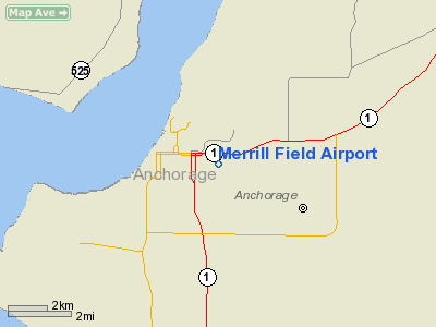
Merrill Field (IATA: MRI, ICAO: PAMR, FAA LID: MRI) is a public-use general aviation airport located one mile (1.6 km) east of downtown Anchorage in the U.S. state of Alaska. The airport is owned by Municipality of Anchorage.
This was the first official airport in Anchorage when it opened in 1930. The airport is named for Russel Merrill, an Alaskan aviation pioneer. The first aviation beacon in the Territory of Alaska was located at Merrill Field and was dedicated on September 25, 1932 in Merrill's honor.
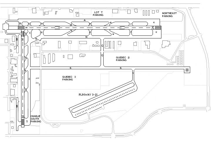
Merrill Field is home to the University of Alaska Anchorage's Aviation Technology Division, as well as many local flight schools, air taxi services, and fixed base operators. An extension of the Q Taxiway connects the airport to Alaska Regional Hospital for MEDEVAC operations.
A section of the airport is built over the closed Merrill Field Land Fill. This section requires slightly more maintenance due to settling and emissions. Facilities and aircraft
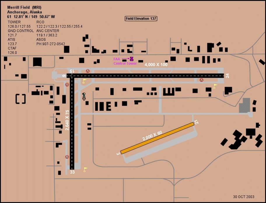
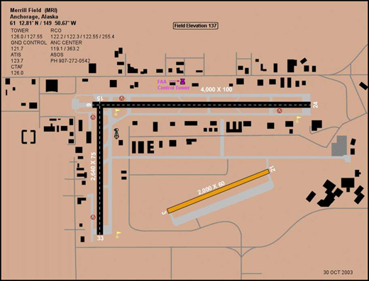
Merrill Field covers 436 acres (176 ha, 1.76 km²) and has three runways:
- Runway 4/22: 2,000 x 60 ft (610 x 18 m), Surface: Gravel/Dirt
- Runway 7/25: 4,000 x 100 ft (1,219 x 30 m), Surface: Asphalt
- Runway 16/34: 2,640 x 75 ft (805 x 23 m), Surface: Asphalt
For 12-month period ending August 5, 2004, the airport had 191,550 aircraft operations, an average of 524 per day, 100% of which were general aviation. There are 966 aircraft based at this airport: 93% single engine, 5% multi-engine, 2% helicopters and <1% gliders.
History
Merrill Field, located on the east end of 5th Avenue in Anchorage, Alaska, was the only airport serving Anchorage until 1951 when the introduction of ever larger and faster commercial aircraft required that an airfield with longer and heavier runways be built.
The airstrip is still in use today as the primary field for private wheel equipped aircraft in the warmer months and for ski equipped in the winter.
The above content comes from Wikipedia and is published under free licenses – click here to read more.
"Only 370 miles South of the Arctic Circle"
MRI (PAMR) -- N61°12.86' by W149° 50.77'
 Merrill
Field was established in 1930 one mile east of downtown
Anchorage on 436 acres. This was the first real airport in Anchorage. The
airport bears the name of Russel Hyde Merrill. Russel Merrill
was an early Alaskan aviation pioneer who disappeared in September 1929
on a flight to Bethel. The first aviation beacon in the Territory of Alaska
was located at Merrill Field and was dedicated on September 25, 1932 to
the honor of Russ Merrill. Merrill
Field was established in 1930 one mile east of downtown
Anchorage on 436 acres. This was the first real airport in Anchorage. The
airport bears the name of Russel Hyde Merrill. Russel Merrill
was an early Alaskan aviation pioneer who disappeared in September 1929
on a flight to Bethel. The first aviation beacon in the Territory of Alaska
was located at Merrill Field and was dedicated on September 25, 1932 to
the honor of Russ Merrill.
Merrill Field is a
Commercial Service airport. The Mission is (1) to provide
an environment that meets the needs of the general aviation community,
(2) to encourage private business and (3) to promote economic development,
while (4) maintaining a viable financial position and (5) being a good
neighbor within our community.
About Merrill Field
Merrill Field was Anchorage's first true airport. In the
early days Alaska had limited lines of communication throughout the state,
particularly during the winter. The first airplanes and their pilots that
ventured up north changed that. General aviation was the core about which
the Territory, and then the State, grew.
With the adoption of a chamber resolution in 1929, the
city established an airport, known then as the "Aviation Field"
one mile east of downtown Anchorage in 1930 on 436 acres of land. Because
of its geographical location, the airport would not only serve the needs
of the city of Anchorage but also those of commercial aviation and would
offer a military base for use by the Army and Navy in Alaska.
In 1940, the 4th infantry, Eleventh Air Force and the
Alaska Defense Command arrived at Merrill Field to begin building a new
military base. Until construction was complete on Fort Richardson in 1941,
their planes flew from Merrill Field. The first aviation beacon in the
Territory of Alaska was located at Merrill Field.
 About
Russ Merrill About
Russ Merrill
Although Russ Merrill was the second pilot to fly from
the "Lower 48" to Alaska, he nevertheless is credited with many
firsts. His initial flight was made in a Curtiss F Flying Boat. This was
the first flight across the Gulf of Alaska. This was also the first commercial
flight westward from Juneau. In November 1927, Merrill became the first
pilot to cross the Alaska Range and fly over the remote Kuskokwim River.
In an unsuccessful attempt to fly through Rainy Pass, he probed farther
south and discovered a second pass. This pass, now known as Merrill Pass,
opened a shorter, quicker air route to the lower Kuskokwim area.
Later that same year Merrill received a Signal Corps radio
message to fly to Ninilchik and airlift a schoolteacher, near death from
a gunshot wound, to Anchorage. Merrill, with his critically wounded passenger,
circled and recircled Anchorage at night trying to distinguish the landing
field on the park strip. When the citizens realized his plight, they set
bonfires around the field and used automobile lights to help indicate
the direction. Merrill executed a smooth landing, thus making the first
night landing ever in Anchorage.
By 1929, commercial aviation increased rapidly and Merrill
flew 10-to-12 hours daily. For his third flight of September 16, 1929,
he loaded his plane with heavy machinery destined for Sleetmute and Bethel.
That was the last time "Russ" Merrill was ever seen. On October
20, fabric identified as that from the tail section of his plane, was
found on a Cook Inlet beach. Some believe he fell asleep and flew into
the inlet while others guess he had been forced down on the inlet and
cut the fabric to use as a sail before the plane was swamped and sunk
in a gale the next night.
On Sunday, September 25, 1932, the field was dedicated
in memory of Russell Hyde Merrill.
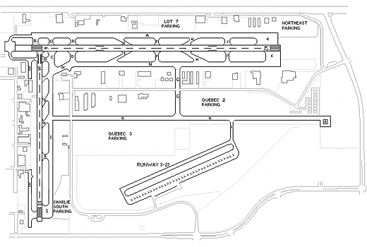 |
Airport Layout
(Click on the photo to enlarge)
|
Location
& QuickFacts
|
FAA
Information Effective: |
2006-02-16 |
|
Airport
Identifier: |
MRI |
|
Longitude/Latitude: |
149-50-40.0070W/61-12-48.7620N
-149.844446/61.213545 (Estimated) |
|
Elevation: |
137 ft / 41.76 m (Surveyed) |
|
Land: |
436 acres |
|
From
nearest city: |
0 nautical miles E of Anchorage, AK |
|
Location: |
Anchorage County, AK |
|
Magnetic Variation: |
25E (1985) |
Owner
& Manager
|
Ownership: |
Publicly owned |
|
Owner: |
Munci Of Anchorage |
|
Address: |
800 Merril Field Dr.
Anchorage, AK 99501-4129 |
|
Phone
number: |
907-343-6303 |
|
Manager: |
David Lundeby |
|
Address: |
800 Merril Field Dr.
Anchorage, AK 99501-4129 |
|
Phone number: |
907-343-6303 |
Airport
Operations and Facilities
|
Airport
Use: |
Open to public |
|
Wind
indicator: |
Yes |
|
Segmented
Circle: |
No |
|
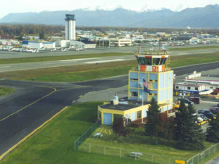
Control
Tower: |
Yes |
|
Attendance
Schedule: |
ALL/MON-FRI/0730-1700 |
|
Lighting
Schedule: |
DUSK-DAWN
ACTVT MIRL RYS 07/25 & 16/34; REIL RYS 07; 25; 16
& 34 - CTAF. |
|
Beacon
Color: |
Clear-Green (lighted land airport) |
|
Landing
fee charge: |
No |
|
Sectional
chart: |
Anchorage |
|
Region: |
AAL - Alaska |
|
Boundary
ARTCC: |
ZAN - Anchorage |
|
Tie-in
FSS: |
ENA - Kenai |
|
FSS
on Airport: |
No |
|
FSS
Phone: |
800-478-3576 |
|
FSS
Toll Free: |
1-800-WX-BRIEF |
|
NOTAMs
Facility: |
MRI (NOTAM-d service avaliable) |
|
Federal Agreements: |
NGSY |
Airport
Communications
|
CTAF: |
126.000 |
|
Unicom: |
122.950 |
Airport
Services
|
Fuel
available: |
100 A |
|
Airframe
Repair: |
MAJOR |
|
Power
Plant Repair: |
MAJOR |
|
Bottled
Oxygen: |
LOW |
|
Bulk
Oxygen: |
LOW |
|
Runway
Information
Runway 04/22
|
Dimension: |
2000 x 60 ft / 609.6 x 18.3 m |
|
Surface: |
GRVL-DIRT, Good Condition |
|
|
Runway 04 |
Runway 22 |
|
Longitude: |
149-50-42.5060W |
149-50-05.1560W |
|
Latitude: |
61-12-34.8190N |
61-12-42.7850N |
|
Elevation: |
130.00 ft |
136.00 ft |
|
Alignment: |
66 |
127 |
|
Traffic
Pattern: |
Left |
Left |
|
Runway 07/25
|
Dimension: |
4000 x 100 ft / 1219.2 x 30.5 m |
|
Surface: |
ASPH, Good Condition |
|
Weight
Limit: |
Single wheel: 50000 lbs.
Dual wheel: 80000 lbs. |
|
Edge
Lights: |
Medium |
|
|
Runway 07 |
Runway 25 |
|
Longitude: |
149-51-11.9000W |
149-49-50.2400W |
|
Latitude: |
61-12-57.2500N |
61-12-57.2400N |
|
Elevation: |
124.00 ft |
137.00 ft |
|
Alignment: |
90 |
127 |
|
Traffic
Pattern: |
Right |
Left |
|
Markings: |
Precision instrument, Good Condition |
Precision instrument, Good Condition |
|
Crossing
Height: |
43.00 ft |
21.00 ft |
|
VASI: |
2-box on left side |
2-box on left side |
|
Visual
Glide Angle: |
3.75� |
3.00� |
|
Runway
End Identifier: |
Yes |
Yes |
|
Centerline
Lights: |
No |
No |
|
Touchdown
Lights: |
No |
No |
|
Obstruction: |
29 ft trees, 760.0 ft from runway, 19:1
slope to clear |
29 ft tree, 864.0 ft from runway, 152 ft
right of centerline, 22:1 slope to clear |
|
Runway 16/34
|
Dimension: |
2640 x 75 ft / 804.7 x 22.9 m |
|
Surface: |
ASPH, Fair Condition |
|
Weight
Limit: |
Single wheel: 20000 lbs. |
|
Edge
Lights: |
Medium |
|
|
Runway 16 |
Runway 34 |
|
Longitude: |
149-51-09.0600W |
149-51-09.0900W |
|
Latitude: |
61-12-56.4500N |
61-12-30.4600N |
|
Elevation: |
124.00 ft |
117.00 ft |
|
Alignment: |
127 |
0 |
|
Traffic
Pattern: |
Right |
Left |
|
Markings: |
Basic, Fair Condition |
Basic, Fair Condition |
|
Crossing
Height: |
22.00 ft |
21.00 ft |
|
VASI: |
2-box on right side |
pulsating/steady burning on left side |
|
Visual
Glide Angle: |
3.00� |
3.00� |
|
Runway
End Identifier: |
Yes |
Yes |
|
Centerline
Lights: |
No |
No |
|
Touchdown
Lights: |
No |
No |
|
Obstruction: |
|
26 ft tree, 321.0 ft from runway, 20 ft
right of centerline, 5:1 slope to clear |
|
Radio
Navigation Aids
|
ID |
Type |
Name |
Ch |
Freq |
Var |
Dist |
|
CMQ |
NDB |
Campbell Lake |
|
338.00 |
21E |
6.4 nm |
|
BOB |
NDB |
Bruck |
|
387.00 |
21E |
10.0 nm |
|
GRP |
NDB |
Granite Point |
|
356.00 |
24E |
45.9 nm |
|
EDF |
TACAN |
Elmendorf |
081X |
|
21E |
3.3 nm |
|
ANC |
VOR/DME |
Anchorage |
090X |
114.30 |
25E |
11.1 nm |
|
BGQ |
VORTAC |
Big Lake |
072X |
112.50 |
25E |
21.7 nm |
|
ANC |
VOT |
Anchorage |
|
108.40 |
|
4.6 nm |
Remarks
-
AREAS
OF TWYS 'G' & 'Q' NOT VSB FM ATCT AND ARE UNCONTROLLED.
-
MERRILL
ARPT WX INFO AVBL ON CTAF (CALL SIGN MERRILL WEATHER) DURG HRS ATCT
CLSD OR PHONE 271-4355 DURING HRS WHEN ATCT CLSD.
-
USE
FREQ 122.55 (RCO) FOR FILING , ACTIVATING & CANCELING FLIGHT
PLANS IN THE ANCHORAGE BOWL AREA.
-
BE
ALERT: RY 04/22 SFC COMPOSITION IS GRVL.
-
HELICOPTERS
BE ALERT: TWY 'G' & TWY 'Q' BARRIER GATES RAISE AUTOMATICALLY
40 FT AGL.
-
PORTIONS
OF TWY 'C' BTN TWY 'S' & 'P' NOT VSBL FM ATCT.
-
ALL
ACFT IN NON-MOVEMENT AREAS MUST CTC GND CTL PRIOR TO TAXI.
-
ANCHORAGE
WX CAMERA AVBL ON INTERNET AT HTTP://AKWEATHERCAMS.FAA.GOV
-
TWY 'Q' UNCONTROLLED.
-
FLOCKS
OF SEAGULLS & RAVENS ON AIRPORT.
-
PPR
FOR ACFT OVR 12500 LBS.
-
ALL
RWY & TWY LGTS NON-STD HEIGHT.
-
1 FT
TO 8 FT SNOW BERMS & PILES ADJACENT TO RYS & TAXIWAYS DURING
WINTER MONTHS.
-
MIGRATORY
WATERFOWL ON ARPT SPRING & FALL.
-
SEE
SEPERATE LISTING FOR HOSP HELI.
Based
Aircraft
|
Aircraft
based on field: |
966 |
|
Single
Engine Airplanes: |
904 |
|
Multi
Engine Airplanes: |
45 |
|
Helicopters: |
16 |
|
Gliders: |
1 |
Operational
Statistics
|
Aircraft
Operations: |
525/Day |
|
General
Aviation Local: |
51.6% |
|
General
Aviation Itinerant: |
48.4% |
Merrill Field Airport
Merrill Field
800 Merrill Field Drive
Anchorage, Alaska 99501
Telephone: (907) 343-6303
Fax: (907) 276-8421
E-mail: merrillinfo@muni.org
URL: http://www.muni.org/merrill1/merrill1.cfm
Images
and information placed above are from
http://www.airport-data.com/airport/MRI/
http://www.muni.org/merrill1/merrill1.cfm
We
thank them for the data!
| General
Info |
| Country |
United
States |
| State |
ALASKA
|
| FAA
ID |
MRI
|
| Latitude |
61-12-51.763N
|
| Longitude |
149-50-46.181W
|
| Elevation |
137
feet |
| Near
City |
ANCHORAGE
|
We don't guarantee the information is fresh and accurate. The data may
be wrong or outdated.
For more up-to-date information please refer to other sources.
|
|