|
|
| McGrath Airport |
 |
| IATA: MCG – ICAO: PAMC – FAA LID: MCG |
| Summary |
| Airport type |
Public |
| Owner |
State of Alaska DOT&PF - Central Region |
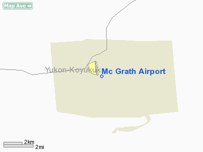
| Serves |
McGrath, Alaska |
| Elevation AMSL |
343 ft / 105 m |
| Coordinates |
62°57′10″N 155°36′20″W / 62.95278°N 155.60556°W / 62.95278; -155.60556 |
| Runways |
| Direction |
Length |
Surface |
| ft |
m |
| 16/34 |
5,936 |
1,809 |
Asphalt |
| 7/25 |
1,720 |
524 |
Asphalt |
| Statistics (2005) |
| Aircraft operations |
11,000 |
| Based aircraft |
44 |
| Source: Federal Aviation Administration |
McGrath Airport (IATA: MCG, ICAO: PAMC, FAA LID: MCG) is a state-owned public-use airport located in the McGrath, a city in the Yukon-Koyukuk Census Area of the U.S. state of Alaska. Facilities and aircraft
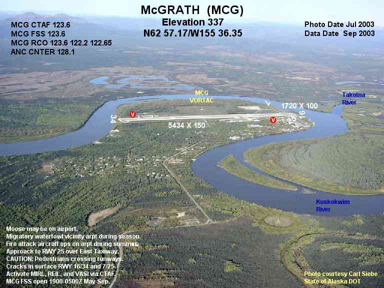
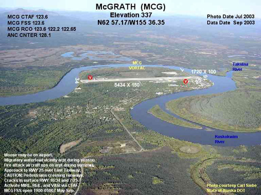
McGrath Airport covers an area of 641 acres (259 ha) at an elevation of 343 feet (105 m) above mean sea level. It has two asphalt paved runways: 16/34 measuring 5,936 x 100 ft (1,809 x 30 m) and 7/25 measuring 1,720 x 60 ft (524 x 18 m).
For the 12-month period ending September 1, 2005, the airport had 11,000 aircraft operations, an average of 30 per day: 82% air taxi and 18% general aviation. At that time there were 44 aircraft based at this airport: 91% single-engine and 9% multi-engine.
Airlines and non-stop destinations
- PenAir (Anchorage)
- Tanana Air Service (Nikolai, Takotna)
The above content comes from Wikipedia and is published under free licenses – click here to read more.
Location
& QuickFacts
|
FAA
Information Effective: |
2006-02-16 |
|
Airport
Identifier: |
MCG |
|
Longitude/Latitude: |
155-36-20.7450W/62-57-10.3450N
-155.605762/62.952874 (Estimated) |
|
Elevation: |
338 ft / 103.02 m (Surveyed) |
|
Land: |
600 acres |
|
From
nearest city: |
0 nautical miles W of Mcgrath, AK |
|
Location: |
Kuskokwim County, AK |
|
Magnetic Variation: |
23E (1985) |
Owner
& Manager
|
Ownership: |
Publicly owned |
|
Owner: |
State Of Ak Dotpf-central Rgn |
|
Address: |
Pouch 196900
Anchorage, AK 99519-6900 |
|
Phone number: |
907-269-0782 |
|
Manager: |
Douglas Lyman |
|
Address: |
Box 21
Mcgrath, AK 99627 |
|
Phone number: |
907-524-3241 |
Airport
Operations and Facilities
|
Airport
Use: |
Open to public |
|
Wind
indicator: |
Yes |
|
Segmented
Circle: |
Yes |
|
Control
Tower: |
No |
|
Attendance
Schedule: |
MAY-SEPT/MON-WED/0700-1730,OCT-APR/MON-FRI/0800
- 1630,MAY-SEPT/THURS/0700-1500 |
|
Lighting
Schedule: |
DUSK-DAWN
ACTVT MIRL RY 16/34; REIL & VASI RYS 16 & 34 - CTAF. |
|
Beacon
Color: |
Clear-Green (lighted land airport) |
|
Landing
fee charge: |
No |
|
Sectional
chart: |
Mc Grath |
|
Region: |
AAL - Alaska |
|
Boundary
ARTCC: |
ZAN - Anchorage |
|
Tie-in
FSS: |
MCG - Mcgrath |
|
FSS
on Airport: |
Yes |
|
FSS
Phone: |
907-524-3611 |
|
FSS
Toll Free: |
LD524-3611 |
|
Alternate
FSS: |
ENA - Kenai |
|
Alt.
FSS Toll Free: |
1-800-WX-BRIEF |
|
NOTAMs
Facility: |
MCG (NOTAM-d service avaliable) |
|
Federal Agreements: |
NGY |
Airport
Communications
Airport
Services
|
Fuel
available: |
100LLA1+
SVC CHRG FOR FUEL SUNDAYS & AFTER 1800 DAILY. |
|
Airframe
Repair: |
MINOR |
|
Power
Plant Repair: |
MINOR |
|
Bottled
Oxygen: |
NONE |
|
Bulk
Oxygen: |
NONE |
|
Runway Information
Runway 07/25
|
Dimension: |
1720 x 60 ft / 524.3 x 18.3 m |
|
Surface: |
ASPH, Poor Condition
RY 07/25 ROUGH WITH MANY CRACKS IN RY SFC. |
|
Edge
Lights: |
Non-standard lighting system
RED RWY EDGE REFLECTORS ON RWY 7-25. GREEN
THR REFLECTORS ON THR RWY 7. |
|
|
Runway 07 |
Runway 25 |
|
Longitude: |
155-36-48.0800W |
155-36-10.9800W |
|
Latitude: |
62-57-31.1800N |
62-57-30.0000N |
|
Elevation: |
335.00 ft |
337.00 ft |
|
Alignment: |
94 |
127 |
|
Traffic
Pattern: |
Left |
Left |
|
Markings: |
Basic, Fair Condition |
Basic, Fair Condition |
|
Runway 16/34
|
Dimension: |
5935 x 100 ft / 1809.0 x 30.5 m |
|
Surface: |
ASPH, Good Condition
RY 07/25 ROUGH WITH MANY CRACKS IN RY SFC. |
|
Surface
Treatment: |
Saw-cut or plastic Grooved |
|
Weight
Limit: |
Single wheel: 32000 lbs.
Dual wheel: 80000 lbs.
Dual
tandem wheel: 120000 lbs. |
|
Edge
Lights: |
Medium
RED RWY EDGE REFLECTORS ON RWY 7-25. GREEN THR REFLECTORS ON THR
RWY 7. |
|
|
Runway 16 |
Runway 34 |
|
Longitude: |
155-36-19.0100W |
155-36-16.5800W |
|
Latitude: |
62-57-33.1200N |
62-56-34.7000N |
|
Elevation: |
338.00 ft |
0.00 ft |
|
Alignment: |
127 |
127 |
|
ILS
Type: |
LOC/DME |
|
|
Traffic
Pattern: |
Left |
Left |
|
Markings: |
Precision instrument, Good Condition |
Precision instrument, Good Condition |
|
Crossing
Height: |
32.00 ft |
41.00 ft |
|
Displaced
threshold: |
556.00 ft |
547.00 ft |
|
VASI: |
4-box on left side |
4-box on left side |
|
Visual
Glide Angle: |
3.00� |
3.00� |
|
Runway
End Identifier: |
Yes |
Yes |
|
Obstruction: |
, 50:1 slope to clear |
15 ft road, 300.0 ft from runway, 6:1 slope
to clear |
|
Decleard
distances: |
Take off run available 5936.00 ft
Take off distance available 5936.00 ft
Actual stop distance available 5390.00 ft
Landing distance available 4833.00 ft |
Take off run available 5936.00 ft
Take off distance available 5936.00 ft
Actual stop distance available 5380.00 ft
Landing distance available 4833.00 ft |
|
Radio Navigation
Aids
|
ID |
Type |
Name |
Ch |
Freq |
Var |
Dist |
|
VTR |
NDB |
Takotna River |
|
350.00 |
23E |
1.4 nm |
|
MCG |
VORTAC |
Mc Grath |
102X |
115.50 |
23E |
0.2 nm |
Remarks
- APCH
TO RWY 25 OVER E APRON CTN: PEDESTRATANS ON RWYS.
- PILOTS
ARE REQUESTED TO SELF-ANNOUNCE ON CTAF PRIOR TO TAXIING ON RWY FOR DEPARTURE;
LEAVING THE RWY AND WITHIN 10 NM OF THE ARPT WHEN APPROACHING TO LAND.
- AIRPORT
HAS DESIGNATED TRANSIENT AIRCRAFT PARKING AVAILABLE. TRANSIENT AIRCRAFT
PARKING IS DESIGNATED BY GREEN CONES.
- RY
16/34 HAS DIPS IN THE SOUTH 1500 FT OF THE RY.
- MOOSE
ON ARPT.
- FIRE
ATTACK ACFT & HELS WORKING OUT OF ARPT DURING SUMMER.
- MIGRATORY
WATER FOWL ON & INVOF ARPT SPRING THRU FALL.
- RY
CONDITION NOT MONITORED; RECOMMEND PILOT ARRANGE FOR VISUAL INSPECTION
AND REPORT BEFORE OPERATING.
- ARPT
CLOSED TO PSGR ACFT CERTIFICATED FOR MORE THAN 30 PSGR SEATS.
- PERSONNEL
AND EQUIPMENT MAY BE WORKING ON THE RY AT ANY TIME.
Based Aircraft
|
Aircraft
based on field: |
44 |
|
Single
Engine Airplanes: |
40 |
|
Multi
Engine Airplanes: |
4 |
Mc Grath Airport
Address:
Kuskokwim County, AK
Tel:
907-269-0782, 907-524-3241
Images
and information placed above are from
http://www.airport-data.com/airport/MCG/
We
thank them for the data!
| General
Info |
| Country |
United
States |
| State |
ALASKA
|
| FAA ID |
MCG
|
| Latitude |
62.952875
62� 57' 10.35" N |
| Longitude |
-155.605764
155� 36' 20.75" W |
| Elevation |
338 feet
103 meters |
| Type |
Civil
|
| Magnetic
Variation |
018� E
(01/06) |
| Operating
Agency |
U.S.CIVIL
AIRPORT WHEREIN PERMIT COVERS USE BY TRANSIT MILITARY AIRCRAFT
|
| Daylight
Savings Time |
First
Sunday in April at 0200 to last Sunday in October at 0200 local time
(Exception Arizona and that portion of Indiana in the Eastern Time
Zone) |
We don't guarantee the information is fresh and accurate. The data may
be wrong or outdated.
For more up-to-date information please refer to other sources.
|
|