 |
|
| Manokotak Airport |
 |
| IATA: KMO – ICAO: PAMB – FAA LID: MBA |
| Summary |
| Airport type |
Public |
| Owner |
State of Alaska DOT&PF - Central Region |
| Serves |
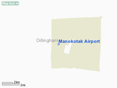
Manokotak, Alaska |
| Elevation AMSL |
51 ft / 16 m |
| Coordinates |
58°59′25″N 159°3′0″W / 58.99028°N 159.05°W / 58.99028; -159.05 |
| Runways |
| Direction |
Length |
Surface |
| ft |
m |
| 1/19 |
2,720 |
829 |
Gravel |
| Statistics (2001) |
| Aircraft operations |
1,200 |
| Source: Federal Aviation Administration |
Manokotak Airport (IATA: KMO, ICAO: PAMB, FAA LID: MBA, formerly 17Z) is a state-owned public-use airport located one mile (2 km) north of the central business district of Manokotak, a city in the Dillingham Census Area of the U.S. state of Alaska.
Although most U.S. airports use the same three-letter location identifier for the FAA and IATA, Manokotak Airport is assigned MBA by the FAA and KMO by the IATA (which assigned MBA to Moi International Airport in Mombasa, Kenya). Facilities and aircraft
Manokotak Airport has one runway designated 1/19 with a 2,720 x 60 ft (829 x 18 m) gravel surface. For the 12-month period ending December 31, 2001, the airport had 1,200 aircraft operations: 83% air taxi and 17% general aviation.
Airlines and non-stop destinations
- PenAir (Dillingham, Twin Hills)
The above content comes from Wikipedia and is published under free licenses – click here to read more.
Location
& QuickFacts
|
FAA
Information Effective: |
2006-02-16 |
|
Airport
Identifier: |
MBA |
|
Longitude/Latitude: |
159-02-59.7260W/58-59-24.7090N
-159.049924/58.990197 (Estimated) |
|
Elevation: |
51 ft / 15.54 m (Surveyed) |
|
Land: |
0 acres |
|
From
nearest city: |
1 nautical miles N of Manokotak, AK |
|
Location: |
Bristol Bay County, AK |
|
Magnetic Variation: |
20E (1985) |
Owner
& Manager
|
Ownership: |
Publicly owned |
|
Owner: |
State Of Ak Dotpf-central Rgn |
|
Address: |
Pouch 196900
Anchorage, AK 99519-6900 |
|
Phone number: |
907-269-0767 |
|
Manager: |
Norman Heyano |
|
Address: |
Box 250
Dillingham, AK 99576 |
|
Phone number: |
907-842-5511 |
Airport
Operations and Facilities
|
Airport
Use: |
Open to public |
|
Wind
indicator: |
Yes |
|
Segmented
Circle: |
Yes |
|
Control
Tower: |
No |
|
Attendance
Schedule: |
UNATNDD |
|
Lighting
Schedule: |
RDO-CTL
ACTVT ROTG BCN & WINDSOCK LGT - CTAF |
|
Beacon
Color: |
Clear-Green (lighted land airport) |
|
Landing
fee charge: |
No |
|
Sectional
chart: |
Kodiak |
|
Region: |
AAL - Alaska |
|
Boundary
ARTCC: |
ZAN - Anchorage |
|
Tie-in
FSS: |
DLG - Dillingham |
|
FSS
on Airport: |
No |
|
FSS
Phone: |
907-842-5275 |
|
FSS
Toll Free: |
LC842-5275 |
|
Alternate
FSS: |
ENA - Kenai |
|
Alt.
FSS Toll Free: |
1-800-WX-BRIEF |
|
NOTAMs
Facility: |
DLG (NOTAM-d service avaliable) |
|
Federal Agreements: |
NGY |
Airport
Communications
Airport
Services
|
Airframe
Repair: |
NONE |
|
Power
Plant Repair: |
NONE |
|
Bottled
Oxygen: |
NONE |
|
Bulk
Oxygen: |
NONE |
|
Runway Information
Runway 01/19
|
Dimension: |
2720 x 60 ft / 829.1 x 18.3 m |
|
Surface: |
GRVL, Good Condition |
|
Edge
Lights: |
Medium |
|
|
Runway 01 |
Runway 19 |
|
Longitude: |
159-03-10.6440W |
159-02-48.8080W |
|
Latitude: |
58-59-12.5540N |
58-59-36.8640N |
|
Elevation: |
26.00 ft |
51.00 ft |
|
Alignment: |
25 |
127 |
|
Traffic
Pattern: |
Left |
Right |
|
Obstruction: |
65 ft ant, 1944.0 ft from runway, 100 ft right
of centerline, 30:1 slope to clear |
, 50:1 slope to clear |
|
Radio Navigation
Aids
|
ID |
Type |
Name |
Ch |
Freq |
Var |
Dist |
|
BTS |
NDB |
Wood River |
|
429.00 |
20E |
15.5 nm |
|
TOG |
NDB/DME |
Togiak |
114X |
393.00 |
19E |
41.2 nm |
|
DLG |
VOR/DME |
Dillingham |
111X |
116.40 |
20E |
15.4 nm |
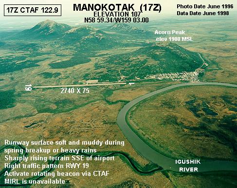
Remarks
- RY
01/19 SAFETY AREA DIMENSIONS 3200' X 120'.
- CAUTION:
RY COND NOT MNTRD; RCMD VISUAL INSPECTION PRIOR TO USE.
- SHARPLY
RISING TERRAIN SSE OF ARPT.
- PILOTS
ARE REQUESTED TO SELF-ANNOUNCE ON CTAF PRIOR TO TAXIING ON RWY FOR DEPARTURE;
LEAVING THE RWY AND WITHIN 10 NM OF THE ARPT WHEN APPROACHING TO LAND.
- WX
CAMERA AVBL ON INTERNET AT HTTP://AKWEATHERCAMS.FAA.GOV
Based Aircraft
|
Aircraft
based on field: |
3 |
|
Single
Engine Airplanes: |
3 |
Operational Statistics
|
Aircraft
Operations: |
24/Week |
|
Air Taxi: |
83.3% |
|
General
Aviation Itinerant: |
16.7% |
Manokotak Airport
Address:
Bristol Bay County, AK
Tel:
907-269-0767, 907-842-5511
Images
and information placed above are from
http://www.airport-data.com/airport/MBA/
We
thank them for the data!
| General
Info |
| Country |
United
States |
| State |
ALASKA
|
| FAA ID |
MBA
|
| Latitude |
58.990197
58� 59' 24.71" N |
| Longitude |
-159.049925
159� 02' 59.73" W |
| Elevation |
51 feet
16 meters |
| Magnetic
Variation |
016� E
(01/06) |
| Operating
Agency |
U.S.CIVIL
AIRPORT WHEREIN PERMIT COVERS USE BY TRANSIT MILITARY AIRCRAFT
|
We don't guarantee the information is fresh and accurate. The data may
be wrong or outdated.
For more up-to-date information please refer to other sources.
|
|


