 |
|
Coordinates: 61°11′13″N 149°57′55″W / 61.18694°N 149.96528°W / 61.18694; -149.96528
| Lake Hood Strip |
 |
| IATA: none – ICAO: none – FAA LID: Z41 |
| Summary |
| Airport type |
Public |
| Owner |
State of Alaska DOT&PF - Central Region |
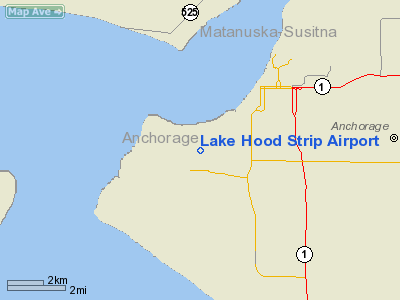
| Location |
Anchorage, Alaska |
| Elevation AMSL |
73 ft / 22 m |
| Runways |
| Direction |
Length |
Surface |
| ft |
m |
| 13/31 |
2,200 |
671 |
Gravel |
| Statistics |
| Based aircraft |
437 |
| Source: Federal Aviation Administration |
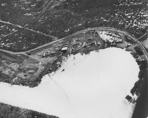
Lake Hood Strip (FAA LID: Z41) is a state-owned public-use general aviation airstrip adjacent to the Lake Hood Seaplane Base (ICAO: PALH, FAA LID: LHD), three miles (5 km) southwest of downtown Anchorage in the U.S. state of Alaska. The airstrip and seaplane base are located at Lake Hood, just east of Ted Stevens Anchorage International Airport.
Facilities and aircraft
Lake Hood Strip has one runway (13/31) with a gravel surface measuring 2,200 x 75 ft. (671 x 23 m). There are 437 aircraft based at this airport: 97% single-engine and 3% multi-engine.
The above content comes from Wikipedia and is published under free licenses – click here to read more.
Location
& QuickFacts
|
FAA
Information Effective: |
2006-02-16 |
|
Airport
Identifier: |
Z41 |
|
Longitude/Latitude: |
149-57-54.9600W/61-11-13.0140N
-149.965267/61.186948 (Estimated) |
|
Elevation: |
73 ft / 22.25 m (Estimated) |
|
Land: |
0 acres |
|
From
nearest city: |
3 nautical miles SW of Anchorage, AK |
|
Location: |
Anchorage County, AK |
|
Magnetic Variation: |
25E (1985) |
Owner
& Manager
|
Ownership: |
Publicly owned |
|
Owner: |
State Of Ak Dot |
|
Address: |
Po Box 196960
Anchorage, AK 99519-6900 |
|
Phone number: |
907-266-1450 |
|
Manager: |
Andy Hutzel |
|
Address: |
Po Box 196960
Anchorage, AK 99519-0204 |
|
Phone number: |
907-266-2741 |
Airport
Operations and Facilities
|
Airport
Use: |
Open to public |
|
Wind
indicator: |
Yes |
|
Segmented
Circle: |
No |
|
Control
Tower: |
No |
|
Attendance
Schedule: |
ALL/ALL/ALL |
|
Lighting
Schedule: |
DUSK-DAWN |
|
Beacon
Color: |
Clear-Green (lighted land airport) |
|
Landing
fee charge: |
No |
|
Sectional
chart: |
Anchorage |
|
Region: |
AAL - Alaska |
|
Boundary
ARTCC: |
ZAN - Anchorage |
|
Tie-in
FSS: |
ENA - Kenai |
|
FSS
on Airport: |
No |
|
FSS
Phone: |
800-478-3576 |
|
FSS
Toll Free: |
1-800-WX-BRIEF |
|
NOTAMs
Facility: |
LHD (NOTAM-d service avaliable) |
Airport
Services
|
Fuel
available: |
100LL |
|
Airframe
Repair: |
MAJOR |
|
Power
Plant Repair: |
MAJOR |
|
Runway Information
Runway 13/31
|
Dimension: |
2200 x 75 ft / 670.6 x 22.9 m |
|
Surface: |
GRAVEL, Good Condition |
|
Edge
Lights: |
Medium |
|
|
Runway 13 |
Runway 31 |
|
Traffic
Pattern: |
Left |
Right |
|
Obstruction: |
40 ft tree, 880.0 ft from runway, 170 ft left
of centerline, 22:1 slope to clear |
27 ft tree, 650.0 ft from runway, 180 ft right
of centerline, 24:1 slope to clear |
|
Radio Navigation
Aids
|
ID |
Type |
Name |
Ch |
Freq |
Var |
Dist |
|
CMQ |
NDB |
Campbell Lake |
|
338.00 |
21E |
2.6 nm |
|
BOB |
NDB |
Bruck |
|
387.00 |
21E |
6.2 nm |
|
GRP |
NDB |
Granite Point |
|
356.00 |
24E |
42.0 nm |
|
EDF |
TACAN |
Elmendorf |
081X |
|
21E |
7.0 nm |
|
ANC |
VOR/DME |
Anchorage |
090X |
114.30 |
25E |
7.3 nm |
|
ENA |
VOR/DME |
Kenai |
123X |
117.60 |
25E |
49.8 nm |
|
BGQ |
VORTAC |
Big Lake |
072X |
112.50 |
25E |
23.0 nm |
|
ANC |
VOT |
Anchorage |
|
108.40 |
|
0.8 nm |
|
MRI |
VOT |
Merrill |
|
111.00 |
|
3.8 nm |
Remarks
- TFC
PATTERNS OVERLAP SEADROME PATTERNS. TRAFFIC
PATTERN ALTITUDE 600'.
- FOR
WSO PHONE 271-3491.
- PPR
FOR NON-RADIO ACFT OPNS DURG DALGT HRS - CALL ANC ATCT 907-271-2700
DURG ADMIN HRS (0730-1600 WKDAYS). DURG NON-ADMIN HRS & HOLIDAYS
CTC FAA AT 907-271-5936. PILOTS MUST PROVIDE AN ETA & REMAIN WITHIN
PLUS OR MINUS 15 MINUTES OF ETA. NO
NIGHTIME NON-RADIO OPNS.
- STRIP
AIR TRAFFIC CTLD BY LAKE HOOD ATCT.
- WATERFOWL
INVOF RY.
- TAXIWAY
AROUND LAKE HOOD IS A JOINT USE TAXIWAY/ROAD & IS USED BY MOTOR
VEHICLES/BICYCLISTS/JOGGERS AND TOUR BUSES. USE
OF LANDING LIGHT WHEN TAXIING RECOMMENDED.
- WX
CAMERA AVBL ON INTERNET AT HTTP://AKWEATHERCAMS.FAA.GOV
Based Aircraft
|
Aircraft
based on field: |
437 |
|
Single
Engine Airplanes: |
425 |
|
Multi
Engine Airplanes: |
12 |
Lake Hood Strip Airport
Address:
Anchorage County, AK
Tel:
907-266-1450, 907-266-2741
Images
and information placed above are from
http://www.airport-data.com/airport/Z41/
We
thank them for the data!
| General
Info |
| Country |
United
States |
| State |
ALASKA
|
| FAA ID |
Z41
|
| Latitude |
61-11-13.014N
|
| Longitude |
149-57-54.960W
|
| Elevation |
73 feet
|
| Near City |
ANCHORAGE
|
We don't guarantee the information is fresh and accurate. The data may
be wrong or outdated.
For more up-to-date information please refer to other sources.
|
|


