|
|
| Kwethluk Airport |
 |
| IATA: KWT – ICAO: PFKW – FAA LID: KWT |
| Summary |
| Airport type |
Public |
| Owner |
State of Alaska DOT&PF - Central Region |
| Serves |
Kwethluk, Alaska |
| Elevation AMSL |
30 ft / 9 m |
| Coordinates |
60°47′25″N 161°26′37″W / 60.79028°N 161.44361°W / 60.79028; -161.44361 |
| Runways |
| Direction |
Length |
Surface |
| ft |
m |
| 18/36 |
3,198 |
975 |
Gravel |
| Statistics |
| Enplanements (2007) |
2,923 |
| Source: Federal Aviation Administration |
Kwethluk Airport (IATA: KWT, ICAO: PFKW, FAA LID: KWT) is a state-owned public-use airport located in Kwethluk, a city in the Bethel Census Area of the U.S. state of Alaska.
As per Federal Aviation Administration records, this airport had 2,923 passenger boardings (enplanements) in calendar year 2007, an increase of 26% from the 2,329 enplanements in 2006. Facilities
Kwethluk Airport has one gravel surfaced runway (18/36) measuring 3,198 by 75 ft. (975 by 23 m).
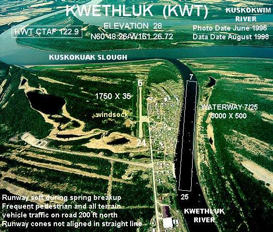
The airport was relocated from its former site at coordinates 60°48.26′N 161°26.72′W / 60.80433°N 161.44533°W / 60.80433; -161.44533 which had a 1,750 by 35 ft runway (6/24) and a 5,000 x 500 ft seaplane landing area.
Airlines
- Hageland Aviation Services
The above content comes from Wikipedia and is published under free licenses – click here to read more.
Location
& QuickFacts
|
FAA
Information Effective: |
2006-02-16 |
|
Airport
Identifier: |
KWT |
|
Longitude/Latitude: |
161-26-37.2800W/60-47-25.2300N
-161.443689/60.790342 (Estimated) |
|
Elevation: |
30 ft / 9.14 m (Estimated) |
|
Land: |
0 acres |
|
From
nearest city: |
0 nautical miles S of Kwethluk, AK |
|
Location: |
Bethel County, AK |
|
Magnetic Variation: |
19E (1985) |
Owner
& Manager
|
Ownership: |
Publicly owned |
|
Owner: |
State Of Ak Dot/pf Cent Reg |
|
Address: |
Po Box 196900
Anchorage, AK 99519-6900 |
|
Phone number: |
907-269-0751 |
|
Manager: |
L.j. Davis |
|
Address: |
Po Box 505
Bethel, AK 99559 |
|
Phone number: |
907-543-2495 |
Airport
Operations and Facilities
|
Airport
Use: |
Open to public |
|
Wind
indicator: |
Yes
WINDSOCK MAY BE UNRELIABLE. |
|
Segmented
Circle: |
Yes |
|
Control
Tower: |
No |
|
Attendance
Schedule: |
UNATNDD |
|
Lighting
Schedule: |
RDO-CTL
ACTVT MIRL RWY 18/36, PAPIS & REILS RYS 18 & 36
& ROTG BCN - CTAF. |
|
Beacon
Color: |
Split-Clear-Green (lighted military airport) |
|
Landing
fee charge: |
No |
|
Sectional
chart: |
Mc Grath |
|
Region: |
AAL - Alaska |
|
Boundary
ARTCC: |
ZAN - Anchorage |
|
Tie-in
FSS: |
ENA - Kenai |
|
FSS
on Airport: |
No |
|
FSS
Phone: |
800-478-3576 |
|
FSS
Toll Free: |
1-800-WX-BRIEF |
|
NOTAMs
Facility: |
BET (NOTAM-d service avaliable) |
|
Federal Agreements: |
N |
Airport
Communications
|
Runway Information
Runway 18/36
|
Dimension: |
3198 x 75 ft / 974.8 x 22.9 m |
|
Surface: |
GRVL, Good Condition |
|
Edge
Lights: |
Medium |
|
|
Runway 18 |
Runway 36 |
|
Longitude: |
161-26-28.4300W |
161-26-46.1300W |
|
Latitude: |
60-47-40.3700N |
60-47-10.0800N |
|
Elevation: |
30.00 ft |
30.00 ft |
|
Traffic
Pattern: |
Left |
Left |
|
Crossing
Height: |
27.00 ft |
28.00 ft |
|
VASI: |
4-light PAPI on left side |
4-light PAPI on left side |
|
Visual
Glide Angle: |
3.00� |
3.20� |
|
Runway
End Identifier: |
Yes |
Yes |
|
Obstruction: |
|
31 ft hill, 1215.0 ft from runway, 100 ft left
of centerline, 39:1 slope to clear |
|
Radio Navigation
Aids
|
ID |
Type |
Name |
Ch |
Freq |
Var |
Dist |
|
ET |
NDB |
Bethel |
|
344.00 |
19E |
11.1 nm |
|
OSE |
NDB |
Oscarville |
|
251.00 |
19E |
12.6 nm |
|
BET |
VORTAC |
Bethel |
088X |
114.10 |
19E |
11.2 nm |
Remarks
- RY
COND NOT MONITORED; RECOMMEND VISUAL INSPECTION PRIOR TO USING.
- PILOTS
ARE REQUESTED TO SELF-ANNOUNCE ON CTAF BEFORE TAXIING ON THE RW FOR
DEPARTURE, LEAVING THE RW AND WITHIN 10 NM OF THE ARPT WHEN APPROACHING
TO LAND.
Kwethluk Airport
Address:
Bethel County, AK
Tel:
907-269-0751, 907-543-2495
Images
and information placed above are from
http://www.airport-data.com/airport/KWT/
We
thank them for the data!
| General
Info |
| Country |
United
States |
| State |
ALASKA
|
| FAA ID |
KWT
|
| Latitude |
60-48-15.307N
|
| Longitude |
161-26-43.260W
|
| Elevation |
28 feet
|
| Near City |
KWETHLUK
|
We don't guarantee the information is fresh and accurate. The data may
be wrong or outdated.
For more up-to-date information please refer to other sources.
|
|