|
|
| Kulik Lake Airport |
 |
| IATA: LKK – ICAO: PAKL – FAA LID: LKK |
| Summary |
| Airport type |
Public |
| Owner |
Katmai National Park |
| Serves |
Kulik Lake, Alaska |
| Elevation AMSL |
717 ft / 219 m |
| Coordinates |
58°58′55″N 155°07′17″W / 58.98194°N 155.12139°W / 58.98194; -155.12139 |
| Runways |
| Direction |
Length |
Surface |
| ft |
m |
| 6/24 |
4,350 |
1,326 |
Gravel |
| 18W/36W |
5,000 |
1,524 |
Water |
| Statistics |
| Enplanements (2008) |
1,842 |
| Source: Federal Aviation Administration |
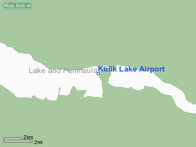
Kulik Lake Airport (IATA: LKK, ICAO: PAKL, FAA LID: LKK) is a public use airport located one nautical mile (1.85 km) south of Kulik Lake, in the Bristol Bay Borough of the U.S. state of Alaska. It is owned by Katmai National Park.
As per Federal Aviation Administration records, Kulik Lake Airport had 1,842 passenger boardings (enplanements) in calendar year 2008, an increase of 21% from the 1,518 enplanements in 2007.
Facilities and aircraft
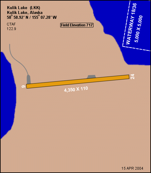
Kulik Lake Airport has one runway designated 6/24 which has a gravel surface measuring 4,350 by 110 feet (1,326 x 34 m). It also has a seaplane landing area designated 18W/36W which measures 5,000 by 5,000 feet (1,524 x 1,524 m). The airport is unattended.
Remarks:
- Runway crowns in center. No line of sight between runway ends.
- East half of runway on national park land & open to the public about 2000 feet; west half of runway on private land & closed to the public about 2000 feet.
- East half runway surface smooth & uniform with compacted gravel. West half runway surface covered with loose 2 inch x 5 inch round stones.
- Ramp on west end of runway privately owned. Yellow barrels mark property line.
- Heavy bear concentration; bears frequently on runway during summer.
- Use extreme caution in high & gusty wind.
- Runway 18W/36W active summer fishing season only - public use.
The above content comes from Wikipedia and is published under free licenses – click here to read more.
Location
& QuickFacts
|
FAA
Information Effective: |
2006-02-16 |
|
Airport
Identifier: |
LKK |
|
Longitude/Latitude: |
155-07-16.5790W/58-58-55.4880N
-155.121272/58.982080 (Estimated) |
|
Elevation: |
717
ft / 218.54 m (Estimated) |
|
Land: |
0
acres |
|
From
nearest city: |
1 nautical miles S of Kulik Lake, AK |
|
Location: |
Bristol Bay County, AK |
|
Magnetic
Variation: |
22E (1985) |
Owner
& Manager
|
Ownership: |
Publicly owned |
|
Owner: |
Katmai Natl Park |
|
Address: |
P.o. Box 7
King Salmon, AK 99613 |
|
Phone
number: |
907-246-3305 |
|
Manager: |
Public Park Supt. |
|
Address: |
P.o. Box 7
King Salmon, AK 99613 |
|
Phone
number: |
907-246-3305 |
Airport
Operations and Facilities
|
Airport
Use: |
Open to public |
|
Wind
indicator: |
No |
|
Segmented
Circle: |
No |
|
Control
Tower: |
No |
|
Attendance
Schedule: |
MAY-SEP/ALL/DALGT |
|
Landing
fee charge: |
Yes |
|
Sectional
chart: |
Kodiak |
|
Region: |
AAL - Alaska |
|
Boundary
ARTCC: |
ZAN - Anchorage |
|
Tie-in
FSS: |
ENA - Kenai |
|
FSS
on Airport: |
No |
|
FSS
Phone: |
800-478-3576 |
|
FSS
Toll Free: |
1-800-WX-BRIEF |
|
NOTAMs
Facility: |
AKN (NOTAM-d service avaliable) |
Airport
Communications
Airport
Services
|
Airframe
Repair: |
NONE |
|
Power
Plant Repair: |
NONE |
|
Bottled
Oxygen: |
NONE |
|
Bulk
Oxygen: |
NONE |
|
Runway Information
Runway 06/24
|
Dimension: |
4350 x 110 ft / 1325.9 x 33.5 m |
|
Surface: |
GRVL, Fair Condition
COVERED WITH LOOSE ROCKS TO 4 INCHES & SEVERAL SOFT SPOTS IN
RY. RY 24 - FIRST 200 FT UNUSBL DUE TO ROCKS. |
|
|
Runway 06 |
Runway 24 |
|
Elevation: |
700.00
ft |
715.00
ft |
|
Traffic
Pattern: |
Left |
Left |
|
Obstruction: |
, 50:1 slope to clear |
60
ft hill, 1200.0 ft from runway, 200 ft left of centerline,
20:1 slope to clear |
|
Runway 18W/36W
|
Dimension: |
5000 x 5000 ft / 1524.0 x 1524.0 m |
|
Surface: |
WATER,
COVERED WITH LOOSE ROCKS TO 4 INCHES & SEVERAL SOFT SPOTS IN
RY. RY 24 - FIRST 200 FT UNUSBL DUE TO ROCKS. |
|
|
Runway 18W |
Runway 36W |
|
Elevation: |
631.00
ft |
631.00
ft |
|
Traffic
Pattern: |
Left |
Left |
|
Radio Navigation
Aids
|
ID |
Type |
Name |
Ch |
Freq |
Var |
Dist |
|
HCP |
NDB |
Kulik Lake |
|
334.00 |
21E |
15.0 nm |
|
ILI |
NDB/DME |
Iliamna |
091X |
411.00 |
20E |
46.5 nm |
Remarks
- RY
18W/36W ACTIVE SUMMER FISHING SEASON ONLY - PUBLIC USE.
- USE
EXTREME CTN IN HIGH & GUSTY WIND.
- RY
06/24 CROWNS IN CENTER. NO LINE OF SIGHT BETWEEN RY ENDS.
- RAMP
ON W END OF RY PRIVATELY OWNED. YELLOW BARRELS MARK PROPERTY LINE.
- EAST
HALF OF RY ON NATL PARK LAND & OPEN TO THE PUBLIC ABOUT 2000'; WEST
HALF OF RY ON PVT LAND & CLSD TO THE PUBLIC ABOUT 2000' - CTC RAYMOND
PETERSON-4700 AIRCRAFT DR; ANCHORAGE AK 99502 OR CALL 907-243-5448.
Based Aircraft
|
Aircraft
based on field: |
1 |
|
Multi
Engine Airplanes: |
1 |
Operational Statistics
|
Aircraft
Operations: |
20/Month |
|
Air Taxi: |
21.7% |
|
General
Aviation Local: |
78.3% |
Kulik Lake Airport
Address: Bristol Bay County, AK
Tel:
907-246-3305
Images
and information placed above are from
http://www.airport-data.com/airport/LKK/
We
thank them for the data!
| General
Info |
| Country |
United
States |
| State |
ALASKA
|
| FAA ID |
LKK
|
| Latitude |
58-58-55.488N
|
| Longitude |
155-07-16.579W
|
| Elevation |
717 feet
|
| Near City |
KULIK
LAKE |
We don't guarantee the information is fresh and accurate. The data may
be wrong or outdated.
For more up-to-date information please refer to other sources.
|
|