|
|
| Koyukuk Airport |
 |
| IATA: KYU – ICAO: PFKU – FAA LID: KYU |
| Summary |
| Airport type |
Public |
| Owner |
State of Alaska DOT&PF - Northern Region |
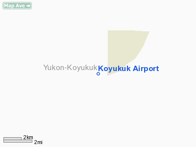
| Serves |
Koyukuk, Alaska |
| Elevation AMSL |
149 ft / 45 m |
| Coordinates |
64°52′33″N 157°43′50″W / 64.87583°N 157.73056°W / 64.87583; -157.73056 |
| Runways |
| Direction |
Length |
Surface |
| ft |
m |
| 6/24 |
4,000 |
1,219 |
Gravel/Dirt |
| Statistics |
| Enplanements (2007) |
1,018 |
| Source: Federal Aviation Administration |
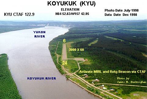
Koyukuk Airport (IATA: KYU, ICAO: PFKU, FAA LID: KYU) is a state-owned public-use airport located in Koyukuk, a city in the Yukon-Koyukuk Census Area of the U.S. state of Alaska.
As per Federal Aviation Administration records, this airport had 1,018 passenger boardings (enplanements) in calendar year 2007, a decrease of 22% from the 1,305 enplanements in 2006. Facilities
Koyukuk Airport covers an area of 287 acres (116 ha) at an elevation of 149 feet (45 m) above mean sea level. It has one runway (6/24) with a gravel and dirt surface measuring 4,000 x 75 ft (1,219 x 23 m). The runway was extended and widened from its former size of 3,000 by 60 feet.
Airlines and non-stop destinations
- Frontier Flying Service (Galena)
- Warbelow's Air Ventures (Galena, Nulato)
- Wright Air Service (Huslia)
The above content comes from Wikipedia and is published under free licenses – click here to read more.
Location
& QuickFacts
|
FAA
Information Effective: |
2006-02-16 |
|
Airport
Identifier: |
KYU |
|
Longitude/Latitude: |
157-43-38.1930W/64-52-33.8920N
-157.727276/64.876081 (Estimated) |
|
Elevation: |
135
ft / 41.15 m (Estimated) |
|
Land: |
0
acres |
|
From
nearest city: |
0 nautical miles W of Koyukuk, AK |
|
Location: |
Yukon-koyukuk County, AK |
|
Magnetic
Variation: |
22E (1985) |
Owner
& Manager
|
Ownership: |
Publicly owned |
|
Owner: |
St Of Ak Dot & Pf/nthn Reg |
|
Address: |
2301 Peger Rd
Fairbanks, AK 99709 |
|
Phone
number: |
907-451-2294 |
|
Manager: |
Bill O'halloran |
|
Address: |
2301 Peger Rd
Fairbanks, AK 99709 |
|
Phone
number: |
907-451-5217 |
Airport
Operations and Facilities
|
Airport
Use: |
Open to public |
|
Wind
indicator: |
Yes |
|
Segmented
Circle: |
No |
|
Control
Tower: |
No |
|
Attendance
Schedule: |
UNATNDD |
|
Lighting
Schedule: |
RDO-CTL
ACTVT ROTG BCN & MIRL RY 06/24 - CTAF. |
|
Beacon
Color: |
Clear-Green (lighted land airport) |
|
Landing
fee charge: |
No |
|
Sectional
chart: |
Fairbanks |
|
Region: |
AAL - Alaska |
|
Boundary
ARTCC: |
ZAN - Anchorage |
|
Tie-in
FSS: |
FAI - Fairbanks |
|
FSS
on Airport: |
No |
|
FSS
Phone: |
907-474-0788 |
|
FSS
Toll Free: |
1-866-248-6516 |
|
NOTAMs
Facility: |
FAI (NOTAM-d service avaliable) |
|
Federal
Agreements: |
N |
Airport
Communications
Airport
Services
|
Airframe
Repair: |
NONE |
|
Power
Plant Repair: |
NONE |
|
Bottled
Oxygen: |
NONE |
|
Bulk
Oxygen: |
NONE |
|
Runway Information
Runway 06/24
|
Dimension: |
2645 x 60 ft / 806.2 x 18.3 m
WEST 355 FT CLOSED INDEFINITELY DUE TO FLOOD DAMAGE. RY 06 USABLE
OVERRUN 232 FT RY 24 USABLE OVERRUN 163 FT. |
|
Surface: |
GRVL-DIRT, Good Condition
SHALLOW RUTS AND GRASS ENCROACHMENT LENGTH OF RY |
|
Edge
Lights: |
Medium |
|
|
Runway 06 |
Runway 24 |
|
Longitude: |
157-44-12.2740W |
157-43-04.1120W |
|
Latitude: |
64-52-31.0460N |
64-52-36.7370N |
|
Elevation: |
127.00
ft |
134.00
ft |
|
Alignment: |
78 |
127 |
|
Traffic
Pattern: |
Left |
Left |
|
Runway
End Identifier: |
No |
No |
|
Centerline
Lights: |
No |
No |
|
Touchdown
Lights: |
No |
No |
|
Obstruction: |
83
ft trees, 1902.0 ft from runway, 66 ft right of centerline,
22:1 slope to clear |
18
ft trees, 714.0 ft from runway, 39:1 slope to clear |
|
Radio Navigation
Aids
|
ID |
Type |
Name |
Ch |
Freq |
Var |
Dist |
|
BZP |
NDB |
Bishop |
|
331.00 |
21E |
25.3 nm |
|
GAL |
VORTAC |
Galena |
095X |
114.80 |
23E |
25.7 nm |
Remarks
- SNOW
REMOVAL OPERATIONS DURING WINTER--MONITOR CTAF.
- RY
CONDITION NOT MONITORED; RECOMMEND VISUAL INSPECTION PRIOR TO LANDING.
- WIND
SOCK NOT RELIABLE DUE TO SURROUNDING TREES.
Koyukuk Airport
Address: Yukon-koyukuk County, AK
Tel:
907-451-2294, 907-451-5217
Images
and information placed above are from
http://www.airport-data.com/airport/KYU/
We
thank them for the data!
| General
Info |
| Country |
United
States |
| State |
ALASKA
|
| FAA ID |
KYU
|
| Latitude |
64-52-33.892N
|
| Longitude |
157-43-38.193W
|
| Elevation |
135 feet
|
| Near City |
KOYUKUK
|
We don't guarantee the information is fresh and accurate. The data may
be wrong or outdated.
For more up-to-date information please refer to other sources.
|
|