|
|
| Kotlik Airport |
 |
| IATA: KOT – ICAO: PFKO – FAA LID: 2A9 |
| Summary |
| Airport type |
Public |
| Owner |
Alaska DOT&PF - Northern Region |
| Serves |
Kotlik, Alaska |
| Elevation AMSL |
15 ft / 5 m |
| Coordinates |
63°01′50″N 163°31′58″W / 63.03056°N 163.53278°W / 63.03056; -163.53278 |
| Runways |
| Direction |
Length |
Surface |
| ft |
m |
| 2/20 |
4,422 |
1,348 |
Gravel |
| Statistics |
| Enplanements (2007) |
4,117 |
| Source: Federal Aviation Administration |
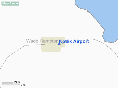
Kotlik Airport (IATA: KOT, ICAO: PFKO, FAA LID: 2A9) is a state-owned public-use airport located one nautical mile (1.85 km) west of the central business district of Kotlik, a city in the Wade Hampton Census Area of the U.S. state of Alaska.
As per Federal Aviation Administration records, this airport had 4,117 passenger boardings (enplanements) in calendar year 2007, an increase of 14% from the 3,654 enplanements in 2006. Facilities
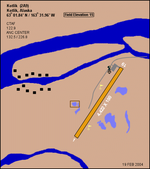
Kotlik Airport covers an area of 185 acres (75 ha) at an elevation of 15 feet (5 m) above mean sea level. It has one runway designated 2/20 with a 4,422 x 100 ft (1,348 x 30 m) gravel surface.
Airlines and non-stop destinations
- Aero Flight (Bethel, Emmonak, Sheldon Point)
- Frontier Flying Service (Unalakleet)
- Hageland Aviation Services
The above content comes from Wikipedia and is published under free licenses – click here to read more.
Location
& QuickFacts
|
FAA
Information Effective: |
2006-02-16 |
|
Airport
Identifier: |
2A9 |
|
Longitude/Latitude: |
163-31-57.5000W/63-01-50.1000N
-163.532639/63.030583 (Estimated) |
|
Elevation: |
15
ft / 4.57 m (Estimated) |
|
Land: |
185
acres |
|
From
nearest city: |
1 nautical miles W of Kotlik, AK |
|
Location: |
Wade Hampton County, AK |
|
Magnetic
Variation: |
15E (1995) |
Owner
& Manager
|
Ownership: |
Publicly owned |
|
Owner: |
State Of Ak/n Reg |
|
Address: |
2301 Peger Rd
Fairbanks, AK 99709 |
|
Phone
number: |
907-624-3261 |
|
Manager: |
Harry Johnson |
|
Address: |
Box 192
Unalakleet, AK 99684 |
|
Phone
number: |
907-443-3444 |
Airport
Operations and Facilities
|
Airport
Use: |
Open to public |
|
Wind
indicator: |
Yes |
|
Segmented
Circle: |
Yes |
|
Control
Tower: |
No |
|
Attendance
Schedule: |
UNATNDD |
|
Lighting
Schedule: |
DUSK-DAWN
ACTVT MIRL RY 02/20 - CTAF |
|
Beacon
Color: |
Clear-Green (lighted land airport) |
|
Sectional
chart: |
Bethel |
|
Region: |
AAL - Alaska |
|
Boundary
ARTCC: |
ZAN - Anchorage |
|
Tie-in
FSS: |
ENA - Kenai |
|
FSS
Phone: |
800-478-3576 |
|
FSS
Toll Free: |
1-800-WX-BRIEF |
|
NOTAMs
Facility: |
ENM (NOTAM-d service avaliable) |
|
Federal
Agreements: |
NGY |
Airport
Communications
|
Runway Information
Runway 02/20
|
Dimension: |
4422 x 100 ft / 1347.8 x 30.5 m |
|
Surface: |
GRVL, |
|
Edge
Lights: |
Medium |
|
|
Runway 02 |
Runway 20 |
|
Longitude: |
163-32-23.1475W |
163-31-31.7635W |
|
Latitude: |
63-01-31.6846N |
63-02-08.4365N |
|
Elevation: |
8.00 ft |
8.00 ft |
|
Alignment: |
32 |
127 |
|
Traffic
Pattern: |
Left |
Left |
|
Radio Navigation
Aids
|
ID |
Type |
Name |
Ch |
Freq |
Var |
Dist |
|
ENM |
VOR/DME |
Emmonak |
125X |
117.80 |
14E |
30.0 nm |
Remarks
- RY
COND NOT MONITORED , RECOMMEND VISUAL INSPECTION PRIOR TO LANDING.
- OLD
RY WEST OF TOWN - CLOSED.
Kotlik Airport
Address: Wade Hampton County, AK
Tel:
907-624-3261, 907-443-3444
Images
and information placed above are from
http://www.airport-data.com/airport/2A9/
We
thank them for the data!
| General
Info |
| Country |
United
States |
| State |
ALASKA
|
| FAA ID |
2A9
|
| Latitude |
63-01-50.100N
|
| Longitude |
163-31-57.500W
|
| Elevation |
15 feet
|
| Near City |
KOTLIK
|
We don't guarantee the information is fresh and accurate. The data may
be wrong or outdated.
For more up-to-date information please refer to other sources.
|
|