| Koliganek Airport |
 |
| IATA: KGK – ICAO: PAJZ – FAA LID: JZZ |
| Summary |
| Airport type |
Public |
| Owner |
State of Alaska DOT&PF |
| Serves |
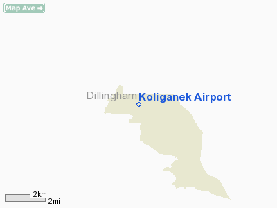
Koliganek, Alaska |
| Elevation AMSL |
269 ft / 82 m |
| Coordinates |
59°43′36″N 157°15′34″W / 59.72667°N 157.25944°W / 59.72667; -157.25944 (Koliganek Airport (new location)) |
| Runways |
| Direction |
Length |
Surface |
| ft |
m |
| 9/27 |
3,000 |
914 |
Gravel |
| Statistics |
| Enplanements (2008) |
481 |
| Source: Federal Aviation Administration |
Koliganek Airport (IATA: KGK, ICAO: PAJZ, FAA LID: JZZ) is a state-owned, public-use airport located one nautical mile (1.85 km) east of the central business district of Koliganek, in the Dillingham Census Area of the U.S. state of Alaska. Scheduled airline service to Dillingham Airport is provided by Peninsula Airways (PenAir).
As per Federal Aviation Administration records, this airport had 481 commercial passenger boardings (enplanements) in calendar year 2008, a decrease of 21% from the 606 enplanements in 2007. Koliganek Airport is included in the FAA's National Plan of Integrated Airport Systems (2009-2013), which categorizes it as a general aviation facility.
Although most U.S. airports use the same three-letter location identifier for the FAA and IATA, this airport is assigned JZZ by the FAA and KGK by the IATA. Airlines and destinations
Facilities and aircraft
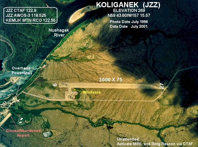
This airport opened in 1997, replacing the former airport located at 59°43′28″N 157°17′09″W / 59.72444°N 157.28583°W / 59.72444; -157.28583 (Koliganek Airport (old location)). The current airport has one runway designated 9/27 with a gravel surface measuring 3,000 by 75 feet (914 × 23 m).
The above content comes from Wikipedia and is published under free licenses – click here to read more.
Location
& QuickFacts
|
FAA
Information Effective: |
2006-02-16 |
|
Airport
Identifier: |
JZZ |
|
Longitude/Latitude: |
157-15-34.1000W/59-43-35.9110N
-157.259472/59.726642 (Estimated) |
|
Elevation: |
269
ft / 81.99 m (Surveyed) |
|
Land: |
0
acres |
|
From
nearest city: |
1 nautical miles E of Koliganek, AK |
|
Location: |
Bristol Bay County, AK |
|
Magnetic
Variation: |
19E (2000) |
Owner
& Manager
|
Ownership: |
Publicly owned |
|
Owner: |
State Of Alaska Dotpf |
|
Address: |
Pouch 196900
Anchorage, AK 99519-6900 |
|
Phone
number: |
907-269-0757 |
|
Manager: |
Norman Heyano |
|
Address: |
Box 250
Dillingham, AK 99576 |
|
Phone
number: |
907-842-5511 |
Airport
Operations and Facilities
|
Airport
Use: |
Open to public |
|
Wind
indicator: |
Yes |
|
Segmented
Circle: |
Yes |
|
Control
Tower: |
No |
|
Attendance
Schedule: |
UNATNDD |
|
Lighting
Schedule: |
RDO-CTL
ACTVT ROTG BCN - CTAF. |
|
Beacon
Color: |
Clear-Green (lighted land airport) |
|
Sectional
chart: |
Kodiak |
|
Region: |
AAL - Alaska |
|
Boundary
ARTCC: |
ZAN - Anchorage |
|
Tie-in
FSS: |
DLG - Dillingham |
|
FSS
on Airport: |
No |
|
FSS
Phone: |
907-842-5275 |
|
FSS
Toll Free: |
LC842-5275 |
|
Alternate
FSS: |
ENA - Kenai |
|
Alt.
FSS Toll Free: |
1-800-WX-BRIEF |
|
NOTAMs
Facility: |
DLG (NOTAM-d service avaliable) |
|
Federal
Agreements: |
NGY |
Airport
Communications
|
Runway Information
Runway 09/27
|
Dimension: |
3000 x 75 ft / 914.4 x 22.9 m |
|
Surface: |
GRVL, |
|
Edge
Lights: |
Medium |
|
|
Runway 09 |
Runway 27 |
|
Longitude: |
157-16-02.2420W |
157-15-05.9570W |
|
Latitude: |
59-43-39.9540N |
59-43-31.8680N |
|
Elevation: |
234.00
ft |
269.00
ft |
|
Alignment: |
106 |
127 |
|
Traffic
Pattern: |
Left |
Left |
|
Radio Navigation
Aids
|
ID |
Type |
Name |
Ch |
Freq |
Var |
Dist |
Remarks
- RY
CONDITIONS NOT MONITORED. RECOMMEND VISUAL INSPECTION PRIOR TO USE.
- PILOTS
ARE REQUESTED TO SELF-ANNOUNCE ON CTAF PRIOR TO TAXIING ON RWY FOR DEPARTURE;
LEAVING THE RWY AND WITHIN 10 NM OF THE ARPT WHEN APPROACHING TO LAND.
- WX
CAMERA AVBL ON INTERNET AT HTTP://AKWEATHERCAMS.FAA.GOV
Koliganek Airport
Address: Bristol Bay County, AK
Tel:
907-269-0757, 907-842-5511
Images
and information placed above are from
http://www.airport-data.com/airport/JZZ/
We
thank them for the data!
| General
Info |
| Country |
United
States |
| State |
ALASKA
|
| FAA ID |
JZZ
|
| Latitude |
59-43-35.911N
|
| Longitude |
157-15-34.100W
|
| Elevation |
269 feet
|
| Near City |
KOLIGANEK
|
We don't guarantee the information is fresh and accurate. The data may
be wrong or outdated.
For more up-to-date information please refer to other sources.
|