|
|
| Kodiak Municipal Airport |
 |
| IATA: KDK – ICAO: PAKD – FAA LID: KDK |
| Summary |
| Airport type |
Public |
| Owner |
City of Kodiak |
| Serves |
Kodiak, Alaska |
| Elevation AMSL |
139 ft / 42 m |
| Coordinates |
57°48′21″N 152°22′26″W / 57.80583°N 152.37389°W / 57.80583; -152.37389 |
| Runways |
| Direction |
Length |
Surface |
| ft |
m |
| 2/20 |
2,475 |
754 |
Asphalt/Gravel |
| Statistics (2006) |
| Aircraft operations |
300 |
| Based aircraft |
12 |
| Source: Federal Aviation Administration |
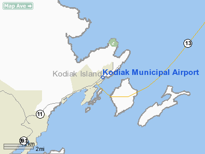
Kodiak Municipal Airport (IATA: KDK, ICAO: PAKD, FAA LID: KDK) is a city-owned public-use airport located two nautical miles (4 km) northeast of the central business district of Kodiak, a city on Kodiak Island in the U.S. state of Alaska.
The FAA's National Plan of Integrated Airport Systems for 2007-2011 categorized this as commercial service airport. However, that classification last applied in calendar year 2004 when the airport had 6,963 passenger boardings (enplanements). That number decreased to 703 in 2005, 6 in 2006, and none in 2007.
Facilities and aircraft
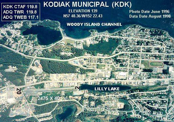
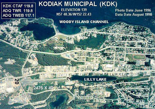
Kodiak Municipal Airport has one runway designated 2/20 with a 2,475 by 40 ft (754 x 12 m) asphalt and gravel surface. For the 12-month period ending December 31, 2006, the airport had 300 aircraft operations, an average of 25 per month, all of which were general aviation.
Four years prior to that the airport had 11,200 aircraft operations in 12 months, 54% general aviation and 46% air taxi.
The above content comes from Wikipedia and is published under free licenses – click here to read more.
Location
& QuickFacts
|
FAA
Information Effective: |
2006-02-16 |
|
Airport
Identifier: |
KDK |
|
Longitude/Latitude: |
152-22-25.8290W/57-48-21.3030N
-152.373841/57.805918 (Estimated) |
|
Elevation: |
139
ft / 42.37 m (Surveyed) |
|
Land: |
0
acres |
|
From
nearest city: |
2 nautical miles NE of Kodiak, AK |
|
Location: |
Kodiak County, AK |
|
Magnetic
Variation: |
22E (1985) |
Owner
& Manager
|
Ownership: |
Publicly owned |
|
Owner: |
City Of Kodiak Pub Works |
|
Address: |
2410 Mill Bay Road
Kodiak, AK 99615 |
|
Phone
number: |
907-486-8060 |
|
Manager: |
Mark Kozak |
|
Address: |
2410 Mill Bay Road
Kodiak, AK 99615 |
|
Phone
number: |
907-486-8060 |
Airport
Operations and Facilities
|
Airport
Use: |
Open to public |
|
Wind
indicator: |
Yes |
|
Segmented
Circle: |
No |
|
Control
Tower: |
No |
|
Attendance
Schedule: |
ALL/ALL/DALGT |
|
Landing
fee charge: |
No |
|
Sectional
chart: |
Kodiak |
|
Region: |
AAL - Alaska |
|
Boundary
ARTCC: |
ZAN - Anchorage |
|
Tie-in
FSS: |
ENA - Kenai |
|
FSS
on Airport: |
No |
|
FSS
Phone: |
800-478-3576 |
|
FSS
Toll Free: |
1-800-WX-BRIEF |
|
NOTAMs
Facility: |
ADQ (NOTAM-d service avaliable) |
|
Federal
Agreements: |
NPY |
Airport
Communications
|
CTAF: |
119.800 |
|
Unicom: |
122.800 |
Airport
Services
|
Airframe
Repair: |
NONE |
|
Power
Plant Repair: |
NONE |
|
Bottled
Oxygen: |
NONE |
|
Bulk
Oxygen: |
NONE |
|
Runway Information
Runway 02/20
|
Dimension: |
2475 x 40 ft / 754.4 x 12.2 m |
|
Surface: |
ASPH, Fair Condition
CENTER OF RY PAVED; PAVEMENT WIDTH VARIES FROM 20 FT WIDE ON RY
20 END TO 40 FT WIDE ON RY 02 END. |
|
|
Runway 02 |
Runway 20 |
|
Traffic
Pattern: |
Right |
Left |
|
Displaced
threshold: |
240.00
ft |
0.00 ft |
|
Obstruction: |
60
ft tree, 840.0 ft from runway, 100 ft right of centerline,
10:1 slope to clear
APCH SLOPE 18:1 TO DSPLCD THR.
+15 FT ROAD 13 FT FM RY END. |
60
ft tree, 720.0 ft from runway, 150 ft left of centerline,
8:1 slope to clear |
|
Radio Navigation
Aids
|
ID |
Type |
Name |
Ch |
Freq |
Var |
Dist |
|
RWO |
NDB |
Woody Island |
|
394.00 |
23E |
2.5 nm |
|
ODK |
VORTAC |
Kodiak |
118X |
117.10 |
23E |
2.2 nm |
Remarks
- CONFLICTING
TFC WITH LAKE BASED ACFT.
- AIRPORT
CLSD EXCEPT DAYLIGHT OPS.
- AIRPORT
CLSD HI/LOW WING ACFT EXCEPT 49 FT OR UNDER.
- RY
20 ROAD CROSSES APCH 15 FT BELOW THR ELEVATION 200 FT FM RY THR.
- RY
02/20 SLOPES UP TO CENTER; NO LINE OF SIGHT BETWEEN RY ENDS. FIRST 350
FT OF RY 02 IS VERY STEEP ABOUT 5%.
- RY
02/20 HAS GRAVEL ON PAVEMENT SFC.
- ARPT
CLSD HI/LOW WING EXCP 49 FT/UNDER.
- NUMEROUS
UNLIT OBSTNS IN VCNTY.
- ARPT
CLSD EXCP DALGT OPN.
- KODIAK
WX CAMERA AVBL ON INTERNET AT HTTP://AKWEATHERCAMS.FAA.GOV
- 1
FT DITCH ADJACENT TO RWY WITHIN 30 FT. OF RWY END.
- NOT
RQRD UNDER FAR 157.
Based Aircraft
|
Aircraft
based on field: |
20 |
|
Single
Engine Airplanes: |
20 |
Operational Statistics
|
Aircraft
Operations: |
216/Week |
|
Air Taxi: |
46.4% |
|
General
Aviation Local: |
44.6% |
|
General
Aviation Itinerant: |
8.9% |
Kodiak Municipal Airport
Address: Kodiak County, AK
Tel:
907-486-8060
Images
and information placed above are from
http://www.airport-data.com/airport/KDK/
We
thank them for the data!
| General
Info |
| Country |
United
States |
| State |
ALASKA
|
| FAA ID |
KDK
|
| Latitude |
57-48-21.303N
|
| Longitude |
152-22-25.829W
|
| Elevation |
139 feet
|
| Near City |
KODIAK
|
We don't guarantee the information is fresh and accurate. The data may
be wrong or outdated.
For more up-to-date information please refer to other sources.
|
|