|
|
| Kodiak Airport |
 |
| IATA: ADQ – ICAO: PADQ – FAA LID: ADQ |
| Summary |
| Airport type |
Public / Military |
| Owner |
State of Alaska DOT&PF - Central Region |
| Location |
Kodiak, Alaska |
| Elevation AMSL |
78 ft / 24 m |
| Coordinates |
57°45′0″N 152°29′38″W / 57.75°N 152.49389°W / 57.75; -152.49389 |
| Runways |
| Direction |
Length |
Surface |
| ft |
m |
| 7/25 |
7,542 |
2,299 |
Asphalt |
| 11/29 |
5,399 |
1,646 |
Asphalt |
| 18/36 |
5,013 |
1,528 |
Asphalt |
| Statistics (2006) |
| Aircraft operations |
41,610 |
| Based aircraft |
55 |
| Source: Federal Aviation Administration |
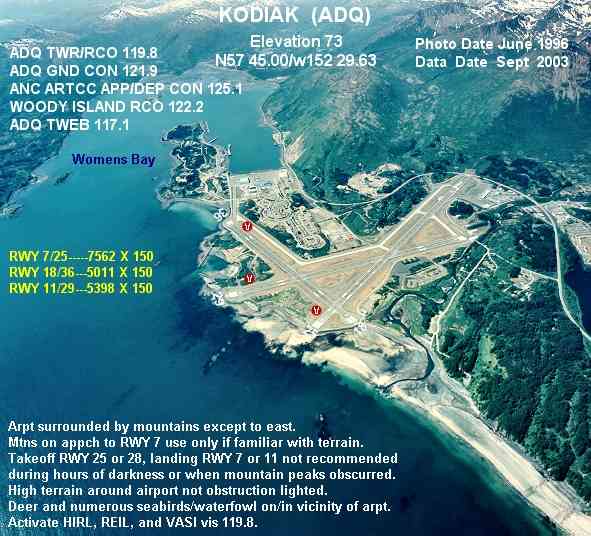
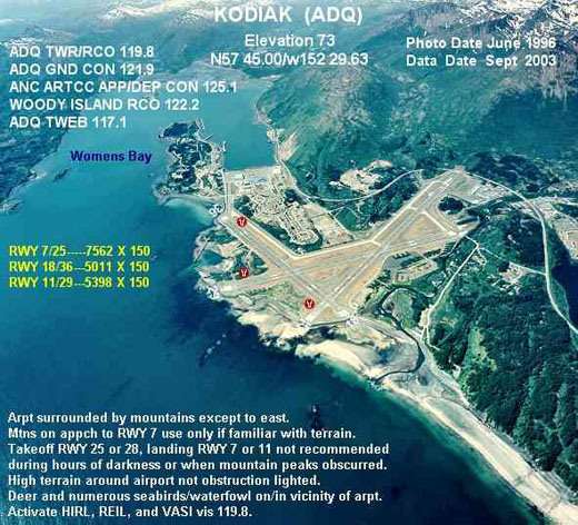
FAA diagram of Kodiak Airport (ADQ) Kodiak Airport (IATA: ADQ, ICAO: PADQ, FAA LID: ADQ) is a joint civil-military public airport located 4 nautical miles (7 km; 5 mi) southwest of the central business district of Kodiak, a city on Kodiak Island in the U.S. state of Alaska. The airport is state-owned and operated by the Alaska Department of Transportation & Public Facilities (DOT&PF) and is home to the colocated Coast Guard Air Station Kodiak. History
The airport is on the site of the former Naval Air Station Kodiak which was commissioned in 1941. NAS Kodiak was closed and placed in caretaker status in 1950, with the exception of runways and other facilities used by or conveyed to the Coast Guard.
In 1947, a U.S. Coast Guard Air Detachment was commissioned at NAS Kodiak, which was formally named Coast Guard Air Station Kodiak in 1964. In 1971, the U.S. Navy turned all airport runways and all remaining areas in caretaker status to the north over to the State of Alaska. CGAS Kodiak remains in operation at this location with four HC-130 Hercules, five HH-60J Jayhawk and five HH-65C Dolphin aircraft.
Facilities and aircraft
 | |
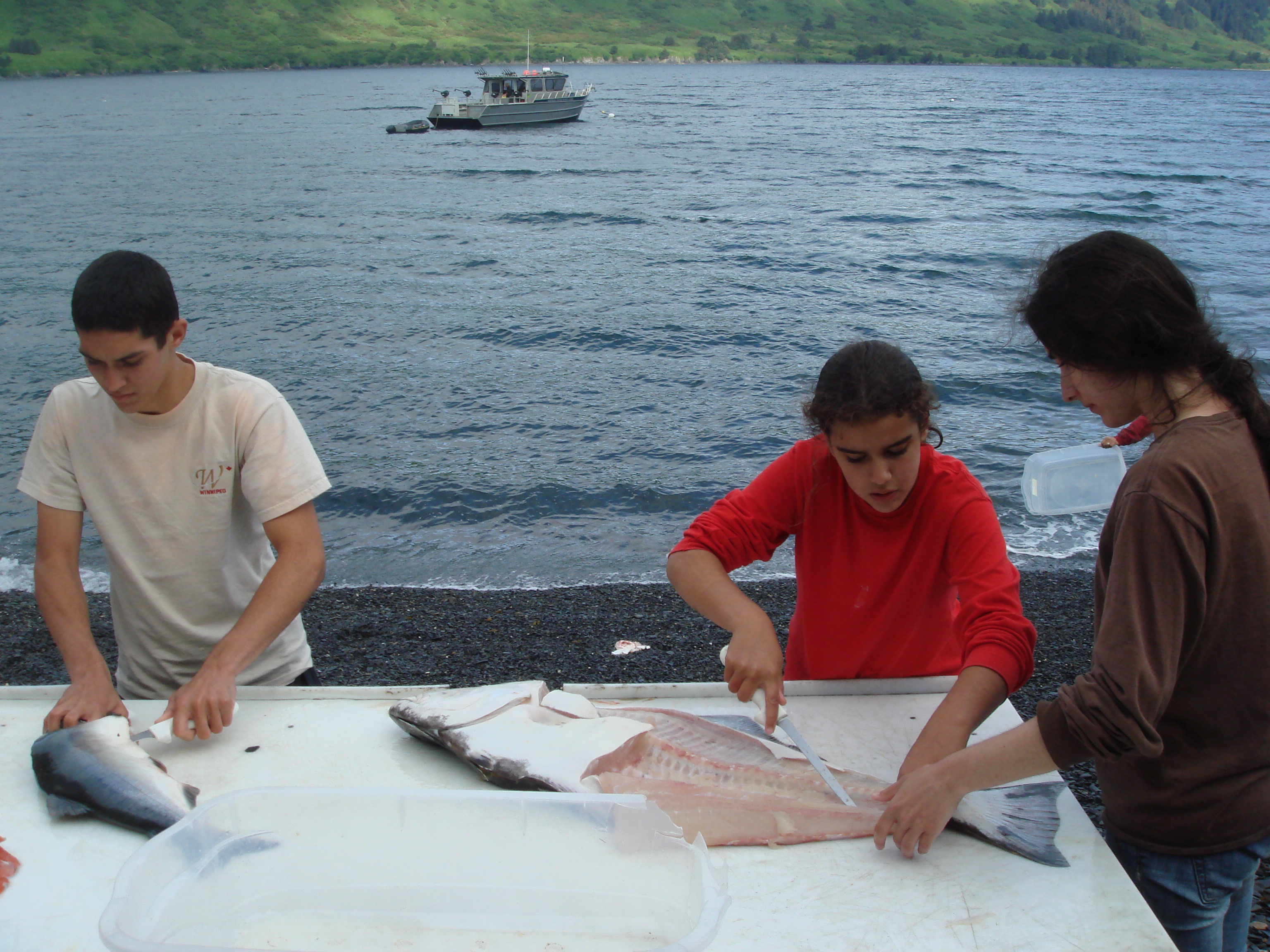
Teenage tourists filleting fish at a lodge on Raspberry Island. The fish is immediately vacuum packed and frozen then put into coolers and checked on as baggage at Kodiak Airport upon departure. Almost all air travellers leaving Kodiak airport have several coolers containing frozen fish they caught themselves and both Kodiak and Anchorage airports have freezers to keep these traveller's fish frozen in case of delay. |
Kodiak Airport has three runways:
- Runway 7/25: 7,542 x 150 ft (2,299 x 46 m), Surface: Asphalt
- Runway 11/29: 5,399 x 150 ft (1,646 x 46 m), Surface: Asphalt
- Runway 18/36: 5,013 x 150 ft (1,528 x 46 m), Surface: Asphalt
For 12-month period ending September 3, 2004, the airport had 28,970 aircraft operations, an average of 79 per day: 52% military, 27% air taxi, 16% general aviation and 5% scheduled commercial. There are 55 aircraft based at this airport: 45% single engine, 15% multi-engine, 15% helicopters and 25% military (14). Airlines and destinations
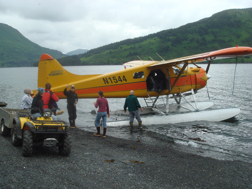 | |
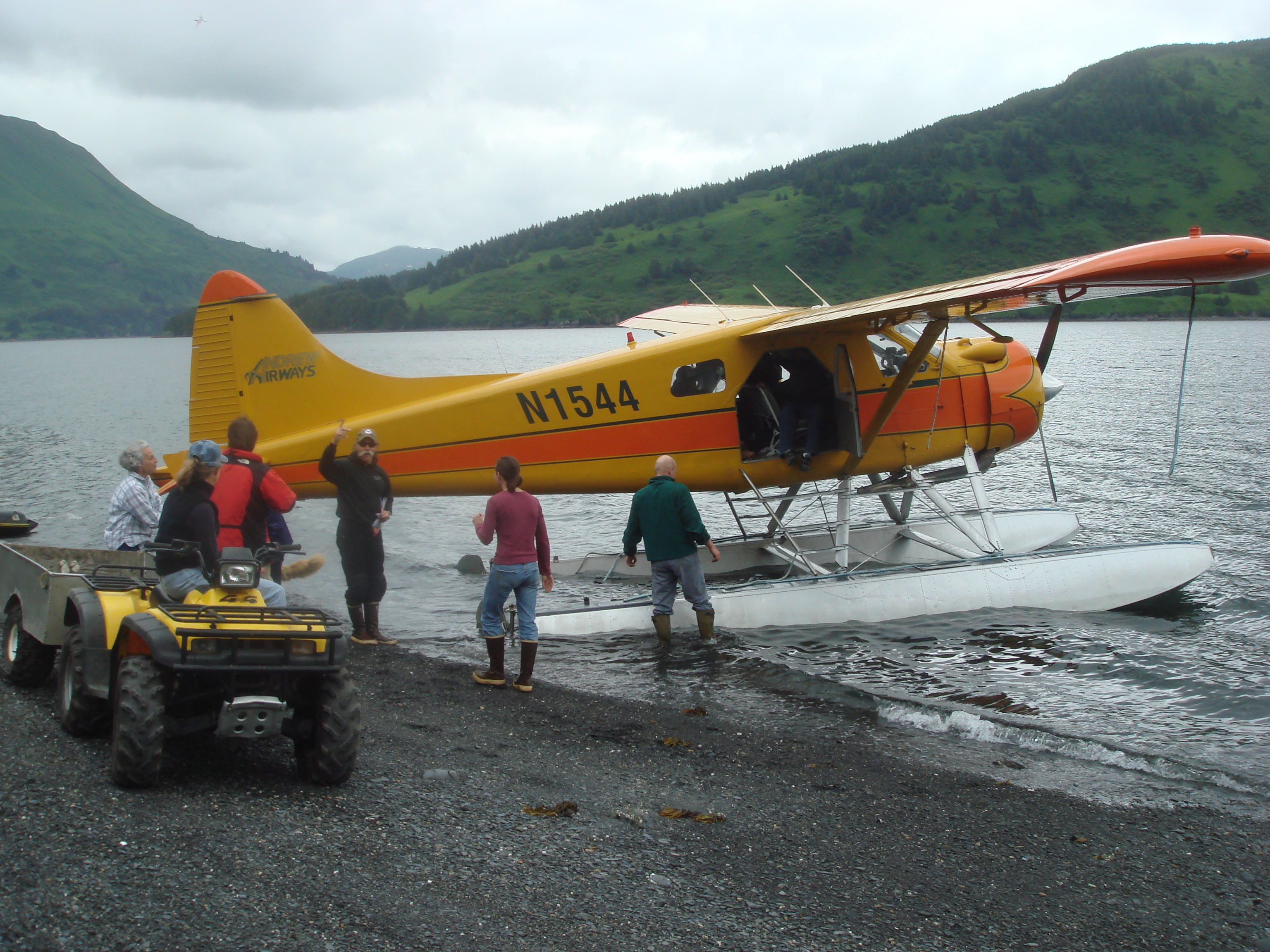
A De Haviland Beaver, part of the Andrew's Airways fleet dropping off tourists at a remote lodge on Raspberry Island (Alaska) |
- Alaska Airlines (Anchorage)
- Era Aviation (Anchorage)
- Island Air Service (Akhiok, Homer [seasonal], Karluk, Larsen Bay, Old Harbor, Ouzinkie, Port Lions)
- Floatplane Service (Alitak, Amook, Kitoi, Moser Bay, Olga Bay, Port Bailey, Port Williams, Seal Bay, Uganik, West Point, Zachar Bay)
- Servant Air (Akhiok, Karluk, Larsen Bay, Old Harbor, Ouzinkie, Port Lions)
Charter/Tours
Charters are generally available to the Kodiak archipelago and Katami coast.
- Andrews Airways
- Island Air Service
- Servant Air
The above content comes from Wikipedia and is published under free licenses – click here to read more.
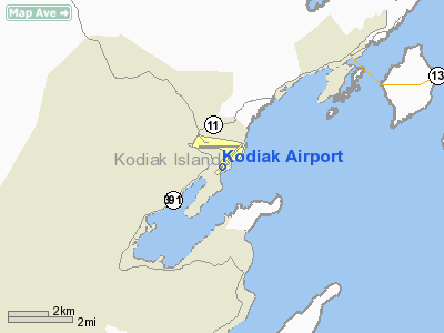
Location
& QuickFacts
|
FAA
Information Effective: |
2006-02-16 |
|
Airport
Identifier: |
ADQ |
|
Longitude/Latitude: |
152-29-37.8790W/57-44-59.8840N
-152.493855/57.749968 (Estimated) |
|
Elevation: |
73
ft / 22.25 m (Surveyed) |
|
Land: |
0
acres |
|
From
nearest city: |
4 nautical miles SW of Kodiak, AK |
|
Location: |
Kodiak County, AK |
|
Magnetic
Variation: |
23E (1980) |
Owner
& Manager
|
Ownership: |
Publicly owned |
|
Owner: |
State Of Ak Dotpf-central Rgn |
|
Address: |
P O Box 196900
Anchorage, AK 99519-6900 |
|
Phone
number: |
907-269-0767 |
|
Manager: |
Bob Greene |
|
Address: |
1500 Anton Larson Rd
Kodiak, AK 99615 |
|
Phone
number: |
907-487-4952 |
Airport
Operations and Facilities
|
Airport
Use: |
Open to public |
|
Wind
indicator: |
Yes |
|
Segmented
Circle: |
Yes |
|
Control
Tower: |
Yes |
|
Attendance
Schedule: |
SAME AS ARPT MAINT HRS
FOR INFORMATION ON ARPT CALL 907-487-4952 MON-FRI 0800-1600. |
|
Lighting
Schedule: |
DUSK-DAWN
ACTVT HIRL RYS 07/25 11/29 & 18/36; REIL RYS 25 36;
VASI RYS 25 29 36 & TWY LGTS - 119.8. |
|
Beacon
Color: |
Clear-Green (lighted land airport) |
|
Landing
fee charge: |
No |
|
Sectional
chart: |
Kodiak |
|
Region: |
AAL - Alaska |
|
Boundary
ARTCC: |
ZAN - Anchorage |
|
Tie-in
FSS: |
ENA - Kenai |
|
FSS
on Airport: |
No |
|
FSS
Phone: |
800-478-3576 |
|
FSS
Toll Free: |
1-800-WX-BRIEF |
|
NOTAMs
Facility: |
ADQ (NOTAM-d service avaliable) |
|
Certification
type/date: |
I AS 5/1973
CLSD TO ACR OPNS WITH MORE THAN 30 PSGR SEATS EXCP PPR IN
WRITING TO AMGR P.O. BOX 1500 ANTON LARSON ROAD KODIAK AK
99615. |
|
Federal
Agreements: |
NGY |
Airport
Communications
|
CTAF: |
119.800 |
|
Unicom: |
122.800 |
Airport
Services
|
Fuel
available: |
100LLA1 |
|
Airframe
Repair: |
MINOR |
|
Power
Plant Repair: |
MINOR |
|
Bottled
Oxygen: |
NONE |
|
Bulk
Oxygen: |
NONE |
|
Runway Information
Runway 07/25
|
Dimension: |
7548 x 150 ft / 2300.6 x 45.7 m |
|
Surface: |
ASPH, Good Condition |
|
Surface Treatment: |
Saw-cut or plastic Grooved |
|
Weight Limit: |
Single wheel: 53000 lbs.
Dual wheel: 110000 lbs.
Dual tandem wheel: 150000 lbs. |
|
Edge Lights: |
High |
|
|
Runway 07 |
Runway 25 |
|
Longitude: |
152-31-08.6800W |
152-28-49.6530W |
|
Latitude: |
57-45-07.9110N |
57-45-05.2960N |
|
Elevation: |
78.00 ft |
15.00 ft |
|
Alignment: |
92 |
127 |
|
ILS Type: |
|
ILS/DME |
|
Traffic Pattern: |
Left |
Right |
|
Markings: |
Precision instrument, Good Condition |
Precision instrument, Good Condition |
|
Crossing Height: |
0.00 ft |
55.00 ft |
|
Displaced threshold: |
1138.00 ft |
0.00 ft |
|
VASI: |
|
4-box on left side
VASI RWY REFERENCE POINT 1420' FROM THR. |
|
Visual Glide Angle: |
0.00� |
2.05� |
|
Runway End Identifier: |
|
Yes |
|
Obstruction: |
2432 ft hill, 5100.0 ft from runway, 2:1 slope to clear
APCH RATIO 2:1 TO DSPLCD THLD.
7' BLAST PROTECTION BARRIER 40' FROM THR; STATE HWY 60' FROM
THR. |
, 50:1 slope to clear |
|
Decleard distances: |
Take off run available 7562.00 ft
Take off distance available 7562.00 ft
Actual stop distance available 7562.00 ft
Landing distance available 6424.00 ft |
Take off run available 6424.00 ft
Take off distance available 6424.00 ft
Actual stop distance available 6424.00 ft
Landing distance available 7562.00 ft |
|
Runway 11/29
|
Dimension: |
5398 x 150 ft / 1645.3 x 45.7 m |
|
Surface: |
ASPH, Good Condition |
|
Surface Treatment: |
Saw-cut or plastic Grooved |
|
Weight Limit: |
Single wheel: 53000 lbs.
Dual wheel: 110000 lbs.
Dual tandem wheel: 150000 lbs. |
|
Edge Lights: |
High |
|
|
Runway 11 |
Runway 29 |
|
Longitude: |
152-30-08.3429W |
152-28-48.9041W |
|
Latitude: |
57-45-17.7196N |
57-44-45.6971N |
|
Elevation: |
32.00 ft |
21.00 ft |
|
Alignment: |
127 |
127 |
|
Traffic Pattern: |
Left |
Right |
|
Markings: |
Basic, Good Condition |
Basic, Good Condition |
|
Crossing Height: |
0.00 ft |
53.00 ft |
|
Displaced threshold: |
441.00 ft |
557.00 ft |
|
VASI: |
|
4-box on left side |
|
Visual Glide Angle: |
0.00� |
3.00� |
|
Obstruction: |
60 ft trees, 560.0 ft from runway, 6:1 slope to clear
APCH SLOPE 16:1 TO DSPLCD THLD. |
, 50:1 slope to clear |
|
Decleard distances: |
Take off run available 4843.00 ft
Take off distance available 4843.00 ft
Actual stop distance available 4843.00 ft
Landing distance available 4402.00 ft |
Take off run available 4959.00 ft
Take off distance available 4959.00 ft
Actual stop distance available 4959.00 ft
Landing distance available 4402.00 ft |
|
Runway 18/36
|
Dimension: |
5011 x 150 ft / 1527.4 x 45.7 m |
|
Surface: |
ASPH, Good Condition |
|
Surface Treatment: |
Saw-cut or plastic Grooved |
|
Weight Limit: |
Single wheel: 53000 lbs.
Dual wheel: 110000 lbs.
Dual tandem wheel: 150000 lbs. |
|
Edge Lights: |
High |
|
|
Runway 18 |
Runway 36 |
|
Longitude: |
152-28-58.3580W |
152-29-33.4600W |
|
Latitude: |
57-45-10.6330N |
57-44-24.9660N |
|
Elevation: |
15.00 ft |
30.00 ft |
|
Alignment: |
127 |
22 |
|
Traffic Pattern: |
Left |
Right |
|
Markings: |
Basic, Good Condition |
Basic, Good Condition |
|
Crossing Height: |
0.00 ft |
43.00 ft |
|
VASI: |
|
4-box on left side |
|
Visual Glide Angle: |
0.00� |
3.75� |
|
Runway End Identifier: |
|
Yes
REIL ARE OMNIDIRECTIONAL TO ACCOMMODATE CIRCLING APPROACHES. |
|
Obstruction: |
, 50:1 slope to clear |
130 ft trees, 3000.0 ft from runway, 21:1 slope to clear |
|
Radio Navigation
Aids
|
ID |
Type |
Name |
Ch |
Freq |
Var |
Dist |
|
RWO |
NDB |
Woody Island |
|
394.00 |
23E |
5.7 nm |
|
ODK |
VORTAC |
Kodiak |
118X |
117.10 |
23E |
5.2 nm |
Remarks
- JASU-5(A/M32A-86);
1(MA-1A).
- ALL
TRANSIENT MILITARY ACFT CONTACT MAINTENANCE ON 164.550 OR KODIAK AIR
ON 345.0 FOR MARSHALLER.
- HIGH
TERRAIN AROUND ARPT IS NOT OBSTRUCTION LGTD.
- MOUNTAIN
ON APCH TO RY 07. RECOMMEND USE OF RY 07 ONLY BY PILOTS FAMILIAR WITH
TERRAIN.
- PERSONNEL
AND EQUIPMENT MAY BE WORKING ON THE RY AT ANY TIME.
- 72
HOUR ADVANCE PPR REQUIRED FOR ACCESS TO CG RAMP. TRANSIENT CREW MUST
PROVIDE TECHNICAL/DIREC/ASSISTANCE IN SVC/MAINT. NO SVC/MAINT AVBL MON-FRI
2000-0800 OR SAT, SUN OR HOL 1600-0800. EXPECT DELAYS OTHER TIMES EXCEPT
SAR AND MEDEVAC V487-5889 C907-487-5889.
- ALL
ARR ACFT CTC KODIAK AIR ON 345.0 OR 164.55 FOR CLEARANCE ONTO CG RAMP,
MARSHALLER AND PARKING SVCS. BE ALERT: TAXIWAY TO CG RAMP CROSSES TWO
ROADWAYS, ACTIVATE CROSSING LIGHTS KEY 122.8 5 TIMES-ON 7 TIMES-OFF.BE
ALERT: NON-STANDARD TAXI LINE OBSTRUCTION CLEARANCE ON CG RAMP.
- CG
RAMP UNSUITABLE FOR AIRCRAFT LARGER THEN A C130 WINGSPAN (132.5 FT).
- WX
CAMERA AVBL ON INTERNET AT HTTP://AKWEATHERCAMS.FAA.GOV
- FIRST
3000' RWY 07 AND ASSOCD TWY NOT VISIBLE FROM TWR. CAUTION ADVISED.
- DEER
NUMEROUS SEABIRDS AND MIGRATORY WATERFOWL ON AND INVOF OF ARPT.
- NO
SNOW REMOVAL OR DEICING FOR RY; TAXIWAY & RAMP 2300-0500.
- LIMITED
PARKING AVBL.
- ARPT
SVC ROAD WITHIN 50' OF THR ON ALL RWYS.
- TAKE
OFF RWY 25 OR RWY 29 OR LNDG RWY 7 OR RWY 11 NOT RECOMMENDED DRG HRS
OF DARKNESS OR WHEN MTN PEAKS ARE OBSCD.
- PORTIONS
OF ALL TAXIWAYS NOT VISIBLE FROM TOWER DUE TO VEGETATION GROWTH.
Based Aircraft
|
Aircraft
based on field: |
55 |
|
Single
Engine Airplanes: |
25 |
|
Multi
Engine Airplanes: |
8 |
|
Helicopters: |
8 |
|
Military: |
14 |
Major Carriers
Serving This Airport
Most Popular Destinations
| Ted Stevens Anchorage Intl (ANC) |
100.0% |
Most Popular Aircraft
|
N745AS |
19.0% |
| N747AS |
18.5% |
|
N741AS |
15.2% |
| N742AS |
11.4% |
|
N746AS |
11.4% |
| 000000 |
10.9% |
|
N740AS |
7.1% |
| N730AS |
6.0% |
|
N783AS |
0.5% |
Operational Statistics
|
Aircraft
Operations: |
84/Day |
|
Air Carrier: |
5.2% |
|
Air Taxi: |
25.6% |
|
General
Aviation Local: |
5.9% |
|
General
Aviation Itinerant: |
9.2% |
|
Military: |
49.0% |
Kodiak Airport
Address: Kodiak County, AK
Tel:
907-269-0767, 907-487-4952
Images
and information placed above are from
http://www.airport-data.com/airport/ADQ/
We
thank them for the data!
| General
Info |
| Country |
United
States |
| State |
ALASKA
|
| FAA ID |
ADQ |
| Latitude |
57-44-59.884N
|
| Longitude |
152-29-37.879W
|
| Elevation |
73 feet
|
| Near City |
KODIAK
|
We don't guarantee the information is fresh and accurate. The data may
be wrong or outdated.
For more up-to-date information please refer to other sources.
|
|