 |
|
| King Salmon Airport |
 |
| IATA: AKN – ICAO: PAKN – FAA LID: AKN |
| Summary |
| Airport type |
Public |
| Owner |
State of Alaska DOT&PF - Central Region |
| Serves |
King Salmon, Alaska |
| Hub for |
PenAir |
| Elevation AMSL |
73 ft / 22 m |
| Coordinates |
58°40′36″N 156°38′57″W / 58.67667°N 156.64917°W / 58.67667; -156.64917 |
| Runways |
| Direction |
Length |
Surface |
| ft |
m |
| 11/29 |
8,501 |
2,591 |
Asphalt |
| 18/36 |
4,018 |
1,225 |
Asphalt |
| NW/SE |
4,000 |
1,219 |
Water |
| Statistics (2007) |
| Aircraft operations |
51,300 |
| Based aircraft |
42 |
| Source: Federal Aviation Administration |
King Salmon Airport (IATA: AKN, ICAO: PAKN, FAA LID: AKN) is a state-owned public-use airport located just southeast of King Salmon, in Bristol Bay Borough, Alaska, United States. It was formerly the Naknek Air Force Base, named for its location near the Naknek River. Facilities and aircraft
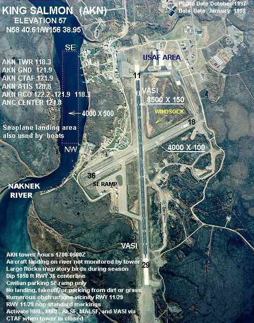
King Salmon Airport covers an area of 5,277 acres (2,136 ha) at an elevation of 73 feet (22 m) above mean sea level. It has two asphalt paved runways: 11/29 measuring 8,501 x 150 ft (2,591 x 46 m) and 18/36 measuring 4,018 x 100 ft (1,225 x 30 m). It is bordered by the Naknek River which has a seaplane landing area designated NW/SE and measuring 4,000 x 500 ft. (1,219 x 152 m).
For the 12-month period ending January 1, 2007, the airport had 51,300 aircraft operations, an average of 140 per day: 66% general aviation, 32% air taxi, 1% scheduled commercial and 1% military. At that time there were 42 aircraft based at this airport: 79% single-engine, 14% multi-engine and 7% helicopter.
Airlines and destinations
- Alaska Airlines (Anchorage)
- Katmai Air (Brooks Camp)
- PenAir (Anchorage, Chignik Bay, Chignik Lagoon, Chignik Lake, Dillingham, Egegik, Igiugig, Levelock, Perryville, Pilot Point, Port Heiden, South Naknek, Wildman Lake)
Accidents and incidents
On 30 June 1985, Douglas C-47B N168Z of Northern Peninsula Fisheries was substantially damaged at King Salmon when both engines failed on approach whilst the aircraft was on an executive flight from Homer Airport, Alaska. The cause of the accident was fuel exhaustion. A fuel filler cap was discovered to be missing after the accident.
The above content comes from Wikipedia and is published under free licenses – click here to read more.
King Salmon Airport (AKN)
King Salmon airport is the
summer hub for wilderness and fishing adventures in the area. The Air
Force Base has been closed, although it is maintained under contract by
Chugach Development Corp. King Salmon is a transportation hub for Bristol
Bay. Formerly an Air Force Base, the State-owned airport offers an 8,500'
paved, lighted runway, a 4,000' asphalt/gravel crosswind runway, and FAA
air traffic control tower. There are scheduled jet flights and charter
services to and from Anchorage. A 4,000' stretch of the Naknek River is
designated for float planes. A seaplane base is also located at Lake Brooks,
within the Katmai National Park to the east. Four docks are available
on the Naknek River -- owned by the U.S. Park Service, U.S.
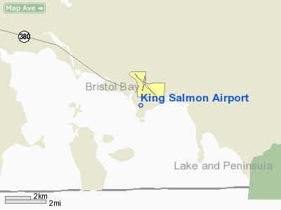
Location and Climate
King Salmon is located on the north bank
of the Naknek River on the Alaska Peninsula, about 15 miles upriver from
Naknek. It is 284 miles southwest of Anchorage. It lies at approximately
58.688330° North Latitude and -156.66139° West Longitude. (Sec.
23, T017S, R045W, Seward Meridian.) King Salmon is located in the Kvichak
Recording District. The area encompasses 169.6 sq. miles of land and 1.4
sq. miles of water. The climate is mainly maritime, characterized by cool,
humid, and windy weather. Average summer temperatures range from 42 to
63; average winter temperatures range from 29 to 44. Extremes from -46
to 88 have been recorded. Total precipitation is 20 inches annually, including
45 inches of snowfall. Fog is common during summer months.
Location
& QuickFacts
|
FAA
Information Effective: |
2006-02-16 |
|
Airport
Identifier: |
AKN |
|
Longitude/Latitude: |
156-38-57.1830W/58-40-36.4860N
-156.649217/58.676802 (Estimated) |
|
Elevation: |
57 ft / 17.37 m (Surveyed) |
|
Land: |
5277 acres |
|
From
nearest city: |
0 nautical miles SE of King Salmon, AK |
|
Location: |
Bristol Bay County, AK |
|
Magnetic
Variation: |
21E (1985) |
Owner
& Manager
|
Ownership: |
Publicly owned |
|
Owner: |
State Of Ak Dotpf-central Rgn |
|
Address: |
Pouch 196900
Anchorage, AK 99519-6900 |
|
Phone
number: |
907-269-0751 |
|
Manager: |
Zane Walker |
|
Address: |
Po Box 65
King Salmon, AK 99613 |
|
Phone
number: |
907-246-3325 |
Airport
Operations and Facilities
|
Airport
Use: |
Open to public |
|
Wind
indicator: |
Yes |
|
Segmented
Circle: |
Yes |
|
Control
Tower: |
Yes |
|
Attendance
Schedule: |
ALL/ALL/0800-1600 |
|
Lighting
Schedule: |
DUSK-DAWN
WHEN ATCT CLOSED ACTVT MIRL RY 18/36, HIRL RY 11/29, ALSF2
RY 11, PAPI RYS 11 & 29, & REIL RY 11 - CTAF. |
|
Beacon
Color: |
Clear-Green (lighted land airport) |
|
Sectional
chart: |
Kodiak |
|
Region: |
AAL - Alaska |
|
Boundary
ARTCC: |
ZAN - Anchorage |
|
Tie-in
FSS: |
ENA - Kenai |
|
FSS
on Airport: |
No |
|
FSS
Phone: |
800-478-3576 |
|
FSS
Toll Free: |
1-800-WX-BRIEF |
|
NOTAMs
Facility: |
AKN (NOTAM-d service avaliable) |
|
Certification
type/date: |
I BS 3/1978
CLSD TO ACR OPNS WITH MORE THAN 30 PSGR SEATS EXCP PPR IN
WRITING TO AMGR PO BOX 65 KING SALMON AK, 99613. |
|
Federal
Agreements: |
NGY |
Airport
Communications
Airport
Services
|
Fuel
available: |
100LLA B
100LL & JET A AVBL AT SEAPLANE BASE FROM FUEL TRUCK. |
|
Airframe
Repair: |
MAJOR |
|
Power
Plant Repair: |
MAJOR |
|
Bottled
Oxygen: |
NONE |
|
Bulk
Oxygen: |
NONE |
|
Runway Information
Runway 11/29
|
Dimension: |
8500 x 150 ft / 2590.8 x 45.7 m |
|
Surface: |
ASPH, Fair Condition |
|
Surface
Treatment: |
Saw-cut or plastic Grooved |
|
Weight
Limit: |
Single wheel: 67000 lbs.
Dual wheel: 90000 lbs.
Dual tandem wheel: 175000 lbs. |
|
Edge
Lights: |
High |
|
|
Runway 11 |
Runway 29 |
|
Longitude: |
156-39-52.2430W |
156-37-52.4840W |
|
Latitude: |
58-41-02.0220N |
58-40-06.1610N |
|
Elevation: |
44.00 ft |
57.00 ft |
|
Alignment: |
127 |
127 |
|
ILS
Type: |
ILS
|
|
|
Traffic
Pattern: |
Left |
Left |
|
Markings: |
Precision instrument, Fair Condition |
Precision instrument, Fair Condition |
|
Arresting: |
BAK12 |
BAK12 |
|
Crossing
Height: |
66.00 ft |
41.00 ft |
|
VASI: |
4-light PAPI on left side |
4-light PAPI on left side |
|
Visual
Glide Angle: |
3.00� |
3.00� |
|
RVR
Equipment: |
touchdown
TOUCHDOWN RVR AVBL 0800-2000 1 AUG-14 JUN. 0800-2200 15 JUN-
31 JUL. |
|
|
Approach
lights: |
ALSF2 |
|
|
Runway
End Identifier: |
Yes |
|
|
Runway 18/36
|
Dimension: |
4000 x 100 ft / 1219.2 x 30.5 m |
|
Surface: |
ASPH, Fair Condition |
|
Surface
Treatment: |
Saw-cut or plastic Grooved |
|
Edge
Lights: |
Medium |
|
|
Runway 18 |
Runway 36 |
|
Longitude: |
156-38-54.9100W |
156-39-16.1400W |
|
Latitude: |
58-40-59.5300N |
58-40-21.7200N |
|
Elevation: |
50.00 ft |
44.00 ft |
|
Alignment: |
127 |
16 |
|
Traffic
Pattern: |
Left |
Left |
|
Markings: |
Non-precision instrument, Fair Condition |
Non-precision instrument, Fair Condition |
|
Obstruction: |
30 ft trees, 1000.0 ft from runway, 26:1 slope
to clear |
, 50:1 slope to clear |
|
Runway NW/SE
|
Dimension: |
4000 x 500 ft / 1219.2 x 152.4 m |
|
Surface: |
WATER, |
|
|
Runway NW |
Runway SE |
|
Traffic
Pattern: |
Left |
Left |
|
Radio Navigation
Aids
|
ID |
Type |
Name |
Ch |
Freq |
Var |
Dist |
|
AK |
NDB |
Saldo |
|
355.00 |
21E |
5.4 nm |
|
HCP |
NDB |
Kulik Lake |
|
334.00 |
21E |
38.5 nm |
|
AKN |
VORTAC |
King Salmon |
075X |
112.80 |
21E |
4.3 nm |
Remarks
- LANDING
AREA RY NW/SE ALSO USED BY BOATS.
- ALL
FTR ACFT ON ARR EXP REDUCED SEPARATION; SIMILAR APCH CHARACTERISTICS
AND DAY - 3000 FT; DISSIMILAR APCH CHARACTERISTICS AND/OR NIGHT - 6000
FT; AHEAD/BEHIND FORMATION LANDING - 6000 FT.
- 200
FT SAFETY AREA APCH END RY 11.
- RCR
UPDATED AS REQUIRED DURING 11TH AF FTR FLYING WINDOW. AIRCREWS COORDINATE
FOR RCR CHECKS WITH KING SALMON OPS AT OTHER TIMES.
- FTR
ACFT COORDINATE DESIRED BARRIER CONFIGURATION OR ENGAGEMENT AS EARLY
AS POSSIBLE. EXPECT AT LEAST 30 MIN DELAY FOR SHORT-NOTICE REQUIREMENT.
- FLIGHTS
ORIG OUTSIDE ALASKA REFER TO USAF FCG. NO CSTMS AVBL.
- SNOW
& ICE REMOVAL PERFORMED DURING DUTY HRS UNLESS PRIOR ARRANGEMENT
IN WRITING WITH AMGR.
- USAF
FACILITIES MINIMALLY OPR BY CIV CONTRACTORS WITH LMTD SUPPORT CAPABILITY.
TO CONFIRM OPR HRS NLT 24 HRS IN ADVANCE OF EXPECTED ARRIVAL.
- MIL
FTRS/EMERG DIVERTS CALL HARMONY BEFORE 100 NM INBOUND ON 391.2/140.1.
NON-EMERG/NON-FTR ACFT CALL KING SALMON OPS; 24 HR POINT NORMALLY MONITORS
CTAF DURING OPR HRS.
- RY
18/36 NOT INSPECTED FOR MIL OPERATIONS.
- ARFF
EQUIPEMENT STAFFED DURING PERIODS OF ACR ACTIVITY ONLY.
- FLOCKS
OF LARGE MIGRATORY BIRDS IN VCNTY DURG SEASON.
- PRIVATE
JETS MAY PARK ON THE SE SECTION OF E RAMP; CALL AMGR AT 907-246-3325
FOR INFO.
- ARPT
MAINT DUTY HRS 0800-1700.
- TAXIWAY
NOVEMBER, PAVEMENT CRUMBLING, POSSIBLE FOD CLOSED TO JET AIRCRAFT.
- OFF
PAVEMENT OPERATIONS BY ACFT; INCLUDING HELICOPTERS; NOT AUTHORIZED AT
THE ACR APRON. NO LANDING; PARKING OR TKOFS PERMITTED FROM DIRT OR GRASS.
- AIR
DEFENSE ALERT FTRS MAY SCRAMBLE AT ANY TIME.
- ONE
INCH DIP ON CNTRLN 1850 FT FM AER 36 EXTDS TO THREE INCH DIP 25 FT WIDE
ON WEST EDGE.
- NUMEROUS
OBSTRUCTIONS INVOF RY 11/29 NOT IDENTIFIED ON TERMINAL APCH PLATES.
- CIVILIAN
TRANSIENT PARKING ON SE RAMP ONLY; OTHER PARKING LONGER THAN 48 HRS
REQUIRES PERMIT.
- CONTRACTOR
BASOPS & TRANSIENT ALERT HRS MIRROR 11TH AF FTR FLYING WINDOW; DOESN'T
NORMALLY INCLUDE EVENINGS/WEEKENDS/HOLS.
Based Aircraft
|
Aircraft
based on field: |
40 |
|
Single
Engine Airplanes: |
33 |
|
Multi
Engine Airplanes: |
6 |
|
Helicopters: |
1 |
Major Carriers
Serving This Airport
Most Popular Destinations
| Ted Stevens Anchorage Intl (ANC) |
38.0% |
| Adak (ADK) |
32.9% |
| Dillingham (DLG) |
29.1% |
Most Popular Aircraft
|
N741AS |
21.5% |
| N745AS |
17.7% |
|
N746AS |
17.7% |
| N747AS |
11.4% |
|
N742AS |
10.1% |
| N740AS |
8.9% |
|
000000 |
6.3% |
| N730AS |
6.3% |
Operational Statistics
|
Aircraft
Operations: |
143/Day |
|
Air Carrier: |
1.4% |
|
Air Taxi: |
31.1% |
|
General
Aviation Local: |
7.7% |
|
General
Aviation Itinerant: |
57.6% |
|
Military: |
0.7% |
King Salmon Airport
Address: Bristol Bay County, AK
Tel:
907-269-0751, 907-246-3325
Images
and information placed above are from
http://www.airport-data.com/airport/AKN/
http://www.alaskatravel.com/alaska/king-salmon.html
We
thank them for the data!
| General
Info |
| Country |
United
States |
| State |
ALASKA
|
| FAA ID |
AKN
|
| Latitude |
58-40-36.486N
|
| Longitude |
156-38-57.183W
|
| Elevation |
57 feet
|
| Near City |
KING SALMON
|
We don't guarantee the information is fresh and accurate. The data may
be wrong or outdated.
For more up-to-date information please refer to other sources.
|
|


