|
|
Ketchikan International Airport |
| Ketchikan International Airport |
 |
| IATA: KTN – ICAO: PAKT – FAA LID: KTN |
| Summary |
| Airport type |
Public |
| Owner |
State of Alaska DOT&PF - Southeastern Region |
| Serves |
Ketchikan, Alaska |
| Elevation AMSL |
88 ft / 27 m |
| Coordinates |
55°21′20″N 131°42′50″W / 55.35556°N 131.71389°W / 55.35556; -131.71389 |
| Runways |
| Direction |
Length |
Surface |
| ft |
m |
| 11/29 |
7,500 |
2,286 |
Asphalt |
| NWW/SEW |
9,500 |
2,896 |
Water |
| Statistics (2006) |
| Aircraft operations |
16,208 |
| Based aircraft |
13 |
| Source: Federal Aviation Administration |
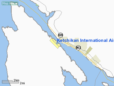
Ketchikan International Airport (IATA: KTN, ICAO: PAKT, FAA LID: KTN) is a state-owned public-use airport located one nautical mile (2 km) west of the central business district of Ketchikan, a city in Ketchikan Gateway Borough in the U.S. state of Alaska.
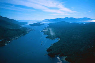
The airport is located on Gravina Island, just west of Ketchikan on the other side of the Tongass Narrows. Passengers must take a seven-minute ferry ride across the water to get to the airport from the town. History
Around the World War II era, air service to Ketchikan was possible using an old military airfield on Annette Island. Aircraft used in that era included the Grumman Goose and Catalina PBY. The current airport was opened on August 4, 1973 and dedicated the following day. The airport opening was the culmination of an effort by local residents, a 1965 study by the Alaska State Division of Aviation, another study in 1967 choosing the current site on Gravina Island, and land clearing in 1969.
Facilities and aircraft
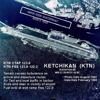
Ketchikan International Airport covers an area of 2,600 acres (1,052 ha) at an elevation of 88 feet (27 m) above mean sea level. It has one runway designated 11/29 with 7,500 x 150 ft (2,286 x 46 m) asphalt pavement. It also has a seaplane landing area designated NWW/SEW which measures 9,500 x 1,500 ft (2,896 x 457 m).
For the 12-month period ending January 1, 2006, the airport had 16,208 aircraft operations, an average of 44 per day: 60% air taxi, 33% scheduled commercial, 6% general aviation and 1% military. At that time there were 13 aircraft based at this airport: 77% single-engine, 8% multi-engine and 15% helicopter.
In 2004, a new taxiway "Bravo" was added to facilitate taxiing to the end of the frequently used runway 11 (the runway is located about 30 feet (9.1 m) higher than the apron further up the hillside, requiring long, gently sloped taxiways to either end). Before that taxiway, some smaller planes were allowed to use taxiway "Alpha" to take off and land because it was not worthwhile to backtaxi on the actual runway. In addition this allows the airport's system of taxiways to be used by more than one plane at once. More recently the airport is applying to construct another runway on a different heading which is better suited to handle the infamous crosswinds, sometimes up to 90 knots (170 km/h). These winds have been known to blow approaching planes out across Tongass Narrows in certain conditions.
Proposed road accessThere is no road access between Ketchikan and the airport. A bridge, sometimes referred to "bridge to nowhere", was proposed costing an estimated $398 million. After protracted attention to the high cost of the bridge, the U.S. federal government changed its original decision to fund the bridge in 2007. The money was transferred to the state of Alaska to determine the use of the funds.
Airlines and destinations
Scheduled passenger service
| Airlines |
Destinations |
| Alaska Airlines |
Juneau, Seattle/Tacoma, Sitka, Wrangell |
| Pacific Airways |
Craig, Hollis, Metlakatla, Thorne Bay |
| Promech Air |
Craig, Hollis, Metlakatla, Thorne Bay |
| Taquan Air |
Coffman Cove, Craig, Dora/Cholmondely Sound, Edna Bay, Hydaburg, Hyder, Metakatla, Mosier/Deep Bay, Naukati,Point Baker, Port Protection, Thorne Bay, Whale Pass |
Cargo Airlines
| Airlines |
Destinations |
| Ameriflight |
Seattle-Boeing, Vancouver |
Charter and flightseeing
- Family Air Tours
- Misty Fjords Air
- Pacific Airways
- SeaWind Aviation
- Southeast Aviation
Accidents
- An Alaska Airlines Boeing 727-100 overran the southern end of the runway on April 5, 1976. The aircraft was trying to land, but the braking seemed sluggish after the fast landing, so the pilot decided to perform a go around. The thrust reversers on the engines didn't fully disengage, so the engines did not rev up enough to allow a takeoff. The pilot aborted the takeoff and the aircraft overran the runway by 700 feet (210 m). One of the 50 passengers died.
The above content comes from Wikipedia and is published under free licenses – click here to read more.
Ketchikan International Airport Mission Statement:
Our Mission is to provide and promote safe, dependable
and efficient transportation infrastructure and services for the general
public.
Our contact information is as follows:
Transportation Services
1000 Airport Terminal Building, Suite 10
Ketchikan, Alaska
907-225-6800
Ketchikan
International Airport Short History:
The Ketchikan International Airport was jointly constructed by
the Ketchikan Gateway Borough, the State of Alaska, Department of Public
Works and the Federal Aviation Administration to serve the residents of
Ketchikan and Southeast Alaska, the Airport was dedicated on August 4
- 5, 1973.
AIRPORT
HISTORY:
 Airplanes
must have airports - just as ships require docks and trains need railroad
stations. An airport provides a place for planes to take off and land.
It also includes areas in which aircraft are loaded, unloaded, fueled,
repaired and stored. Airports vary in size. The large ones used by airlines
utilizing jet transports are called "air carrier" airports.
The smaller activities that serve mostly private planes are known as general
aviation airports. Airports are classed according to the size of the aircraft
that use the airport, and the frequency of those flights per day. Classification
is by letter designation, A, B, C, or D. Index "A" is the smallest,
and index "D" being the largest. Ketchikan is classed as an
index "B" airport. Airplanes
must have airports - just as ships require docks and trains need railroad
stations. An airport provides a place for planes to take off and land.
It also includes areas in which aircraft are loaded, unloaded, fueled,
repaired and stored. Airports vary in size. The large ones used by airlines
utilizing jet transports are called "air carrier" airports.
The smaller activities that serve mostly private planes are known as general
aviation airports. Airports are classed according to the size of the aircraft
that use the airport, and the frequency of those flights per day. Classification
is by letter designation, A, B, C, or D. Index "A" is the smallest,
and index "D" being the largest. Ketchikan is classed as an
index "B" airport.
Ketchikan International
Airport has four main types of facilities. One is for transporting passengers
and freight to and from the airport (Ferry System), one is for passengers
arriving and departing (Airport Terminal), one is for planes on the ground,
(Aircraft Ramp and Parking Areas), and one is for aircraft that are taking
off or landing (Runway).
The history of
Ketchikan International Airport starts before W.W.II. Air travel to Ketchikan
was via Grumman Goose from the old military airfield on Annette Island.
Many Ketchikan residents wanted an airport closer to Ketchikan and in
1965 the Alaska State Division of Aviation contracted for a site study
of the areas around Ketchikan. In 1967 another more detailed study was
done and Gravina Island was chosen as the best site. Clearing the land
began in 1969. The runway, taxiway and aircraft parking areas were funded
by State and Federal money, and Ketchikan Gateway Borough voters approved
a bond for the Terminal building, utilities and related facilities. The
official opening dedication for Ketchikan International Airport was August
4 & 5, 1973.
Location & QuickFacts
|
FAA
Information Effective: |
2006-02-16 |
|
Airport Identifier: |
KTN |
|
Longitude/Latitude: |
131-42-49.5000W/55-21-20.0000N
-131.713750/55.355556 (Estimated) |
|
Elevation: |
88
ft / 26.82 m (Surveyed) |
|
Land: |
2600
acres |
|
From nearest
city: |
1
nautical miles W of Ketchikan, AK |
|
Location: |
Ketchikan
County, AK |
|
Magnetic
Variation: |
26E
(1985) |
Owner & Manager
|
Ownership: |
Publicly
owned |
|
Owner: |
State
Of Ak Dotpf Se Rgn |
|
Address: |
6860
Glacier Highway
Juneau, AK 99801-7999 |
|
Phone number: |
907-465-1786 |
|
Manager: |
Mike
Carney |
|
Address: |
1000
Arpt Terminal Way
Ketchikan, AK 99901 |
|
Phone number: |
907-225-6800 |
Airport Operations
and Facilities
|
Airport
Use: |
Open to
public |
|
Wind indicator: |
Yes |
|
Segmented
Circle: |
Yes |
|
Control Tower: |
No |
|
Attendance
Schedule: |
SEP-MAY/ALL/0600-2130,JUN-AUG/ALL/0600-2200 |
|
Lighting
Schedule: |
RDO-CTL
FOR ROTG BCN CTC KTN FSS. |
|
Beacon Color: |
Clear-Green
(lighted land airport) |
|
Landing fee
charge: |
Yes
NO LNDG FEE FOR GA ACFT UNDER 6000 LBS ON RY. $2.00 PER
FLOAT PLANE FOR USE OF SPB FLOAT. |
|
Sectional
chart: |
Ketchikan |
|
Region: |
AAL
- Alaska |
|
Boundary
ARTCC: |
ZAN
- Anchorage |
|
Tie-in FSS: |
KTN
- Ketchikan |
|
FSS on Airport: |
Yes |
|
FSS Phone: |
907-225-9481 |
|
FSS Toll
Free: |
LC225-9481 |
|
NOTAMs Facility: |
KTN
(NOTAM-d service avaliable) |
|
Certification
type/date: |
I
BS 6/1973 |
|
Federal Agreements: |
NGY |
Airport Communications
|
CTAF: |
123.600 |
|
Unicom: |
122.950
|
Airport Services
|
Fuel
available: |
100LLA
FUEL AVBL AT 122.95 OR CALL 907-247-5701 FM 0700-2000L WEEKDAY
AND 0700-1800L WEEKEND(WINTER) & 0600-2100 WEEEKDAY
AND 0600-2000 WEEKEND(SUMMER). |
|
Runway Information
Runway 11/29
|
Dimension: |
7500 x 150 ft /
2286.0 x 45.7 m |
|
Surface: |
ASPH,
Good Condition |
|
Surface Treatment: |
Saw-cut
or plastic Grooved |
|
Weight Limit: |
Single wheel: 75000 lbs.
Dual wheel: 200000 lbs.
Dual tandem wheel: 300000 lbs. |
|
Edge Lights: |
High |
|
|
Runway 11 |
Runway 29 |
|
Longitude: |
131-43-34.8302W |
131-42-04.0707W |
|
Latitude: |
55-21-46.3723N |
55-20-53.5481N |
|
Elevation: |
79.00 ft |
86.00 ft |
|
Alignment: |
127 |
127 |
|
ILS Type: |
ILS/DME |
|
|
Traffic Pattern: |
Right |
Left |
|
Markings: |
Nonstandard, Good Condition
SIZE AND SPACING OF MARKINGS NSTD. |
Nonstandard, Good Condition
SIZE AND SPACING OF MARKINGS NSTD. |
|
Crossing Height: |
0.00 ft |
52.00 ft |
|
VASI: |
4-light PAPI on left side
PAPI UNUSBL BYD 5 DEGS R OF COURSE. |
4-box on left side |
|
Visual Glide
Angle: |
0.00� |
3.00� |
|
Approach lights: |
MALSF |
MALSR |
|
Obstruction: |
103 ft trees, 3300.0 ft from runway, 30:1 slope
to clear |
,
50:1 slope to clear |
|
Runway NWW/SEW
|
Dimension: |
9500 x 1500 ft /
2895.6 x 457.2 m |
|
Surface: |
WATER,
|
|
|
Runway NWW |
Runway SEW |
|
Traffic Pattern: |
Left |
Left |
|
Radio Navigation Aids
|
ID |
Type |
Name |
Ch |
Freq |
Var |
Dist |
|
CMJ |
NDB |
Clam
Cove |
|
396.00 |
27E |
0.9
nm |
|
ICK |
NDB |
Nichols |
|
266.00 |
27E |
17.5
nm |
|
AKW |
NDB/DME |
Klawock |
105X |
229.00 |
24E |
48.3
nm |
|
ANN |
VORTAC |
Annette Island |
118X |
117.10 |
27E |
18.3
nm |
|
ECH |
VOT |
Ketchikan |
|
111.00 |
|
0.5
nm |
Remarks
- TERRAIN
CAUSES TURBULENCE ON ARR & DEP ROUTES.
- THE
NGS SURVEY DATED 4 AUG 2001 FOR THIS ARPT AND ASSOCIATED NAVAIDS IS
UNDER REVIEW.
- BE
ALERT: SEE REGULATORY NOTICE - KETCHIKAN INTERNATIONAL AIRPORT SPECIAL
AIR TRAFFIC RULES AND AIRPORT TRAFFIC PATTERNS.
- NO
LNDG FEE FOR GA ACFT UNDER 6000 LBS ON RY. LNDG FEE FOR FLOAT PLANE
FOR USE OF SPB FLOAT AND FOR MUTI-ENGINE ACFT.
- USCG
HELIPAD LCTD AT 55-21-27.6N 131-42-19.8W INVOF KETCHIKAN INTL ARPT &
SEAPLAN BASE. HELIPAD IS FOR USCG MED-VAC MISSIONS ONLY.POC IS COMMANDER
CG DISTRICT 17, 709 W 9TH ST, RM 661. BOX 25517 JUNEAU, AK 99802. 907-463-2247/2000.
- SPECIAL
AIR TFC RULES PART 93 AND STANDARD VFR ARRIVAL AND DEPARTURE PROCEDURES
AND PATTERNS INFORMATION; SEE REGULATORY NOTICES.
- FERRY
BTN ARPT & CITY OPERATES CONTINUALLY WHILE ARPT ATTENDED.
- BIRDS
ON & INVOF ARPT.
- ALL
ACFT: PRIOR TO OPERG ON APRON/TWY CTC KETCHIKAN FSS & ADVISE INTENTIONS.
- SFC
COND RPRTS REFLECT CONDS WHILE ARPT ATNDD ONLY.
- AIR
TAXI & BOAT TRAFFIC IN HARBOR. FLOATING DEBRIS MAY BE IN WATER WAY.
- NO
SNOW OR ICE REMOVAL WHEN ARPT NOT ATTND.
Based Aircraft
|
Aircraft
based on field: |
13 |
|
Single
Engine Airplanes: |
10 |
|
Multi
Engine Airplanes: |
1 |
|
Helicopters: |
2 |
Major Carriers
Serving This Airport
Most Popular Destinations
| Seattle-tacoma Intl (SEA) |
50.4% |
| Juneau Intl (JNU) |
16.5% |
| Sitka Rocky Gutierrez (SIT) |
16.5% |
| Wrangell (WRG) |
16.5% |
Most Popular Aircraft
|
N706AS |
4.0% |
| N756AS |
3.6% |
|
N763AS |
3.6% |
| N775AS |
3.4% |
|
N771AS |
3.4% |
| N708AS |
3.1% |
|
N796AS |
2.9% |
| N778AS |
2.9% |
|
N788AS |
2.7% |
| N769AS |
2.5% |
Operational Statistics
|
Aircraft
Operations: |
59/Day |
|
Air Carrier: |
24.6% |
|
Air Taxi: |
45.5% |
|
General
Aviation Local: |
1.9% |
|
General
Aviation Itinerant: |
2.7% |
|
Military: |
0.7% |
Ketchikan International Airport
Address: Ketchikan
County, AK
Tel:
907-465-1786,
907-225-6800
URL:
http://www.borough.ketchikan.ak.us/airport/airport.htm
Fax: 907-225-2939
E-mail: airport@borough.ketchikan.ak.us
Images
and information placed above are from
http://www.airport-data.com/airport/KTN/
http://www.borough.ketchikan.ak.us/airport/airport.htm
We
thank them for the data!
| General
Info |
| Country |
United
States |
| State |
ALASKA
|
| FAA ID |
KTN
|
| Latitude |
55-21-20.000N
|
| Longitude |
131-42-49.500W
|
| Elevation |
97 feet
|
| Near City |
KETCHIKAN
|
We don't guarantee the information is fresh and accurate. The data may
be wrong or outdated.
For more up-to-date information please refer to other sources.
|
|