|
|
Ketchikan Harbor Seaplane Base |
| Ketchikan Harbor Seaplane Base |
 |
| IATA: WFB – ICAO: none – FAA LID: 5KE |
| Summary |
| Airport type |
Public |
| Owner |
Public Domain |
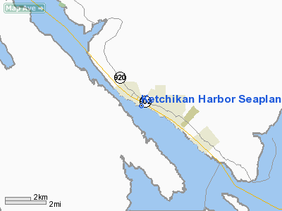
| Location |
Ketchikan, Alaska |
| Elevation AMSL |
0 ft / 0 m |
| Coordinates |
55°20′40″N 131°39′48″W / 55.34444°N 131.66333°W / 55.34444; -131.66333 |
| Runways |
| Direction |
Length |
Surface |
| ft |
m |
| NW/SE |
10,000 |
3,048 |
Water |
| Statistics (2006) |
| Enplanements |
29,878 |
| Aircraft operations |
10,450 |
| Based aircraft |
51 |
| Source: Federal Aviation Administration |
Ketchikan Harbor Seaplane Base (IATA: WFB, FAA LID: 5KE) is located in the harbor of Ketchikan, a city in the Ketchikan Gateway Borough of the U.S. state of Alaska.
As per Federal Aviation Administration records, this seaplane base had 37,252 passenger boardings (enplanements) in calendar year 2005 and 29,878 enplanements (5,365 scheduled and 24,513 unscheduled) in 2006. Facilities and aircraft
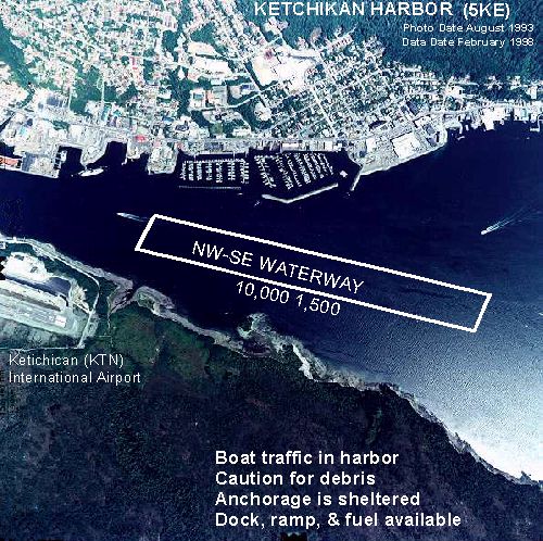
Ketchikan Harbor Seaplane Base has one seaplane landing area designated NW/SE which measures 10,000 x 1,500 ft. (3,048 x 457 m). For the 12-month period ending December 31, 2006, the airport had 10,450 aircraft operations, an average of 28 per day. At that time there were 51 aircraft based at this airport.
Airlines and scheduled destinations
- Taquan Air (Coffman Cove, Craig/Klawock, Deep Bay [Moser Bay], Dora/Cholmondely Sound, Edna Bay, Grace Harbor/Long Island, Hydaburg, Hyder, Metakatla, Naukati, Point Baker, Port Protection, Thorne Bay, Whale Pass)
The above content comes from Wikipedia and is published under free licenses – click here to read more.
Location & QuickFacts
|
FAA
Information Effective: |
2006-02-16 |
|
Airport Identifier: |
5KE |
|
Longitude/Latitude: |
131-40-36.0700W/55-20-59.7500N
-131.676686/55.349931 (Estimated) |
|
Elevation: |
0
ft / 0.00 m (Estimated) |
|
Land: |
0
acres |
|
From nearest
city: |
0
nautical miles W of Ketchikan, AK |
|
Location: |
Ketchikan
County, AK |
|
Magnetic
Variation: |
26E
(1985) |
Owner & Manager
|
Ownership: |
Publicly
owned |
|
Owner: |
Public
Domain |
|
Address: |
|
|
Address: |
|
Airport Operations
and Facilities
|
Airport
Use: |
Open to
public |
|
Wind indicator: |
Yes |
|
Segmented
Circle: |
No |
|
Control Tower: |
No |
|
Attendance
Schedule: |
ALL/ALL/DALGT |
|
Landing fee
charge: |
No |
|
Sectional
chart: |
Ketchikan |
|
Region: |
AAL
- Alaska |
|
Boundary
ARTCC: |
ZAN
- Anchorage |
|
Tie-in FSS: |
KTN
- Ketchikan |
|
FSS on Airport: |
No |
|
FSS Phone: |
907-225-9481 |
|
FSS Toll
Free: |
LC225-9481 |
|
NOTAMs Facility: |
KTN
(NOTAM-d service avaliable) |
Airport Communications
|
CTAF: |
123.600 |
|
Unicom: |
122.950
|
Airport Services
|
Fuel
available: |
100 A
FUEL AVBL JUN 1 - SEP 30 0500-2000; OCT 1 - MAY 31 0700-1800. |
|
Airframe
Repair: |
MAJOR |
|
Power
Plant Repair: |
MAJOR |
|
Bottled Oxygen: |
NONE |
|
Bulk Oxygen: |
NONE |
|
Runway Information
Runway NW/SE
|
Dimension: |
10000 x 1500 ft
/ 3048.0 x 457.2 m |
|
Surface: |
WATER,
|
|
|
Runway NW |
Runway SE |
|
Traffic Pattern: |
Left |
Left |
|
Markings: |
None, |
None, |
|
Runway End
Identifier: |
No |
No |
|
Centerline
Lights: |
No |
No |
|
Touchdown Lights: |
No |
No |
|
Radio Navigation Aids
|
ID |
Type |
Name |
Ch |
Freq |
Var |
Dist |
|
CMJ |
NDB |
Clam
Cove |
|
396.00 |
27E |
0.7
nm |
|
ICK |
NDB |
Nichols |
|
266.00 |
27E |
17.0
nm |
|
AKW |
NDB/DME |
Klawock |
105X |
229.00 |
24E |
49.6
nm |
|
ANN |
VORTAC |
Annette Island |
118X |
117.10 |
27E |
17.7
nm |
|
ECH |
VOT |
Ketchikan |
|
111.00 |
|
0.9
nm |
Remarks
- BOAT
TRAFFIC & DEBRIS IN HARBOR.
- VARIOUS
AIR TAXI OPNS IN HARBOR.
- SPECIAL
AIR TRAFFIC RULES-PART 93 AND STANDARD VFR ARR & DEP PROCEDURES
AND PATTERN INFORMATION, SEE REGULATORY NOTICES.
Based Aircraft
|
Aircraft
based on field: |
20 |
|
Single Engine Airplanes: |
20 |
Operational Statistics
|
Aircraft
Operations: |
242/Day |
|
Air Taxi: |
85.2% |
|
General Aviation
Local: |
11.4% |
|
General Aviation
Itinerant: |
3.4% |
Ketchikan Harbor Seaplane Base
Address: Ketchikan
County, AK
Tel:
Images
and information placed above are from
http://www.airport-data.com/airport/5KE/
We
thank them for the data!
| General
Info |
| Country |
United
States |
| State |
ALASKA
|
| FAA ID |
5KE
|
| Latitude |
55-20-59.750N
|
| Longitude |
131-40-36.070W
|
| Elevation |
0 feet
|
| Near City |
KETCHIKAN
|
We don't guarantee the information is fresh and accurate. The data may
be wrong or outdated.
For more up-to-date information please refer to other sources.
|
|