|
|
| Kake Airport |
 |
| IATA: none – ICAO: PAFE – FAA LID: AFE |
| Summary |
| Airport type |
Public |
| Owner |
State of Alaska DOT&PF - Southeast Region |
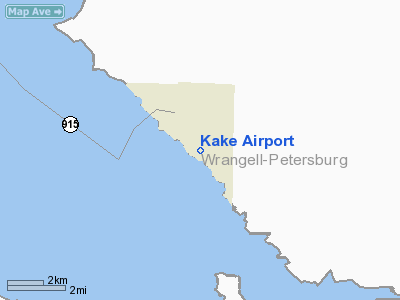
| Location |
Kake, Alaska |
| Elevation AMSL |
172 ft / 52 m |
| Coordinates |
56°57′41″N 133°54′37″W / 56.96139°N 133.91028°W / 56.96139; -133.91028 |
| Runways |
| Direction |
Length |
Surface |
| ft |
m |
| 10/28 |
4,000 |
1,219 |
Asphalt |
| Statistics (2003) |
| Aircraft operations |
4,600 |
| Based aircraft |
4 |
| Source: Federal Aviation Administration |
Kake Airport (ICAO: PAFE, FAA LID: AFE) is a public airport located in Kake, a city in the Wrangell - Petersburg Census Area of the U.S. state of Alaska. It is owned by the state, which also owns a nearby seaplane landing area known as Kake Seaplane Base (IATA: KAE, FAA LID: KAE). Facilities and aircraft
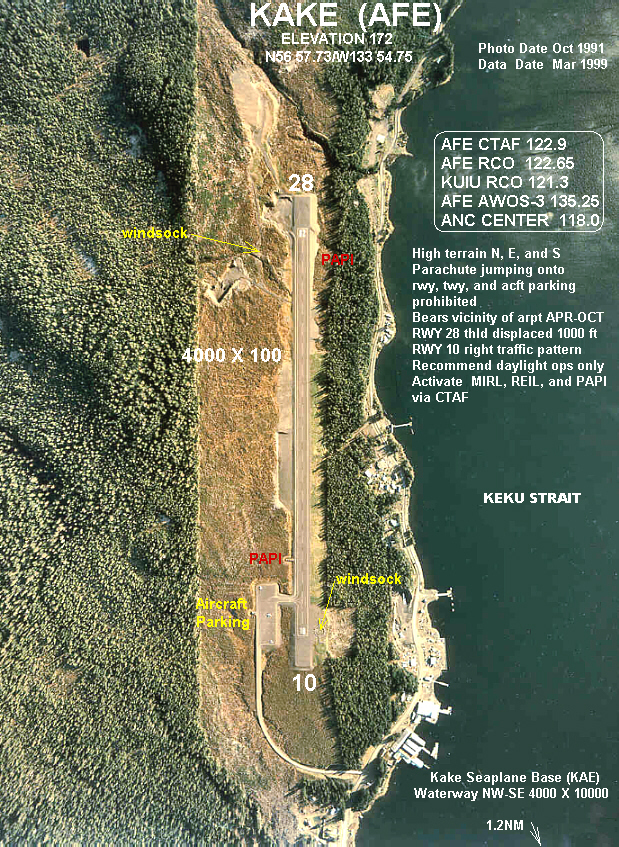
Kake Airport has one asphalt paved runway (10/28) measuring 4,000 x 100 ft. (1,219 x 30 m). For the 12-month period ending December 31, 2003, the airport had 4,600 aircraft operations, an average of 12 per day: 100% of which were air taxi flights.
Airline and destination
Commercial air service is subsidized by the Essential Air Service program.
The above content comes from Wikipedia and is published under free licenses – click here to read more.
Location & QuickFacts
|
FAA
Information Effective: |
2006-02-16 |
|
Airport Identifier: |
AFE |
|
Longitude/Latitude: |
133-54-36.9400W/56-57-40.9050N
-133.910261/56.961362 (Estimated) |
|
Elevation: |
172
ft / 52.43 m (Estimated) |
|
Land: |
0
acres |
|
From nearest
city: |
1
nautical miles W of Kake, AK |
|
Location: |
Wrangell-petersburg
County, AK |
|
Magnetic
Variation: |
27E
(1985) |
Owner & Manager
|
Ownership: |
Publicly
owned |
|
Owner: |
State
Of Ak Dotpf Se Reg |
|
Address: |
6860
Glacier Hwy
Juneau, AK 99801-7999 |
|
Phone number: |
907-465-1786 |
|
Manager: |
Michael
Binkie |
|
Address: |
6860
Glacier Hwy
Juneau, AK 99801-7999 |
|
Phone number: |
907-465-1786 |
Airport Operations
and Facilities
|
Airport
Use: |
Open to
public |
|
Wind indicator: |
Yes |
|
Segmented
Circle: |
Yes |
|
Control Tower: |
No |
|
Attendance
Schedule: |
UNATNDD |
|
Lighting
Schedule: |
RDO-CTL
ACTVT MIRL RY 10/28; PAPI RYS 10 & 28; REIL RY 10 -
CTAF. |
|
Sectional
chart: |
Juneau |
|
Region: |
AAL
- Alaska |
|
Boundary
ARTCC: |
ZAN
- Anchorage |
|
Tie-in FSS: |
SIT
- Sitka |
|
FSS on Airport: |
No |
|
FSS Phone: |
907-966-2221 |
|
FSS Toll
Free: |
1-478-6300 |
|
Alternate
FSS: |
JNU
- Juneau |
|
Alt. FSS
Toll Free: |
1-800-WX-BRIEF |
|
NOTAMs Facility: |
AFE
(NOTAM-d service avaliable) |
|
Federal Agreements: |
N |
Airport Communications
|
Runway Information
Runway 10/28
|
Dimension: |
4000 x 100 ft /
1219.2 x 30.5 m |
|
Surface: |
ASPH,
Good Condition |
|
Edge Lights: |
Medium |
|
|
Runway 10 |
Runway 28 |
|
Longitude: |
133-55-04.6200W |
133-54-09.2600W |
|
Latitude: |
56-57-53.5400N |
56-57-28.2700N |
|
Elevation: |
150.00 ft |
172.00 ft |
|
Alignment: |
127 |
127 |
|
Traffic Pattern: |
Right |
Left |
|
Markings: |
Basic, |
Basic, |
|
Crossing Height: |
35.00 ft |
40.00 ft |
|
Displaced threshold: |
0.00 ft |
1000.00 ft |
|
VASI: |
4-light PAPI on left side |
4-light PAPI on left side |
|
Visual Glide
Angle: |
3.00� |
3.50� |
|
Runway End
Identifier: |
Yes |
|
|
Obstruction: |
50 ft trees, 1200.0 ft from runway, 20:1 slope
to clear |
200 ft hill, 2400.0 ft from runway, 11:1 slope
to clear
APCH SLOPE 26:1 TO DSPLCD THLD. |
|
Radio Navigation Aids
|
ID |
Type |
Name |
Ch |
Freq |
Var |
Dist |
|
FPN |
NDB |
Fredericks Point |
|
372.00 |
28E |
37.2
nm |
|
SQM |
NDB |
Sumner Strait |
|
529.00 |
28E |
40.1
nm |
|
IME |
NDB |
Mount
Edgecumbe |
|
414.00 |
28E |
47.9
nm |
|
AFE |
NDB/DME |
Kake |
091X |
223.00 |
26E |
0.2
nm |
|
LVD |
VOR/DME |
Level
Island |
112X |
116.50 |
28E |
40.3
nm |
Remarks
- ARPT
CONDITION NOT MONITORED, ARPT MAINT ON IREG BASIS, RECOMMEND VISUAL
INSPECTION PRIOR TO USING.
- RCMD
DALGT OPNS ONLY. HI TRRN N & E & S OF ARPT.
- SAFETY
AREA 4600' X 150'.
- BIRDS,
BEAR AND DEER ON AND INVOF RY.
- PARACHUTE
JUMPING ONTO ARPT RY; TWY & ACFT APRON PROHIBITED.
- PILOTS
ARE REQUESTED TO SELF-ANNOUNCE ON COMMON TRAFFIC ADVISORY FREQ (CTAF)
PRIOR TO TAXIING ON THE RY FOR DEPT; LEAVING THE RY AND WITHIN 5 NM
OF THE ARPT WHEN APPROACHING TO LAND.
- SHALLOW
DEPRESSIONS 4 IN DEEP 40 FT IN DIAM, 375 FT FM AER 28 N SIDE. SMALLER
SHALLOW DEPRESSIONS FULL LENGTH & WIDTH OF RY. STANDING WATER AFT
RAIN.
Based Aircraft
|
Aircraft
based on field: |
4 |
|
Single Engine Airplanes: |
4 |
Operational Statistics
|
Aircraft
Operations: |
89/Week |
|
Air Taxi: |
100.0% |
Kake Airport
Address: Wrangell-petersburg
County, AK
Tel:
907-465-1786
Images
and information placed above are from
http://www.airport-data.com/airport/AFE/
We
thank them for the data!
| General
Info |
| Country |
United
States |
| State |
ALASKA
|
| FAA ID |
AFE
|
| Latitude |
56-57-40.905N
|
| Longitude |
133-54-36.940W
|
| Elevation |
172 feet
|
| Near City |
KAKE
|
We don't guarantee the information is fresh and accurate. The data may be
wrong or outdated.
For more up-to-date information please refer to other sources.
|
|