|
|
Juneau International Airport |
Coordinates: 58°21′18″N 134°34′35″W / 58.355°N 134.57639°W / 58.355; -134.57639
| Juneau International Airport |
 |
| IATA: JNU – ICAO: PAJN – FAA LID: JNU |
| Summary |
| Airport type |
Public |
| Owner |
City and Borough of Juneau, Alaska |
| Serves |
Juneau, Alaska |
| Elevation AMSL |
21 ft / 6 m |
| Website |
www.juneau.org/airport/ |
| Runways |
| Direction |
Length |
Surface |
| ft |
m |
| 8/26 |
8,457 |
2,578 |
Asphalt |
| 8W/26W |
4,900 |
1,494 |
Water |
| Statistics (2006) |
| Aircraft operations |
153,010 |
| Based aircraft |
341 |
| Source: Federal Aviation Administration |
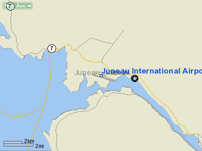
Juneau International Airport (IATA: JNU, ICAO: PAJN, FAA LID: JNU) is a public airport located seven miles (11 km) northwest of the central business district of Juneau, a city and borough in the U.S. state of Alaska. The airport serves as a regional hub for all air travel, both bush carriers and the regional airline, Alaska Airlines. Facilities and aircraft
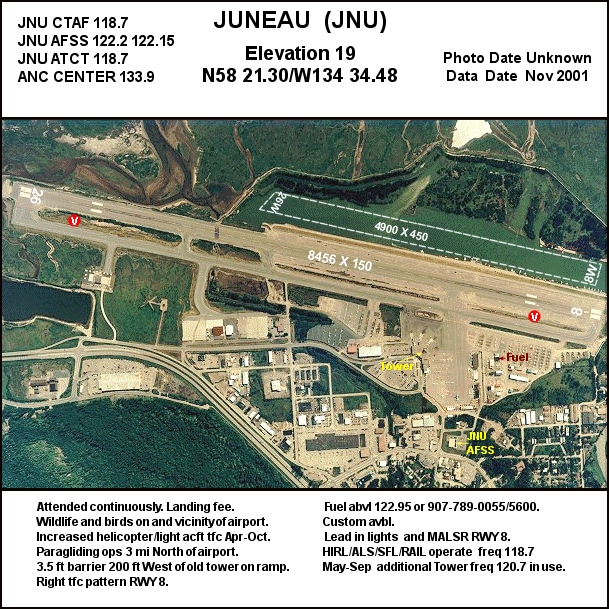
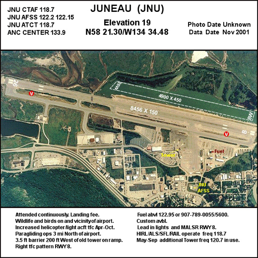
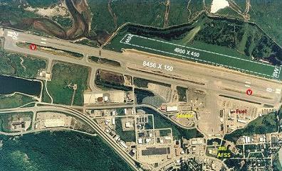
Juneau International Airport covers an area of 653 acres (264 ha) and contains one runway designated 8/26 with 8,457 x 150 ft (2,578 x 46 m) asphalt pavement. It also has a seaplane landing area designated 8W/26W which measures 4,900 x 450 ft (1,494 x 137 m).
For the 12-month period ending December 15, 2006, the airport had 153,010 aircraft operations, an average of 419 per day: 70% air taxi, 24% general aviation, 5% scheduled commercial and 1% military. There are 341 aircraft based at this airport: 82% single-engine, 10% helicopter, 6% multi-engine, 1% military, <1% jet and <1% ultralight.
Location and controversy
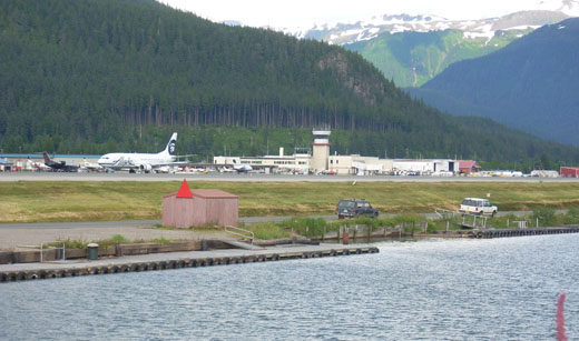 | |
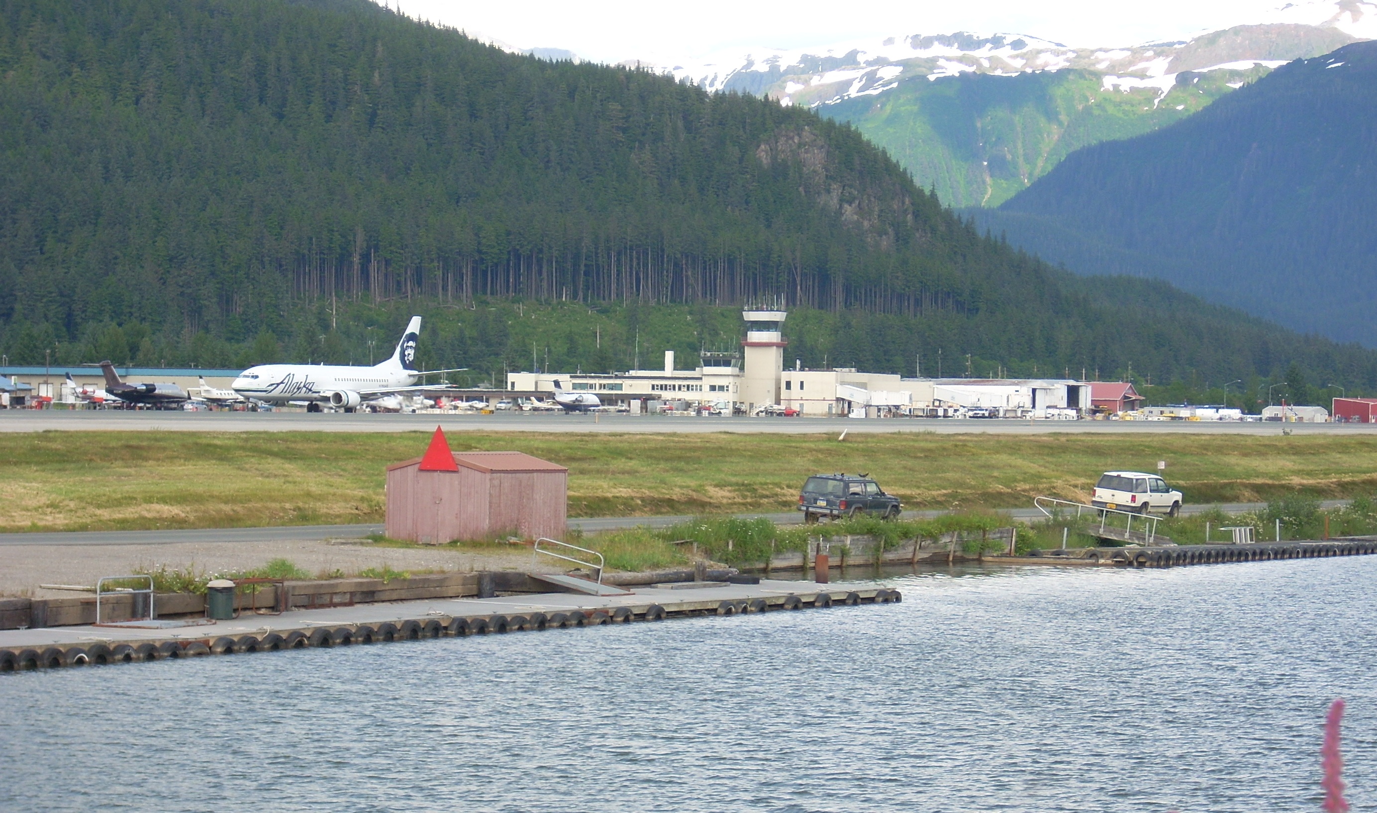
JNU Terminal. |
Because of the extreme geography of Southeastern Alaska, land flat enough for airport facilities is at a premium. One of these few areas is the current location of the airport: the Mendenhall Wetlands State Game Refuge, a vastly diverse and ecologically critical region rich with plant life, small mammals, birds, several species of salmon, even Black bears and Bald Eagles. The original airstrip was built in the 1930s, and no environmental impact analysis was performed at that time. The area currently housing the terminal and runways had to be filled in and part of the Gastineau Channel had to be dredged before the airport, in its current incarnation, could be built. The airport is the only way in and out of the city, with exception of the Alaska Marine Highway and cargo ships traversing the Inside Passage. In the past, concerns have been raised over the safety of the airport, which is comparatively quite small, with the amount of air traffic it receives. In addition to frequent arrivals and departures from hubs such as Anchorage and Seattle/Tacoma, the airport also has daily and/or weekly service to smaller regional communities, a floatplane runway/docking area, and a heliport. Three major construction projects are planned at the airport in the next few years. An airport terminal renovation project will be the first comprehensive upgrade to the passenger facilities in over twenty years and will provide for better flow through the passenger screening process. The airfield maintenance facilities project will provide much needed room for storage and servicing of snow removal equipment. The runway safety area project will extend the runway at both ends and improve taxiways to meet Federal Aviation Administration requirements.
Airlines and destinations
| Airlines |
Destinations |
| Alaska Airlines |
Anchorage, Cordova, Gustavus [seasonal], Ketchikan, Petersburg, Seattle/Tacoma, Sitka, Yakutat |
| Alaska Seaplane Service |
Angoon, Elfin Cove, Pelican, Tenakee Springs |
| Ward Air |
Chatham, Funter Bay |
| Wings of Alaska |
Excursion Inlet, Gustavus, Haines, Hoonah, Skagway |
World War II
During the war, Juneau Airport was used by the United States Army Air Force as a transport link between the combat bases being established in the Aleutians and airfields in the Continental United States. It was also used by Air Transport Command and facilitated the transport of Lend-Lease aircraft to the Soviet Union via Nome (Marks Army Airfield).
Incidents
On September 4, 1971, Alaska Airlines Flight 1866, a Boeing 727 crashed into the easterly slope of a canyon in the Chilkat Range of the Tongass National Forest while on approach to Juneau International Airport. All 111 passengers and crew on board were killed. At the time it was the worst single airplane air disaster in United States history.
The above content comes from Wikipedia and is published under free licenses – click here to read more.
Juneau, the Capitol of Alaska, is located
roughly 890 miles northwest of Seattle, Washington and 560 miles southeast
of Anchorage, Alaska in the "Alaskan Panhandle.
Juneau International Airport.
Juneau, the Capitol of Alaska, is located roughly 890 miles northwest
of Seattle, Washington and 560 miles southeast of Anchorage, Alaska in
the "Alaskan Panhandle".

How the Airport is Governed:
The Juneau International Airport is a municipal airport. The airport is
a department of the City and Borough of Juneau (CBJ). A seven-person airport
board that is answerable to the CBJ Assembly governs the airport. The
airport board oversees the maintenance and operations of the airport;
fiscal responsibility vests with the CBJ Assembly. The airport board meets
on the second Wednesday of each month in the Airport Aurora Room.

Location & QuickFacts
|
FAA
Information Effective: |
2006-02-16 |
|
Airport Identifier: |
JNU |
|
Longitude/Latitude: |
134-34-34.6000W/58-21-17.9000N
-134.576278/58.354972 (Estimated) |
|
Elevation: |
21
ft / 6.40 m (Surveyed) |
|
Land: |
653
acres |
|
From nearest
city: |
7
nautical miles NW of Juneau, AK |
|
Location: |
Juneau
County, AK |
|
Magnetic
Variation: |
28E
(1985) |
Owner & Manager
|
Ownership: |
Publicly
owned |
|
Owner: |
City
Of Juneau |
|
Address: |
155
S Seward
Juneau, AK 99801 |
|
Phone number: |
907-789-7821 |
|
Manager: |
Allan
Heese |
|
Address: |
1873
Shell Simmons Dr, Suite 201
Juneau, AK 99801 |
|
Phone number: |
907-789-7821 |
Airport Operations
and Facilities
|
Airport
Use: |
Open to
public |
|
Wind indicator: |
Yes |
|
Segmented
Circle: |
Yes |
|
Control Tower: |
Yes |
|
Attendance
Schedule: |
ALL/ALL/ALL |
|
Lighting
Schedule: |
DUSK-DAWN
FOR HIRL RY 08/26, MALSR RY 08 & REIL RY 26 CTC JNU
ATCT ON FREQ 118.7. WHEN ATCT CLSD CTC JNU AFSS ON FREQ
118.7. VASI RYS 08 & 26 OPER 24 HRS. |
|
Beacon Color: |
Clear-Green
(lighted land airport) |
|
Landing fee
charge: |
Yes |
|
Sectional
chart: |
Juneau |
|
Region: |
AAL
- Alaska |
|
Traffic Pattern
Alt: |
1500
ft |
|
Boundary
ARTCC: |
ZAN
- Anchorage |
|
Tie-in FSS: |
JNU
- Juneau |
|
FSS on Airport: |
Yes |
|
FSS Phone: |
907-586-7380 |
|
FSS Toll
Free: |
1-800-WX-BRIEF |
|
NOTAMs Facility: |
JNU
(NOTAM-d service avaliable) |
|
Certification
type/date: |
I
BS 5/1973 |
|
Federal Agreements: |
NGPSY |
Airport Communications
|
CTAF: |
118.700 |
|
Unicom: |
122.950
|
Airport Services
|
Fuel
available: |
100LL80
A1+
MILITARY CONTRACT FUEL AVBL. |
|
Airframe
Repair: |
MAJOR
AIRFRAME/POWER PLANT SVC FOR SINGLE/TWIN PROP ENG ACFT TURBIN
& AVIONICS. |
|
Power
Plant Repair: |
MAJOR |
|
Bottled Oxygen: |
NONE |
|
Bulk Oxygen: |
NONE |
|
Runway Information
Runway 08/26
|
Dimension: |
8457 x 150 ft /
2577.7 x 45.7 m |
|
Surface: |
ASPH,
Good Condition |
|
Surface Treatment: |
Saw-cut
or plastic Grooved |
|
Weight Limit: |
Single wheel: 75000 lbs.
Dual wheel: 200000 lbs.
Dual tandem wheel: 340000 lbs.
Dual dual tandem wheel: 500000 lbs. |
|
Edge Lights: |
High |
|
|
Runway 08 |
Runway 26 |
|
Longitude: |
134-35-51.2107W |
134-33-18.0024W |
|
Latitude: |
58-21-28.5487N |
58-21-07.1916N |
|
Elevation: |
21.00 ft |
20.00 ft |
|
Alignment: |
105 |
127 |
|
ILS Type: |
LDA/DME |
|
|
Traffic Pattern: |
Right |
Left |
|
Markings: |
Non-precision instrument, Fair Condition |
Non-precision instrument, Fair Condition |
|
Crossing Height: |
39.00 ft |
52.00 ft |
|
VASI: |
4-box on left side |
4-box on right side
VASI USABLE ONLY WITHIN 2 NM. |
|
Visual Glide
Angle: |
3.00� |
3.00� |
|
RVR Equipment: |
touchdown, rollout |
touchdown, rollout |
|
Approach lights: |
MALSR
LDIN LGTS. |
|
|
Runway End
Identifier: |
|
Yes |
|
Obstruction: |
573 ft tower, 7600.0 ft from runway, 900 ft
left of centerline, 12:1 slope to clear |
,
50:1 slope to clear |
|
Runway 08W/26W
|
Dimension: |
4900 x 450 ft /
1493.5 x 137.2 m |
|
Surface: |
WATER,
|
|
|
Runway 08W |
Runway 26W |
|
Traffic Pattern: |
Left |
Left |
|
Radio Navigation Aids
|
ID |
Type |
Name |
Ch |
Freq |
Var |
Dist |
|
JDL |
FAN
MARKER |
Lynns |
|
|
29E |
16.0
nm |
|
MND |
NDB |
Mendenhall |
|
332.00 |
29E |
1.8
nm |
|
CGL |
NDB |
Coghlan Island |
|
212.00 |
29E |
3.9
nm |
|
EEF |
NDB |
Elephant |
|
391.00 |
29E |
24.2
nm |
|
GAV |
NDB |
Gustavus |
|
219.00 |
25E |
35.8
nm |
|
SSR |
VORTAC |
Sisters Island |
087X |
114.00 |
29E |
24.1
nm |
|
JNU |
VOT |
Juneau |
|
111.00 |
|
3.2
nm |
Remarks
- 6
FT FENCE 200 FT W OF OLD ATCT ON RAMP.
- FOR
A LOCAL CALL TO JNU AFSS CALL 907-789-7380.
- TRANSIENT
DOCK AVBL FOR PUBLIC USE FOR UP TO SIX ACFT, SW CORNER.
- SEE
SPECIAL NOTICES AND GENEWRAL NOTICES FOR ADDITIONAL INFORMATION ON OPNS
IN JUNEAU AREA.
- BE
ALERT; COMPASS ROSE UNUSBL INDEFLY.
- LENA
POINT, PEDERSON HILL AND SISTERS ISLAND WX CAMERAS AVBL ON INTERNET
AT HTTP://AKWEATHERCAMS.FAA.GOV
- NATIONAL
GUARD 24 HR PPR DUE TO LIMITED PARKING C907-789-3366. 0730-1600 WEEKDAYS
CONTACT GUARD OPS 10 MIN PRIOR TO LANDING ON 124.65.
- WILDLIFE
& BIRDS ON & INVOF ARPT.
- BATTLESHIP
ISLAND LDIN GROUPING; CENTER LIGHT 582132.88N 1344012.22W. IJDL-LOCALIZER
LDIN GROUPING; CENTER LIGHT 582132.02N 1343810.39W.
- INCREASED
HELICOPTER/LIGH ACFT ACTIVITY APR 15-OCT 1 ENTIRE LENGTH ON GASTINEAU
CHANNEL & WITHIN 5 MILES OF ARPT.
- PARAGLIDING
ACTIVITY 3 MILES N OF ARPT INVOF THUNDER MOUNTAIN & OVER GASTINEAU
CHANNEL NEARS DOWNTOWN APR 15-OCT 1 6000 FT & BLO.
- TPA
1500 AGL FOR LARGE TURBINE ACFT; 1000 FT AGL FOR FIXED WING ACFT; 500
FT AGL FOR HELICOPTERS.
Based Aircraft
|
Aircraft
based on field: |
292 |
|
Single Engine Airplanes: |
234 |
|
Multi Engine Airplanes: |
21 |
|
Helicopters: |
34 |
|
Military: |
3 |
Major Carriers Serving This
Airport
Most Popular Destinations
| Ted Stevens Anchorage Intl (ANC) |
28.9% |
| Seattle-tacoma Intl (SEA) |
22.6% |
| Sitka Rocky Gutierrez (SIT) |
19.6% |
| Ketchikan Intl (KTN) |
9.6% |
| Petersburg James A Johnson (PSG) |
9.6% |
| Yakutat (YAK) |
9.6% |
Most Popular Aircraft
|
N706AS |
3.9% |
| N708AS |
3.5% |
|
N771AS |
3.4% |
| N763AS |
3.2% |
|
N778AS |
2.9% |
| N775AS |
2.8% |
|
N709AS |
2.8% |
| N796AS |
2.7% |
|
N773AS |
2.6% |
| N793AS |
2.6% |
Operational Statistics
|
Aircraft
Operations: |
443/Day |
|
Air Carrier: |
5.2% |
|
Air Taxi: |
66.2% |
|
General Aviation
Local: |
11.5% |
|
General Aviation
Itinerant: |
11.1% |
|
Military: |
0.8% |
Juneau International Airport
1873 Shell Simmons Dr., Ste. 200
Juneau, AK 99801
Tel:
907-789-7821
URL:
http://www.juneau.org/airport/
Fax: 907-789-122
Images
and information placed above are from
http://www.airport-data.com/airport/JNU/
http://www.juneau.org/airport/
http://www.jnu-eis.org/
http://en.wikipedia.org/wiki/Image:JNU-a.jpg
We
thank them for the data!
| General
Info |
| Country |
United
States |
| State |
ALASKA
|
| FAA ID |
JNU
|
| Latitude |
58-21-17.863N
|
| Longitude |
134-34-34.595W
|
| Elevation |
19 feet
|
| Near City |
JUNEAU
|
We don't guarantee the information is fresh and accurate. The data may be
wrong or outdated.
For more up-to-date information please refer to other sources.
|
|