|
|
| Iliamna Airport |
 |
| IATA: ILI – ICAO: PAIL – FAA LID: ILI |
| Summary |
| Airport type |
Public |
| Owner |
Alaska DOT&PF - Central Region |
| Serves |
Iliamna, Alaska |
| Elevation AMSL |
192 ft / 59 m |
| Coordinates |
59°45′14″N 154°54′39″W / 59.75389°N 154.91083°W / 59.75389; -154.91083 |
| Runways |
| Direction |
Length |
Surface |
| ft |
m |
| 7/25 |
5,086 |
1,550 |
Asphalt |
| 17/35 |
4,800 |
1,463 |
Asphalt |
| E/W |
2,998 |
914 |
Water |
| N/S |
2,892 |
881 |
Water |
| Statistics (2004) |
| Aircraft operations |
15,400 |
| Based aircraft |
18 |
| Source: Federal Aviation Administration |
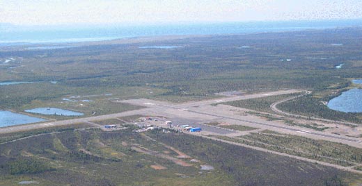
Iliamna Airport (IATA: ILI, ICAO: PAIL, FAA LID: ILI) is a state-owned public-use airport located three nautical miles (5.5 km) west of the central business district of Iliamna, in the Lake and Peninsula Borough of the U.S. state of Alaska. Facilities and aircraft
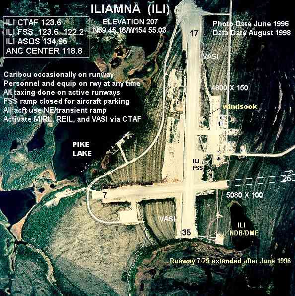
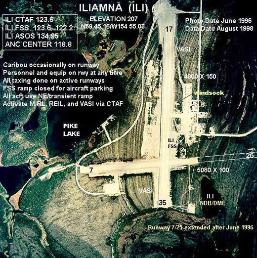
Iliamna Airport has two asphalt paved runways: 7/25 is 5,087 by 100 feet (1,551 x 30 m) and 17/35 is 4,800 by 100 feet (1,463 x 30 m). It also has two two seaplane landing areas: Runway E/W measures 2,998 x 400 ft. (914 x 122 m) and Runway N/S measures 2,892 x 400 ft. (881 x 122 m).
For the 12-month period ending December 31, 2004, the airport had 15,400 aircraft operations, an average of 42 per day: 73% general aviation and 27% air taxi. There are 18 aircraft based at this airport: 89% single engine and 11% multi-engine.
Airlines and destinations
| Airlines |
Destinations |
| Arctic Circle Air |
Anchorage |
| Iliamna Air Taxi |
Nondalton, Pedro Bay, Anchorage |
Incidents
- On August 30, 1975, Wien Air Alaska Flight 99 crashed on its approach to Iliamna airport. 10 of the 32 passengers and crew on board were killed.
The above content comes from Wikipedia and is published under free licenses – click here to read more.
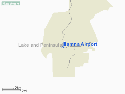
The Iliamna Airport is located in the
Lake and Peninsula Borough on the Alaskan Peninsula in southwest Alaska,
225 statute miles southwest of Anchorage. More specifically, it is on
the northwest side of Iliamna Lake near the communities of Iliamna and
Newhalen.
The airport is certified by the FAA as a Part 139 commercial
airport and classified as a Regional Airport in the Alaska Aviation System
Plan. As such, it serves as a hub connection to Anchorage for a number
of communities in the Iliamna Lake region. The primary runway (17/35)
is 150 feet wide by 4,800 feet long and the crosswind Runway (7/25) is
100 feet wide by 5,080 feet long. Both runways were paved in 2003. Among
the issues we feel the master plan will need to address with are:
- Airspace and Air Traffic management
- The need for additional lease lots and tie-down space
- Compliance with FAA runway visibility and taxiway safety
area standards
- Potential jet traffic due to airfield paving
- Snow removal and airport accessibility
- Land Use Compatibility
- Other issues identified by the public during the master
plan process
Location & QuickFacts
|
FAA
Information Effective: |
2006-02-16 |
|
Airport Identifier: |
ILI |
|
Longitude/Latitude: |
154-54-39.4550W/59-45-13.6810N
-154.910960/59.753800 (Estimated) |
|
Elevation: |
186
ft / 56.69 m (Surveyed) |
|
Land: |
0
acres |
|
From nearest
city: |
3
nautical miles W of Iliamna, AK |
|
Location: |
Bristol
Bay County, AK |
|
Magnetic
Variation: |
20E
(2000) |
Owner & Manager
|
Ownership: |
Publicly
owned |
|
Owner: |
State
Of Ak Dotpf-central Rgn |
|
Address: |
Pouch
196900
Anchorage, AK 99519-6900 |
|
Phone number: |
907-269-0767 |
|
Manager: |
John
Adcox |
|
Address: |
Po
Box 187
Iliamna, AK 99606 |
|
Phone number: |
907-571-1261 |
Airport Operations
and Facilities
|
Airport
Use: |
Open to
public |
|
Wind indicator: |
Yes |
|
Segmented
Circle: |
Yes |
|
Control Tower: |
No |
|
Attendance
Schedule: |
OCT-MAY/ALL/0800-1630,JUN-SEP/ALL/0800-1800 |
|
Lighting
Schedule: |
RDO-CTL
ACTVT MIRL RYS 07/25; 17/35; PAPI RYS 17, 35, 07, &
25; REIL RYS 25 & 35 - CTAF. |
|
Beacon Color: |
Clear-Green
(lighted land airport) |
|
Sectional
chart: |
Kodiak |
|
Region: |
AAL
- Alaska |
|
Boundary
ARTCC: |
ZAN
- Anchorage |
|
Tie-in FSS: |
ILI
- Iliamna |
|
FSS on Airport: |
Yes |
|
FSS Phone: |
907-571-1240 |
|
FSS Toll
Free: |
LC571-1240 |
|
Alternate
FSS: |
ENA
- Kenai |
|
Alt. FSS
Toll Free: |
1-800-WX-BRIEF |
|
NOTAMs Facility: |
ILI
(NOTAM-d service avaliable) |
|
Certification
type/date: |
I
AS 3/2005
CLSD TO ACR OPNS WITH MORE THAN 30 PSGR SEATS EXCP PPR IN
WRITING TO AMGR PO BOX 187 ILIAMNA; AK 99606. |
|
Federal Agreements: |
NGPY |
Airport Communications
Airport Services
|
Fuel
available: |
100LLA |
|
Airframe
Repair: |
NONE |
|
Power
Plant Repair: |
NONE |
|
Bottled Oxygen: |
NONE |
|
Bulk Oxygen: |
NONE |
|
Runway Information
Runway 07/25
|
Dimension: |
5087 x 100 ft /
1550.5 x 30.5 m |
|
Surface: |
ASPH,
Good Condition |
|
Surface Treatment: |
Saw-cut
or plastic Grooved |
|
Edge Lights: |
Medium |
|
|
Runway 07 |
Runway 25 |
|
Longitude: |
154-55-26.6480W |
154-53-47.4410W |
|
Latitude: |
59-45-06.7890N |
59-45-04.6940N |
|
Elevation: |
186.00 ft |
138.00 ft |
|
Alignment: |
93 |
127 |
|
Traffic Pattern: |
Left |
Left |
|
Markings: |
Non-precision instrument, Good Condition |
Non-precision instrument, Good Condition |
|
Crossing Height: |
35.00 ft |
35.00 ft |
|
VASI: |
4-light PAPI on left side |
4-light PAPI on left side |
|
Visual Glide
Angle: |
3.00� |
3.00� |
|
Runway End
Identifier: |
|
Yes |
|
Obstruction: |
70 ft trees, 2380.0 ft from runway, 34:1 slope
to clear |
,
50:1 slope to clear |
|
Runway 17/35
|
Dimension: |
4800 x 100 ft /
1463.0 x 30.5 m |
|
Surface: |
ASPH,
Good Condition |
|
Surface Treatment: |
Saw-cut
or plastic Grooved |
|
Edge Lights: |
Medium |
|
|
Runway 17 |
Runway 35 |
|
Longitude: |
154-54-34.6280W |
154-54-49.3920W |
|
Latitude: |
59-45-45.4390N |
59-44-58.7510N |
|
Elevation: |
177.00 ft |
167.00 ft |
|
Alignment: |
127 |
9 |
|
Traffic Pattern: |
Left |
Left |
|
Markings: |
Non-precision instrument, Good Condition |
Non-precision instrument, Good Condition |
|
Crossing Height: |
30.00 ft |
30.00 ft |
|
VASI: |
4-light PAPI on left side |
4-light PAPI on left side |
|
Visual Glide
Angle: |
3.00� |
3.00� |
|
Runway End
Identifier: |
|
Yes |
|
Obstruction: |
24 ft trees, 800.0 ft from runway, 100 ft left
of centerline, 34:1 slope to clear |
,
50:1 slope to clear |
|
Runway E/W
|
Dimension: |
2998 x 400 ft /
913.8 x 121.9 m |
|
Surface: |
WATER,
|
|
|
Runway E |
Runway W |
|
Longitude: |
154-55-15.0000W |
154-56-13.0000W |
|
Latitude: |
59-45-33.0000N |
59-45-37.0000N |
|
Elevation: |
170.00 ft |
170.00 ft |
|
Alignment: |
127 |
97 |
|
Traffic Pattern: |
Left |
Left |
|
Markings: |
Short takeoff and landing, |
,
|
|
Runway N/S
|
Dimension: |
2892 x 400 ft /
881.5 x 121.9 m |
|
Surface: |
WATER,
|
|
|
Runway N |
Runway S |
|
Longitude: |
154-55-37.0000W |
154-55-55.0000W |
|
Latitude: |
59-45-40.0000N |
59-45-13.0000N |
|
Elevation: |
170.00 ft |
170.00 ft |
|
Alignment: |
127 |
18 |
|
Traffic Pattern: |
Left |
Right |
|
Radio Navigation Aids
|
ID |
Type |
Name |
Ch |
Freq |
Var |
Dist |
|
HCP |
NDB |
Kulik
Lake |
|
334.00 |
21E |
49.0
nm |
|
ILI |
NDB/DME |
Iliamna |
091X |
411.00 |
20E |
0.4
nm |
Remarks
- SNOW
REMOVAL ICE REMOVAL & ARPT HAZ RPRTNG ONLY PERFORMED DURG DUTY HRS
UNLESS BY PRIOR ARNGMT IN WRITING WITH ARPT MANAGEMENT.
- ALL
SAFETY AREAS SOFT.
- ARFF
EQUIP STAFFED DURG PDS OF ACR ACTVTY ONLY.
- MULTIPLE
AIRSTRIPS AND FLOAT PLANE BASINS AROUND THE ARPT. ALL PILOTS MONITOR
CTAF AND SELF ANNOUNCE UPON ENTERING THE AREA.
- BE
ALERT: NO LINE OF SIGHT BTN ILIAMNA ARPT, PIKE LAKE & EAST WIND
LAKE/STRIP.
- BE
ALERT: FOR VFR ARR & DEP PROCEDURES SEE NOTICE IN SECTION 'C'.
- SEE
SECTION 'C': NOTICES, FOR TFC PATTERN INFORMATION.
- TRANSIENT
PARKING DESIGNATED WITH GREEN CONES.
- THERE
ARE NO LOCKED BRAKE TURNS ALLOWED ON RUNWAYS.
- LAKE
CLARK WX CAMERAS AVBL ON INTERNET AT HTTP://AKWEATHERCAMS.FAA.GOV
- ALL
TAXIING IS TO BE DONE ON ACTIVE RYS.
- PERSONNEL
AND EQUIPMENT MAY BE WORKING ON THE RY AT ANY TIME.
- ILIAMNA
ARPT WX INFO AVBL ON CTAF (CALL SIGN ILIAMNA WEATHER) OR PHONE 571-1240
0545-2145.
Based Aircraft
|
Aircraft
based on field: |
18 |
|
Single Engine Airplanes: |
16 |
|
Multi Engine Airplanes: |
2 |
Operational Statistics
|
Aircraft
Operations: |
297/Week |
|
Air Taxi: |
27.3% |
|
General Aviation
Local: |
61.7% |
|
General Aviation
Itinerant: |
11.0% |
Iliamna Airport
Address: Bristol
Bay County, AK
Tel:
907-269-0767,
907-571-1261
URL:
http://www.iliamnaairport.com/index.htm
Images
and information placed above are from
http://www.airport-data.com/airport/ILI/
http://www.iliamnaairport.com/index.htm
We
thank them for the data!
| General
Info |
| Country |
United
States |
| State |
ALASKA
|
| FAA ID |
ILI
|
| Latitude |
59-45-13.681N
|
| Longitude |
154-54-39.455W
|
| Elevation |
186 feet
|
| Near City |
ILIAMNA
|
We don't guarantee the information is fresh and accurate. The data may be
wrong or outdated.
For more up-to-date information please refer to other sources.
|
|