|
|
| Hughes Airport |
 |
| IATA: HUS – ICAO: PAHU – FAA LID: HUS |
| Summary |
| Airport type |
Public |
| Owner |
State of Alaska DOT&PF - Northern Region |
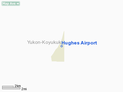
| Serves |
Hughes, Alaska |
| Elevation AMSL |
299 ft / 91 m |
| Coordinates |
66°02′21″N 154°15′53″W / 66.03917°N 154.26472°W / 66.03917; -154.26472 |
| Runways |
| Direction |
Length |
Surface |
| ft |
m |
| 17/35 |
3,380 |
1,030 |
Gravel |
| Statistics |
| Enplanements (2007) |
1,148 |
| Aircraft operations (2005) |
1,480 |
| Source: Federal Aviation Administration |
Hughes Airport (IATA: HUS, ICAO: PAHU, FAA LID: HUS) is a state-owned public-use airport located one nautical mile (1.85 km) southwest of the central business district of Hughes, a city in the Yukon-Koyukuk Census Area of the U.S. state of Alaska.
As per Federal Aviation Administration records, this airport had 1,148 passenger boardings (enplanements) in calendar year 2007, an increase of 1% from the 1,137 enplanements in 2006. Facilities and aircraft
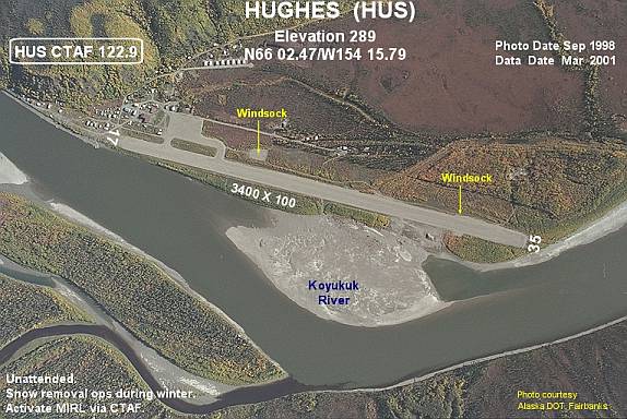
Hughes Airport has one runway (17/25) with a gravel surface measuring 3,380 by 100 feet (1,030 x 30 m). For the 12-month period ending December 31, 2005, the airport had 1,480 aircraft operations, an average of 123 per month: 74% air taxi, 25% general aviation and 1% military.
Airlines and destinations
- Arctic Circle Air (Fairbanks)
- Warbelow's Air Ventures
- Wright Air Service (Fairbanks, Tanana)
The above content comes from Wikipedia and is published under free licenses – click here to read more.
Location & QuickFacts
|
FAA
Information Effective: |
2006-02-16 |
|
Airport Identifier: |
HUS |
|
Longitude/Latitude: |
154-15-47.4850W/66-02-28.0380N
-154.263190/66.041122 (Estimated) |
|
Elevation: |
289
ft / 88.09 m (Surveyed) |
|
Land: |
0
acres |
|
From nearest
city: |
1
nautical miles SW of Hughes, AK |
|
Location: |
Yukon-koyukuk
County, AK |
|
Magnetic
Variation: |
24E
(1985) |
Owner & Manager
|
Ownership: |
Publicly
owned |
|
Owner: |
State
Of Ak Dotpf N Rgn |
|
Address: |
2301
Peger Rd
Fairbanks, AK 99709 |
|
Phone number: |
907-451-2294 |
|
Manager: |
Bill
O'halloran |
|
Address: |
2301
Peger Rd
Fairbanks, AK 99709 |
|
Phone number: |
907-451-5250 |
Airport Operations
and Facilities
|
Airport
Use: |
Open to
public |
|
Wind indicator: |
Yes |
|
Segmented
Circle: |
Yes |
|
Control Tower: |
No |
|
Attendance
Schedule: |
UNATNDD |
|
Lighting
Schedule: |
DUSK-DAWN
ACTVT MIRL RY 17/35 - CTAF. |
|
Beacon Color: |
Clear-Green
(lighted land airport) |
|
Landing fee
charge: |
No |
|
Sectional
chart: |
Fairbanks |
|
Region: |
AAL
- Alaska |
|
Boundary
ARTCC: |
ZAN
- Anchorage |
|
Tie-in FSS: |
FAI
- Fairbanks |
|
FSS on Airport: |
No |
|
FSS Phone: |
907-474-0788 |
|
FSS Toll
Free: |
1-866-248-6516 |
|
NOTAMs Facility: |
FAI
(NOTAM-d service avaliable) |
|
Federal Agreements: |
NS1 |
Airport Communications
Airport Services
|
Airframe
Repair: |
NONE |
|
Power
Plant Repair: |
NONE |
|
Bottled Oxygen: |
NONE |
|
Bulk Oxygen: |
NONE |
|
Runway Information
Runway 17/35
|
Dimension: |
3400 x 100 ft /
1036.3 x 30.5 m |
|
Surface: |
GRAVEL, Good Condition |
|
Edge Lights: |
Medium |
|
|
Runway 17 |
Runway 35 |
|
Longitude: |
154-15-43.1550W |
154-16-02.8930W |
|
Latitude: |
66-02-36.9970N |
66-02-04.5120N |
|
Elevation: |
297.00 ft |
295.00 ft |
|
Alignment: |
127 |
13 |
|
Traffic Pattern: |
Left |
Left |
|
Obstruction: |
22 ft pole, 1000.0 ft from runway, 100 ft left
of centerline, 45:1 slope to clear |
60 ft trees, 1700.0 ft from runway, 28:1 slope
to clear |
|
Radio Navigation Aids
|
ID |
Type |
Name |
Ch |
Freq |
Var |
Dist |
|
UTO |
NDB |
Utopia Creek |
|
272.00 |
25E |
13.6
nm |
Remarks
- RY
CONDITION NOT MONITORED; RECOMMEND VISUAL INSPECTION PRIOR TO LANDING.
- SNOW
REMOVAL OPERATIONS DURING WINTER--MONITOR CTAF.
Operational Statistics
|
Aircraft
Operations: |
29/Week |
|
Air Taxi: |
74.0% |
|
General Aviation
Itinerant: |
24.7% |
|
Military: |
1.4% |
Hughes Airport
Address: Yukon-koyukuk
County, AK
Tel:
907-451-2294,
907-451-5250
Images
and information placed above are from
http://www.airport-data.com/airport/HUS/
We
thank them for the data!
| General
Info |
| Country |
United
States |
| State |
ALASKA
|
| FAA ID |
HUS
|
| Latitude |
66-02-28.038N
|
| Longitude |
154-15-47.485W
|
| Elevation |
289 feet
|
| Near City |
HUGHES
|
We don't guarantee the information is fresh and accurate. The data may be wrong or outdated.
For more up-to-date information please refer to other sources.
|
|