|
|
| Homer Airport |
 |
| IATA: HOM – ICAO: PAHO – FAA LID: HOM |
| Summary |
| Airport type |
Public |
| Owner |
State of Alaska DOT&PF - Central Region |
| Serves |
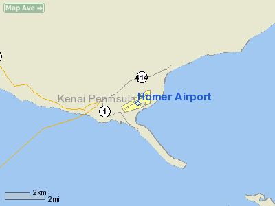
Homer, Alaska |
| Elevation AMSL |
84 ft / 26 m |
| Coordinates |
59°38′44″N 151°28′36″W / 59.64556°N 151.47667°W / 59.64556; -151.47667 (PAHO/HOM Homer airport)Coordinates: 59°38′44″N 151°28′36″W / 59.64556°N 151.47667°W / 59.64556; -151.47667 (PAHO/HOM Homer airport) |
| Runways |
| Direction |
Length |
Surface |
| ft |
m |
| 3/21 |
6,701 |
2,042 |
Asphalt |
| Statistics (2006) |
| Aircraft operations |
49,821 |
| Based aircraft |
93 |
| Source: Federal Aviation Administration |
Homer Airport (IATA: HOM, ICAO: PAHO, FAA LID: HOM) is a state-owned public-use airport located two nautical miles (4 km) east of the central business district of Homer, a town in the Kenai Peninsula Borough of the U.S. state of Alaska. Facilities and aircraft
 | |
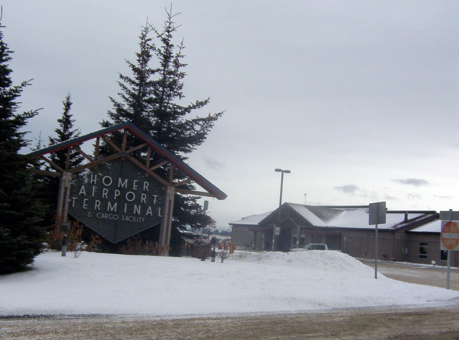
Main terminal on FAA road |
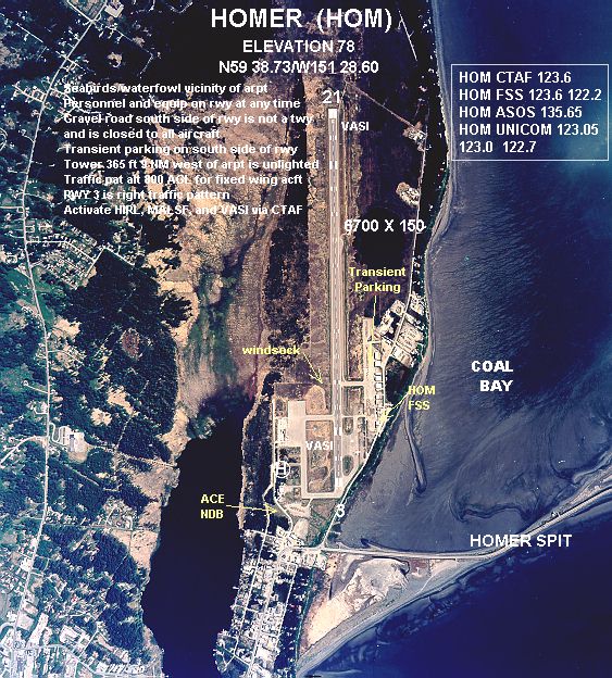
Homer Airport covers an area of 1,040 acres (421 ha) at an elevation of 84 feet (26 m) above mean sea level. It has one runway designated 3/21 with a 6,701 x 150 ft (2,042 x 46 m) asphalt pavement, and a facility for floatplanes on nearby Beluga Lake.
For the 12-month period ending January 1, 2006, the airport had 49,821 aircraft operations, an average of 136 per day: 46% scheduled commercial, 32% air taxi, 22% general aviation and <1% military. At that time there were 93 aircraft based at this airport: 90% single-engine, 4% multi-engine, 3% helicopter and 2% ultralight. The FAA completed a new master plan for the airport in 2006 and expansion and safety improvements are ongoing. The plan calls for a new haul out area for floatplanes, a public-use helipad, a building for managing rescue and firefighting operations based at the airport, and other general improvements.
Airlines and destinations
- Era Aviation (Anchorage)
- Grant Aviation (Anchorage, Kodiak, Valdez)
- Homer Air (Kachemak Bay)
- Smokey Bay Air (Kachemak Bay)
- Island Air Service (Kodiak)
- There are also numerous sightseeing and fly-in fishing and hunting operations.
Notable incidents
In March of 2006, agents from the US Marshal service, in conjunction with local police, attempted to apprehend a violent methamphetamine dealer, Jason Karlo Anderson, who had fled from charges in Minnesota. The suspect had rented a car at the Homer airport, and the rental agent assisted police in luring him back to the airport. Marshals were unaware that the entire Homer High School choir, over 100 students, would be departing for a trip at the same time as the setup. The suspect apparently panicked when he arrived and discovered so many people at the airport, and a shootout ensued in the parking lot. The dealer was killed, but not before severely wounding his own infant son with a gunshot to the head. The infant's mother has contested the finding that Anderson shot his own son and in February 2009 filed against the U.S. Marshals asking for seventy-five million dollars in damages.
The above content comes from Wikipedia and is published under free licenses – click here to read more.
Homer, a small, maritime
community located at the southwest tip of the Kenai Peninsula, receives
much of its economic support from a busy fishing and tourism industry.
Although it enjoys year-round access via the Sterling Highway, Homer
also has an airport that includes a 6,700� x 150� asphalt runway and accommodates
floatplanes on Beluga Lake.
The airport is used as a base of operations
for fishing and sightseeing flights and is also used by other commercial
operators and air cargo carriers. ADOT&PF owns and operates
the airport in Homer and is seeking to update the comprehensive Airport
Master Plan completed in 1985.
Location & QuickFacts
|
FAA
Information Effective: |
2006-02-16 |
|
Airport Identifier: |
HOM |
|
Longitude/Latitude: |
151-28-35.7000W/59-38-44.0000N
-151.476583/59.645556 (Estimated) |
|
Elevation: |
84
ft / 25.60 m (Surveyed) |
|
Land: |
1040
acres |
|
From nearest
city: |
2
nautical miles E of Homer, AK |
|
Location: |
Kenai-cook
Inlet County, AK |
|
Magnetic
Variation: |
24E
(1985) |
Owner & Manager
|
Ownership: |
Publicly
owned |
|
Owner: |
State
Of Ak Dotpf-central Rgn |
|
Address: |
Po
Box 196900
Anchorage, AK 99519-6900 |
|
Phone number: |
907-269-0767 |
|
Manager: |
Mike
Morawitz |
|
Address: |
2336
Kachemak Dr
Homer, AK 99603 |
|
Phone number: |
907-235-8872
ALSO 907-235-4394 OR 907-235-5217 (MESSAGE PHONE). |
Airport Operations
and Facilities
|
Airport
Use: |
Open to
public |
|
Wind indicator: |
Yes |
|
Segmented
Circle: |
Yes |
|
Control Tower: |
No |
|
Attendance
Schedule: |
OCT-MAY/MON-FRI/0300-1900,OCT-MAY/SAT/0600-1300,OCT-MAY/SUN/1100-1900 |
|
Lighting
Schedule: |
DUSK-DAWN
ACTVT HIRL RY 03/21; VASI RYS 03 & 21 & MALSF RY
03 AND MALSR RY 21 - CTAF. |
|
Beacon Color: |
Clear-Green
(lighted land airport) |
|
Landing fee
charge: |
No |
|
Sectional
chart: |
Seward |
|
Region: |
AAL
- Alaska |
|
Traffic Pattern
Alt: |
800
ft |
|
Boundary
ARTCC: |
ZAN
- Anchorage |
|
Tie-in FSS: |
HOM
- Homer |
|
FSS on Airport: |
Yes |
|
FSS Phone: |
907-235-8588 |
|
FSS Toll
Free: |
LC235-8588 |
|
Alternate
FSS: |
ENA
- Kenai |
|
Alt. FSS
Toll Free: |
1-800-WX-BRIEF |
|
NOTAMs Facility: |
HOM
(NOTAM-d service avaliable) |
|
Certification
type/date: |
I
AS 4/1985
PPR FOR ACR OPNS WITH MORE THAN 30 PSGR SEATS WRITE AMGR:
2336 KACHEMAK DR. HOMER; AK 99603. |
|
Federal Agreements: |
NGY |
Airport Communications
|
CTAF: |
123.600 |
|
Unicom: |
123.000
ADDITIONAL UNICOM FREQUENCIES: 122.700, 123.050. |
Airport Services
|
Fuel
available: |
100LLA
B
CALL OUT FEE AFTER 1700 CALL 907-235-7969. |
|
Airframe
Repair: |
MINOR |
|
Power
Plant Repair: |
MINOR |
|
Bottled Oxygen: |
NONE |
|
Bulk Oxygen: |
NONE |
|
Runway Information
Runway 03/21
|
Dimension: |
6701 x 150 ft /
2042.5 x 45.7 m |
|
Surface: |
ASPH,
Poor Condition |
|
Surface Treatment: |
Aggregate Friction Seal Coat |
|
Weight Limit: |
Single wheel: 91000 lbs.
Dual wheel: 118000 lbs.
Dual tandem wheel: 175000 lbs. |
|
Edge Lights: |
High |
|
|
Runway 03 |
Runway 21 |
|
Longitude: |
151-29-29.1478W |
151-27-42.3174W |
|
Latitude: |
59-38-25.0584N |
59-39-02.8951N |
|
Elevation: |
64.00 ft |
68.00 ft |
|
Alignment: |
55 |
127 |
|
ILS Type: |
LOC/DME |
MLS |
|
Traffic Pattern: |
Right |
Left |
|
Markings: |
Precision instrument, Good Condition |
Precision instrument, Good Condition |
|
Crossing Height: |
56.00 ft |
56.00 ft |
|
VASI: |
4-box on left side |
4-box on left side |
|
Visual Glide
Angle: |
3.00� |
3.00� |
|
Approach lights: |
MALSF |
MALSR |
|
Runway End
Identifier: |
No |
No |
|
Obstruction: |
,
50:1 slope to clear |
70 ft tree, 2200.0 ft from runway, 350 ft left
of centerline, 28:1 slope to clear |
|
Radio Navigation Aids
|
ID |
Type |
Name |
Ch |
Freq |
Var |
Dist |
|
ACE |
NDB |
Kachemak |
|
277.00 |
24E |
0.8
nm |
|
HOM |
VOR/DME |
Homer |
093X |
114.60 |
24E |
3.9
nm |
Remarks
- NO
LINE OF SIGHT BETWEEN RY ENDS.
- 365
FT TWR 9 NM W OF ARPT UNLGTD.
- PERSONNEL
AND EQUIPMENT MAY BE WORKING ON THE RY AT ANY TIME.
- TPA
800 FT AGL FOR FIXED WING ACFT; TPA 600 FT AGL & BLO FOR ROTARY
ACFT.
- MAINTENANCE
DUTY HRS 0800-2200.
- REPORTING
SNOW/ICE AND RY CONDITION DURING MAINTENANCE DUTY HRS ONLY.
- TWYS
A, B SOUTH , D & E CLSD TO ACFT OVER 12500 LBS.
- PILOTS
ARE REQUESTED TO SELF-ANNOUNCE ON CTAF PRIOR TO TAXIING ON RWY FOR DEPARTURE;
LEAVING THE RWY AND WITHIN 10 NM OF THE ARPT WHEN APPROACHING TO LAND.
- TRANSIENT
PARKING DESIGNATED WITH GREEN CONES.
- SEA
BIRDS & MIGRATORY WATER FOWL ON & INVOF ARPT DURG SPRING &
SUMMER.
- TRANSIENT
GENERAL AVIATION PARKING ON SOUTH SIDE OF RY.
- LGTD
HELIPAD AT MARITIME HELICOPTERS - BELL SVC CENTER 123.05.
- ARFF
EQUIP STAFFED DURING PERIODS OF ACR OPNS ONLY.
- THE
GRVL ROAD ALONG THE SOUTH SIDE OF RY IS NOT A TWY & IS CLSD TO ALL
ACFT.
Based Aircraft
|
Aircraft
based on field: |
93 |
|
Single Engine Airplanes: |
84 |
|
Multi Engine Airplanes: |
4 |
|
Helicopters: |
3 |
|
Ultralights: |
2 |
Operational Statistics
|
Aircraft
Operations: |
105/Day |
|
Air Carrier: |
3.9% |
|
Air Taxi: |
63.0% |
|
General Aviation
Local: |
15.7% |
|
General Aviation
Itinerant: |
13.1% |
|
Military: |
0.3% |
Homer Airport
Address: Kenai-cook
Inlet County, AK
Tel:
907-269-0767,
907-235-8872
URL:
http://www.homerairport.com/index.html
Images
and information placed above are from
http://www.airport-data.com/airport/HOM/
http://www.homerairport.com/index.html
We
thank them for the data!
| General
Info |
| Country |
United
States |
| State |
ALASKA
|
| FAA ID |
HOM
|
| Latitude |
59-38-44.000N
|
| Longitude |
151-28-35.700W
|
| Elevation |
84 feet
|
| Near City |
HOMER
|
We don't guarantee the information is fresh and accurate. The data may be wrong or outdated.
For more up-to-date information please refer to other sources.
|
|