|
|
| Holy Cross Airport |
 |
| IATA: HCR – ICAO: PAHC – FAA LID: HCA |
| Summary |
| Airport type |
Public |
| Owner |
State of Alaska DOT&PF - Northern Region |
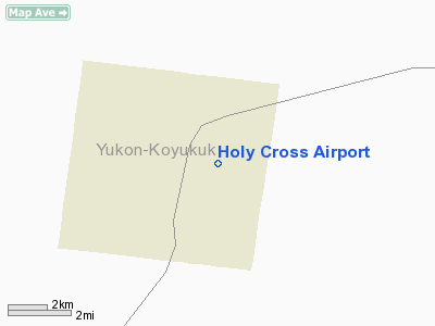
| Location |
Holy Cross, Alaska |
| Elevation AMSL |
70 ft / 21 m |
| Coordinates |
62°11′18″N 159°46′30″W / 62.18833°N 159.775°W / 62.18833; -159.775 |
| Runways |
| Direction |
Length |
Surface |
| ft |
m |
| 1/19 |
4,000 |
1,219 |
Gravel |
| Source: Federal Aviation Administration |
Holy Cross Airport (IATA: HCR, ICAO: PAHC, FAA LID: HCA, formerly 4Z4) is a state-owned public-use airport located one mile (1.6 km) south of the central business district of Holy Cross, a city in the Yukon-Koyukuk Census Area of the U.S. state of Alaska.
Although most U.S. airports use the same three-letter location identifier for the FAA and IATA, Holy Cross Airport is assigned HCA by the FAA and HCR by the IATA. Facilities
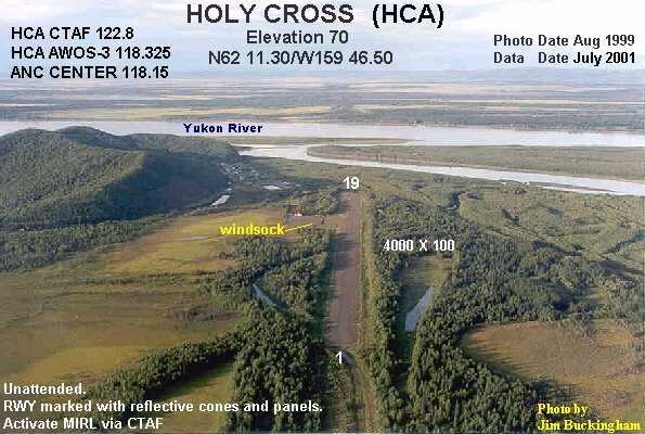
Holy Cross Airport has one runway (1/19) with a gravel and dirt surface measuring 4,000 x 100 ft. (1,219 x 30 m).
Airlines and non-stop destinations
- Frontier Flying Service (Aniak, Anvik)
- Hageland Aviation Services (Aniak, Anvik, Shageluk)
The above content comes from Wikipedia and is published under free licenses – click here to read more.
Location & QuickFacts
|
FAA
Information Effective: |
2006-02-16 |
|
Airport Identifier: |
HCA |
|
Longitude/Latitude: |
159-46-29.7000W/62-11-18.0000N
-159.774917/62.188333 (Estimated) |
|
Elevation: |
70
ft / 21.34 m (Surveyed) |
|
Land: |
0
acres |
|
From nearest
city: |
1
nautical miles S of Holy Cross, AK |
|
Location: |
Kuskokwim
County, AK |
|
Magnetic
Variation: |
18E
(2000) |
Owner & Manager
|
Ownership: |
Publicly
owned |
|
Owner: |
St
Of Ak Dotpf/n Rgn |
|
Address: |
2301
Peger Road
Fairbanks, AK 99709-5399 |
|
Phone number: |
907-451-5250 |
|
Manager: |
George
Beans |
|
Address: |
Box
135
St Mary's, AK 99658 |
|
Phone number: |
907-438-2416 |
Airport Operations
and Facilities
|
Airport
Use: |
Open to
public |
|
Wind indicator: |
Yes
WINDSOCK IN TREES & DOES NOT GIVE ACCURATE WIND INFORMATION. |
|
Segmented
Circle: |
No |
|
Control Tower: |
No |
|
Attendance
Schedule: |
UNATNDD |
|
Lighting
Schedule: |
DUSK-DAWN |
|
Beacon Color: |
Clear-Green
(lighted land airport) |
|
Landing fee
charge: |
No |
|
Sectional
chart: |
Mc
Grath |
|
Region: |
AAL
- Alaska |
|
Boundary
ARTCC: |
ZAN
- Anchorage |
|
Tie-in FSS: |
ENA
- Kenai |
|
FSS on Airport: |
No |
|
FSS Phone: |
800-478-3576 |
|
FSS Toll
Free: |
1-800-WX-BRIEF |
|
NOTAMs Facility: |
ANV
(NOTAM-d service avaliable) |
|
Federal Agreements: |
NGSY |
Airport Communications
Airport Services
|
Airframe
Repair: |
NONE |
|
Power
Plant Repair: |
NONE |
|
Bottled Oxygen: |
NONE |
|
Bulk Oxygen: |
NONE |
|
Runway Information
Runway 01/19
|
Dimension: |
4000 x 100 ft /
1219.2 x 30.5 m |
|
Surface: |
GRVL-DIRT, Fair Condition
SHALLOW PONDING AT TAXIWAY AFTER RAIN. 12 IN HIGH CLUMPS OF GRASS
GROWING ON RUNWAY. |
|
Edge Lights: |
Medium |
|
|
Runway 01 |
Runway 19 |
|
Longitude: |
159-46-51.5780W |
159-46-08.0620W |
|
Latitude: |
62-11-01.0040N |
62-11-34.7260N |
|
Elevation: |
68.00 ft |
70.00 ft |
|
Alignment: |
31 |
127 |
|
Traffic Pattern: |
Left |
Left |
|
Obstruction: |
38 ft trees, 744.0 ft from runway, 192 ft right
of centerline, 19:1 slope to clear |
21 ft trees, 1026.0 ft from runway, 47:1 slope
to clear |
|
Radio Navigation Aids
|
ID |
Type |
Name |
Ch |
Freq |
Var |
Dist |
|
ANI |
NDB |
Aniak |
|
359.00 |
18E |
36.3
nm |
|
ANV |
NDB/DME |
Anvik |
071X |
365.00 |
20E |
29.6
nm |
Remarks
- RY
CONDITION NOT MONITORED; RECOMMEND VISUAL INSPECTION PRIOR TO LANDING.
- MOOSE
ON AND INVOF THE ARPT.
- WX
CAMERA AVBL ON INTERNET AT HTTP://AKWEATHERCAMS.FAA.GOV
Based Aircraft
|
Aircraft
based on field: |
1 |
|
Single Engine Airplanes: |
1 |
Holy Cross Airport
Address: Kuskokwim
County, AK
Tel:
907-451-5250,
907-438-2416
Images
and information placed above are from
http://www.airport-data.com/airport/HCA/
We
thank them for the data!
| General
Info |
| Country |
United
States |
| State |
ALASKA
|
| FAA ID |
HCA
|
| Latitude |
62-11-17.865N
|
| Longitude |
159-46-29.821W
|
| Elevation |
70 feet
|
| Near City |
HOLY CROSS
|
We don't guarantee the information is fresh and accurate. The data may be wrong or outdated.
For more up-to-date information please refer to other sources.
|
|