|
|
| Hollis Seaplane Base |
 |
| IATA: HYL – ICAO: none – FAA LID: HYL |
| Summary |
| Airport type |
Public |
| Owner |
State of Alaska DOT&PF - Southeastern Region |
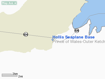
| Serves |
Hollis, Alaska |
| Elevation AMSL |
0 ft / 0 m |
| Coordinates |
55°28′54″N 132°38′46″W / 55.48167°N 132.64611°W / 55.48167; -132.64611 |
| Runways |
| Direction |
Length |
Surface |
| ft |
m |
| NW/SE |
6,000 |
1,829 |
Water |
| E/W |
4,500 |
1,372 |
Water |
| Statistics |
| Aircraft operations (2006) |
450 |
| Enplanements (2008) |
1,661 |
| Source: Federal Aviation Administration |
Hollis Seaplane Base (IATA: HYL, FAA LID: HYL) is a state-owned public-use seaplane base located in Hollis, Prince of Wales-Hyder Census Area in the U.S. state of Alaska.
As per Federal Aviation Administration records, this airport had 1,661 commercial passenger boardings (enplanements) in calendar year 2008, an increase of 30.4% from the 1,274 enplanements in 2007. Hollis Seaplane Base is included in the FAA's National Plan of Integrated Airport Systems (2009-2013), which categorizes it as a general aviation facility.
Facilities and aircraft
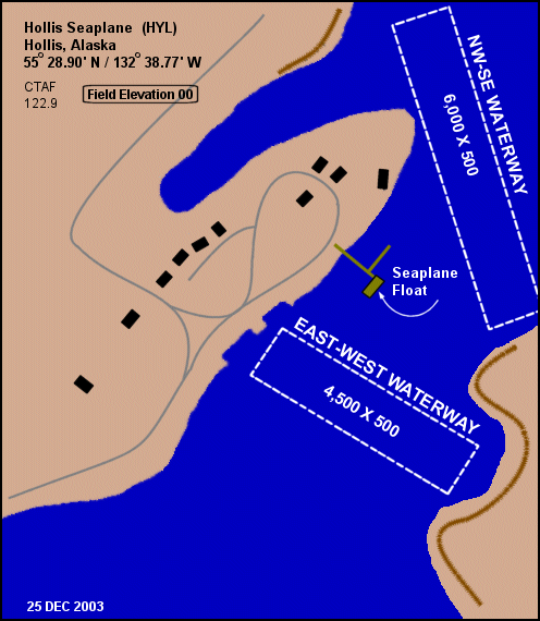
Hollis Seaplane Base has two seaplane landing areas. The NW/SE waterway measures 6,000 by 500 feet (1,829 x 152 m) and the E/W waterway is 4,500 by 500 feet (1,372 x 152 m). For the 12-month period ending December 31, 2006, the airport had 450 aircraft operations, an average of 37 per month: 89% air taxi and 11% general aviation.
Remarks:
- Operating area in Hollis anchorage 1/4 mile southeast of float; boats on float.
- Boats may be tied to seaplane base dock/float ramp.
The above content comes from Wikipedia and is published under free licenses – click here to read more.
Location & QuickFacts
|
FAA
Information Effective: |
2006-02-16 |
|
Airport Identifier: |
HYL |
|
Longitude/Latitude: |
132-38-45.9390W/55-28-53.7180N
-132.646094/55.481588 (Estimated) |
|
Elevation: |
0
ft / 0.00 m (Estimated) |
|
Land: |
0
acres |
|
From nearest
city: |
0
nautical miles W of Hollis, AK |
|
Location: |
Prince
Of Wales County, AK |
|
Magnetic
Variation: |
26E
(1985) |
Owner & Manager
|
Ownership: |
Publicly
owned |
|
Owner: |
State
Of Ak Dotpf-se-reg |
|
Address: |
6860
Glacier Hwy
Juneau, AK 99801-7999 |
|
Phone number: |
904-465-1785 |
|
Manager: |
Duane
James |
|
Address: |
P
O Box 91
Craig, AK 99221-0091 |
|
Phone number: |
907-789-0841 |
Airport Operations
and Facilities
|
Airport
Use: |
Open to
public |
|
Wind indicator: |
No |
|
Segmented
Circle: |
No |
|
Control Tower: |
No |
|
Attendance
Schedule: |
UNATNDD |
|
Landing fee
charge: |
No |
|
Sectional
chart: |
Ketchikan |
|
Region: |
AAL
- Alaska |
|
Boundary
ARTCC: |
ZAN
- Anchorage |
|
Tie-in FSS: |
KTN
- Ketchikan |
|
FSS on Airport: |
No |
|
FSS Phone: |
907-225-9481 |
|
FSS Toll
Free: |
LC225-9481 |
|
NOTAMs Facility: |
KTN
(NOTAM-d service avaliable) |
|
Federal Agreements: |
N |
Airport Communications
Airport Services
|
Airframe
Repair: |
NONE |
|
Power
Plant Repair: |
NONE |
|
Bottled Oxygen: |
NONE |
|
Bulk Oxygen: |
NONE |
|
Runway Information
Runway E/W
|
Dimension: |
4500 x 500 ft /
1371.6 x 152.4 m |
|
Surface: |
WATER,
|
|
|
Runway E |
Runway W |
|
Traffic Pattern: |
Left |
Left |
|
Markings: |
None, |
None, |
|
Runway End
Identifier: |
No |
No |
|
Centerline
Lights: |
No |
No |
|
Touchdown Lights: |
No |
No |
|
Runway NW/SE
|
Dimension: |
6000 x 500 ft /
1828.8 x 152.4 m |
|
Surface: |
WATER,
|
|
|
Runway NW |
Runway SE |
|
Traffic Pattern: |
Left |
Left |
|
Markings: |
None, |
None, |
|
Runway End
Identifier: |
No |
No |
|
Centerline
Lights: |
No |
No |
|
Touchdown Lights: |
No |
No |
|
Radio Navigation Aids
|
ID |
Type |
Name |
Ch |
Freq |
Var |
Dist |
|
CMJ |
NDB |
Clam
Cove |
|
396.00 |
27E |
33.4
nm |
|
ICK |
NDB |
Nichols |
|
266.00 |
27E |
43.4
nm |
|
AKW |
NDB/DME |
Klawock |
105X |
229.00 |
24E |
15.6
nm |
|
ANN |
VORTAC |
Annette Island |
118X |
117.10 |
27E |
44.5
nm |
|
ECH |
VOT |
Ketchikan |
|
111.00 |
|
33.2
nm |
Remarks
- OPRG
AREA IN HOLLIS ANCHORAGE 1/4 MILE SE FLOAT; BOATS ON FLOAT.
- BOATS
MAY BE TIED TO SPB DOCK/FLOAT RAMP
Operational Statistics
|
Aircraft
Operations: |
25/Month |
|
Air Taxi: |
66.7% |
|
General Aviation
Itinerant: |
33.3% |
Hollis Seaplane Base
Address: Prince
Of Wales County, AK
Tel:
904-465-1785,
907-789-0841
Images
and information placed above are from
http://www.airport-data.com/airport/HYL/
We
thank them for the data!
| General
Info |
| Country |
United
States |
| State |
ALASKA
|
| FAA ID |
HYL
|
| Latitude |
55-28-53.718N
|
| Longitude |
132-38-45.939W
|
| Elevation |
0 feet
|
| Near City |
HOLLIS
|
We don't guarantee the information is fresh and accurate. The data may be wrong or outdated.
For more up-to-date information please refer to other sources.
|
|