 |
|
| Haycock Airport |
 |
| IATA: HAY – ICAO: none – FAA LID: HAY |
| Summary |
| Airport type |
Public |
| Owner |
Alaska Department of Natural Resources |
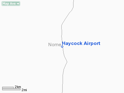
| Serves |
Haycock, Alaska |
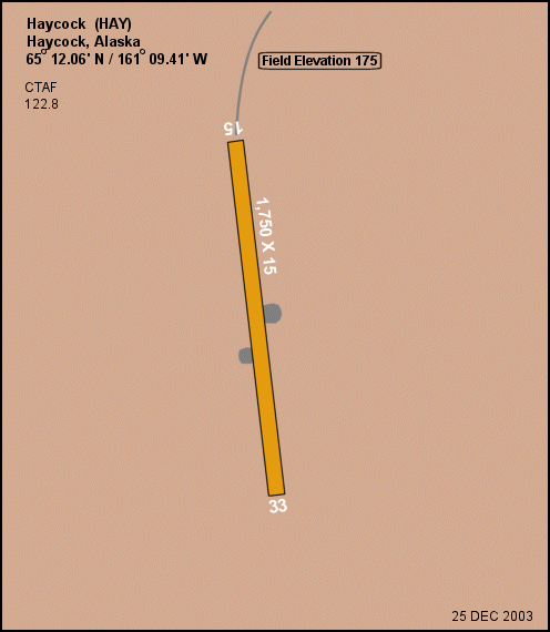
| Elevation AMSL |
175 ft / 53 m |
| Coordinates |
65°12′04″N 161°09′24″W / 65.20111°N 161.15667°W / 65.20111; -161.15667 |
| Runways |
| Direction |
Length |
Surface |
| ft |
m |
| 15/33 |
1,750 |
533 |
Gravel/Dirt |
| Statistics (1992) |
| Aircraft operations |
300 |
| Source: Federal Aviation Administration |
Haycock Airport (IATA: HAY, FAA LID: HAY) was a public-use airport located in Haycock, which is in the Nome Census Area of the U.S. state of Alaska. The airport was publicly owned by the Alaska Department of Natural Resources.
Facilities and aircraft
Haycock Airport had one runway designated 15/33 with a gravel and dirt surface measuring 1,750 by 15 feet (533 x 5 m). For the 12-month period ending July 18, 1992, the airport had 300 aircraft operations, an average of 25 per month: 67% air taxi and 33% general aviation.
The above content comes from Wikipedia and is published under free licenses – click here to read more.
Location & QuickFacts
|
FAA
Information Effective: |
2006-02-16 |
|
Airport Identifier: |
HAY |
|
Longitude/Latitude: |
161-09-24.4050W/65-12-03.5620N
-161.156779/65.200989 (Estimated) |
|
Elevation: |
175
ft / 53.34 m (Estimated) |
|
Land: |
0
acres |
|
From nearest
city: |
0
nautical miles SE of Haycock, AK |
|
Location: |
Nome
County, AK |
|
Magnetic
Variation: |
20E
(1985) |
Owner & Manager
|
Ownership: |
Publicly
owned |
|
Owner: |
Public
Domain |
|
Address: |
|
|
Address: |
|
Airport Operations
and Facilities
|
Airport
Use: |
Open to
public |
|
Segmented
Circle: |
No |
|
Control Tower: |
No |
|
Attendance
Schedule: |
UNATNDD |
|
Landing fee
charge: |
No |
|
Sectional
chart: |
Nome |
|
Region: |
AAL
- Alaska |
|
Boundary
ARTCC: |
ZAN
- Anchorage |
|
Tie-in FSS: |
OME
- Nome |
|
FSS on Airport: |
No |
|
FSS Phone: |
LC
443-2291 |
|
FSS Toll
Free: |
1-800-478-8400 |
|
Alternate
FSS: |
FAI
- Fairbanks |
|
Alt. FSS
Toll Free: |
1-866-248-6516 |
|
NOTAMs Facility: |
OME
(NOTAM-d service avaliable) |
|
Federal Agreements: |
N |
Airport Communications
Airport Services
|
Airframe
Repair: |
NONE |
|
Power
Plant Repair: |
NONE |
|
Bottled Oxygen: |
NONE |
|
Bulk Oxygen: |
NONE |
|
Runway Information
Runway 15/33
|
Dimension: |
1750 x 15 ft / 533.4
x 4.6 m |
|
Surface: |
GRVL-DIRT, Poor Condition
ROLLING; ENTIRE LENGTH ROUGH; DIPS & HUMPS. GRASS OVERGROWTH
4 - 6 INCHES. |
|
|
Runway 15 |
Runway 33 |
|
Traffic Pattern: |
Left |
Left |
|
Obstruction: |
,
50:1 slope to clear |
8
ft brush, 80.0 ft from runway, 63 ft right of centerline,
10:1 slope to clear |
|
Radio Navigation Aids
|
ID |
Type |
Name |
Ch |
Freq |
Var |
Dist |
|
OAY |
NDB |
Norton Bay |
|
263.00 |
19E |
38.1
nm |
|
KKA |
NDB/DME |
Koyuk |
083X |
299.00 |
16E |
16.2
nm |
|
BVK |
NDB/DME |
Buckland |
078X |
325.00 |
19E |
46.8
nm |
|
MOS |
VOR/DME |
Moses
Point |
110X |
116.30 |
19E |
38.2
nm |
Remarks
- RY
15 HILL 15000 FT FM THR.
- RWY
15/33 NOT MAINTANINED.
- RY
15 HAS 15 INCH HUMP AT N END. NO LINE OF SIGHT BETWEEN RY ENDS.
- RY
15/33 SOFT DITCHES & POND LINE E EDGE.
- ESTABD
PRIOR TO 1959.
Operational Statistics
|
Aircraft
Operations: |
25/Month |
|
Air Taxi: |
66.7% |
|
General Aviation
Itinerant: |
33.3% |
Haycock Airport
Address: Nome
County, AK
Tel:
Images
and information placed above are from
http://www.airport-data.com/airport/HAY/
We
thank them for the data!
| General
Info |
| Country |
United
States |
| State |
ALASKA
|
| FAA ID |
HAY
|
| Latitude |
65-12-03.562N
|
| Longitude |
161-09-24.405W
|
| Elevation |
175 feet
|
| Near City |
HAYCOCK
|
We don't guarantee the information is fresh and accurate. The data may be wrong or outdated.
For more up-to-date information please refer to other sources.
|
|


