|
|
| Haines Airport |
 |
| IATA: HNS – ICAO: PAHN – FAA LID: HNS |
| Summary |
| Airport type |
Public |
| Owner |
State of Alaska DOT&PF - Southeastern Region |
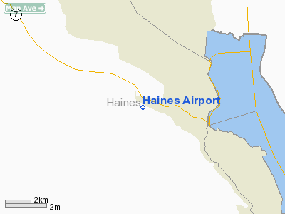
| Location |
Haines, Alaska |
| Elevation AMSL |
15 ft / 5 m |
| Coordinates |
59°14′38″N 135°31′25″W / 59.24389°N 135.52361°W / 59.24389; -135.52361 |
| Runways |
| Direction |
Length |
Surface |
| ft |
m |
| 8/26 |
4,000 |
1,219 |
Asphalt |
| Statistics (2003) |
| Aircraft operations |
7,000 |
| Based aircraft |
34 |
| Source: Federal Aviation Administration |
Diagram of Haines Airport (HNS) Haines Airport (IATA: HNS, ICAO: PAHN, FAA LID: HNS) is a public airport located three miles (5 km) west of the central business district of Haines, a city in Haines Borough in the U.S. state of Alaska. The airport is owned by the state. It is the primary airport for the Haines, Klukwan, Haines Borough area and is situated on the Haines Highway, directly adjacent to the Chilkat River. Facilities and aircraft
Haines Airport covers an area of 124 acres (50 ha) which contains one asphalt paved runway (8/26) measuring 4,000 x 100 ft (1,219 x 30 m).
For the 12-month period ending December 31, 2003, the airport had 7,000 aircraft operations, an average of 19 per day: 86% general aviation and 14% air taxi. There are 34 aircraft based at this airport: 97% single engine and 3% multi-engine.
Airlines and destinations
- Wings of Alaska (Juneau, Skagway)
The above content comes from Wikipedia and is published under free licenses – click here to read more.
Location & QuickFacts
|
FAA
Information Effective: |
2006-02-16 |
|
Airport Identifier: |
HNS |
|
Longitude/Latitude: |
135-31-24.7350W/59-14-37.7850N
-135.523538/59.243829 (Estimated) |
|
Elevation: |
15
ft / 4.57 m (Surveyed) |
|
Land: |
124
acres |
|
From nearest
city: |
3
nautical miles W of Haines, AK |
|
Location: |
Haines
County, AK |
|
Magnetic
Variation: |
24E
(2005) |
Owner & Manager
|
Ownership: |
Publicly
owned |
|
Owner: |
St
Of Ak Dotpf Se Reg |
|
Address: |
6860
Glacier Hwy
Juneau, AK 99801-7999 |
|
Phone number: |
907-465-1785 |
|
Manager: |
Pete
Lapham |
|
Address: |
Box
302
Haines, AK 99827 |
|
Phone number: |
907-766-2340 |
Airport Operations
and Facilities
|
Airport
Use: |
Open to
public |
|
Wind indicator: |
Yes |
|
Segmented
Circle: |
Yes |
|
Control Tower: |
No |
|
Attendance
Schedule: |
UNATNDD |
|
Lighting
Schedule: |
DUSK-DAWN
ACTVT MIRL & PAPI RY 08 & 26 - CTAF. |
|
Beacon Color: |
Clear-Green
(lighted land airport) |
|
Landing fee
charge: |
No |
|
Sectional
chart: |
Juneau |
|
Region: |
AAL
- Alaska |
|
Boundary
ARTCC: |
ZAN
- Anchorage |
|
Tie-in FSS: |
JNU
- Juneau |
|
FSS on Airport: |
No |
|
FSS Phone: |
907-586-7380 |
|
FSS Toll
Free: |
1-800-WX-BRIEF |
|
NOTAMs Facility: |
HNS
(NOTAM-d service avaliable) |
|
Federal Agreements: |
NGSY |
Airport Communications
Airport Services
|
Fuel
available: |
100
NO MILITARY CONTRACT FUEL. |
|
Airframe
Repair: |
MINOR |
|
Power
Plant Repair: |
MINOR |
|
Bottled Oxygen: |
NONE |
|
Bulk Oxygen: |
NONE |
|
Runway Information
Runway 08/26
|
Dimension: |
4000 x 100 ft /
1219.2 x 30.5 m |
|
Surface: |
ASPH,
Good Condition |
|
Edge Lights: |
Medium |
|
|
Runway 08 |
Runway 26 |
|
Longitude: |
135-32-00.8390W |
135-30-48.6320W |
|
Latitude: |
59-14-44.5730N |
59-14-30.9980N |
|
Elevation: |
15.00 ft |
12.00 ft |
|
Alignment: |
110 |
127 |
|
Traffic Pattern: |
Right |
Left |
|
Markings: |
Non-precision instrument, Good Condition |
Non-precision instrument, Good Condition |
|
Crossing Height: |
0.00 ft |
40.00 ft |
|
VASI: |
4-light PAPI on left side
RY 08 PAPI OTS INDEFLY. |
4-light PAPI on left side
RY 26 PAPI OTS INDEFLY. |
|
Visual Glide
Angle: |
0.00� |
2.90� |
|
Runway End
Identifier: |
Yes |
Yes |
|
Obstruction: |
,
50:1 slope to clear |
50 ft trees, 1690.0 ft from runway, 420 ft
left of centerline, 29:1 slope to clear |
|
Radio Navigation Aids
|
ID |
Type |
Name |
Ch |
Freq |
Var |
Dist |
|
HNS |
NDB |
Haines |
|
245.00 |
30E |
3.4
nm |
|
GAV |
NDB |
Gustavus |
|
219.00 |
25E |
49.7
nm |
Remarks
- PILOTS
ARE REQUESTED TO SELF-ANNOUNCE ON CTAF PRIOR TO TAXIING ON RWY FOR DEPARTURE;
LEAVING THE RWY AND WITHIN 10 NM OF THE ARPT WHEN APPROACHING TO LAND.
- NO
WINTER MAINTENANCE TWYS 'D', 'E' & HELIPAD & E 2000 FT TWY 'A'.
W 300 FT RAMP CLSD TO TRANSIENT PARKING FM 15 OCT-30 APR ANNUALLY.
- RECOMMEND
DAYLIGHT OPNS ONLY.
- 50
FT TREES 1000 FT SE RY 26.
- BE
ALERT: SEE GENERAL NOTICES - ENROUTE CTAF FREQS.
- HAINES
AND LENA POINT WX CAMERA AVBL ON INTERNET AT HTTP://AKWEATHERCAMS.FAA.GOV
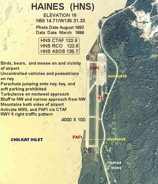
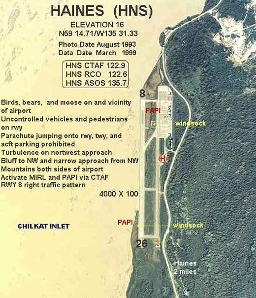
- NARROW
APCH FM NW, MTNS BOTH SIDES; TURBC ON NW APCH, BLUFF NW.
- BIRDS
ON AND IN VICINITY OF AIRPORT.
- SAFETY
AREA 4600 FT X 150 FT (300 FT SAFETY AREA EACH END).
- UNCONTROLLED
VEHICULAR TRAFFIC, PEDESTRIANS, BEARS & MOOSE ON & INVOF RY
& TWY.
- ARPT
CONDITION NOT MONITORED, ARPT MAINT ON IREG BASIS, RECOMMEND VISUAL
INSPECTION PRIOR TO USING.
- PARACHUTE
JUMPING ONTO ARPT RY; TWY & ACFT PARKING APRON PROHIBITED.
- CLSD
TO ACR OPNS WITH MORE THAN 30 PSGR SEATS.
Based Aircraft
|
Aircraft
based on field: |
34 |
|
Single Engine Airplanes: |
33 |
|
Multi Engine Airplanes: |
1 |
Operational Statistics
|
Aircraft
Operations: |
135/Week |
|
Air Taxi: |
14.3% |
|
General Aviation
Local: |
28.6% |
|
General Aviation
Itinerant: |
57.1% |
Haines Airport
Address: Haines
County, AK
Tel:
907-465-1785,
907-766-2340
Images
and information placed above are from
http://www.airport-data.com/airport/HNS/
We
thank them for the data!
| General
Info |
| Country |
United
States |
| State |
ALASKA
|
| ICAO ID |
PAHN
|
| FAA ID |
HNS
|
| Latitude |
59.243831
59� 14' 37.79" N |
| Longitude |
-135.523539
135� 31' 24.74" W |
| Elevation |
15 feet
5 meters |
| Magnetic
Variation |
023� E
(01/06) |
| Beacon |
Yes
|
| Operating
Agency |
U.S.CIVIL
AIRPORT WHEREIN PERMIT COVERS USE BY TRANSIT MILITARY AIRCRAFT
|
| Daylight
Savings Time |
First
Sunday in April at 0200 to last Sunday in October at 0200 local time
(Exception Arizona and that portion of Indiana in the Eastern Time
Zone) |
We don't guarantee the information is fresh and accurate. The data may be wrong or outdated.
For more up-to-date information please refer to other sources.
|
|