 |
|
| Goodnews Airport |
 |
| IATA: GNU – ICAO: none – FAA LID: GNU |
| Summary |
| Airport type |
Public |
| Owner |
State of Alaska DOT&PF - Central Region |
| Serves |
Goodnews, Alaska |
| Elevation AMSL |
15 ft / 5 m |
| Coordinates |
59°07′03″N 161°34′39″W / 59.1175°N 161.5775°W / 59.1175; -161.5775 |
| Runways |
| Direction |
Length |
Surface |
| ft |
m |
| 5/23 |
2,835 |
864 |
Gravel |
| Statistics |
| Aircraft operations (2006) |
3,200 |
| Enplanements (2008) |
1,532 |
| Source: Federal Aviation Administration |
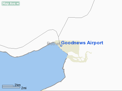
Goodnews Airport (IATA: GNU, FAA LID: GNU) is a state-owned public-use airport located at Goodnews Bay in the Bethel Census Area of the U.S. state of Alaska.
As per Federal Aviation Administration records, this airport had 1,532 commercial passenger boardings (enplanements) in calendar year 2008, a decrease of 2.2% from the 1,567 enplanements in 2007. Goodnews Airport is included in the FAA's National Plan of Integrated Airport Systems (2009-2013), which categorizes it as a general aviation facility.
Facilities and aircraft
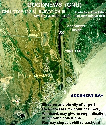
Goodnews Airport has one runway designated 5/23 with a gravel surface measuring 2,835 by 80 feet (864 x 24 m). For the 12-month period ending July 31, 2006, the airport had 3,200 aircraft operations, an average of 266 per month: 62.5% general aviation and 37.5% air taxi. This airport has been surveyed by the National Geodetic Survey.
The above content comes from Wikipedia and is published under free licenses – click here to read more.
Location & QuickFacts
|
FAA
Information Effective: |
2006-02-16 |
|
Airport Identifier: |
GNU |
|
Longitude/Latitude: |
161-34-38.8000W/59-07-02.7000N
-161.577444/59.117417 (Estimated) |
|
Elevation: |
15
ft / 4.57 m (Estimated) |
|
Land: |
0
acres |
|
From nearest
city: |
0
nautical miles SE of Goodnews, AK |
|
Location: |
Bethel
County, AK |
|
Magnetic
Variation: |
18E
(1985) |
Owner & Manager
|
Ownership: |
Publicly
owned |
|
Owner: |
State
Of Ak Dotpf-central Rgn |
|
Address: |
Pouch
196900
Anchorage, AK 99519-6900 |
|
Phone number: |
907-266-1735 |
|
Manager: |
L.
J. Davis |
|
Address: |
Box
505
Bethel, AK 99559 |
|
Phone number: |
907-543-2495 |
Airport Operations
and Facilities
|
Airport
Use: |
Open to
public |
|
Wind indicator: |
Yes
WINDSOCK MAY BE UNRELIABLE. |
|
Segmented
Circle: |
Yes
SEGMENTED CIRCLE OVERGROWN & DAMAGED. |
|
Control Tower: |
No |
|
Attendance
Schedule: |
UNATNDD |
|
Landing fee
charge: |
No |
|
Sectional
chart: |
Kodiak |
|
Region: |
AAL
- Alaska |
|
Boundary
ARTCC: |
ZAN
- Anchorage |
|
Tie-in FSS: |
ENA
- Kenai |
|
FSS on Airport: |
No |
|
FSS Phone: |
800-478-3576 |
|
FSS Toll
Free: |
1-800-WX-BRIEF |
|
NOTAMs Facility: |
PAEH
(NOTAM-d service avaliable) |
|
Federal Agreements: |
NGY |
Airport Communications
Airport Services
|
Airframe
Repair: |
NONE |
|
Power
Plant Repair: |
NONE |
|
Bottled Oxygen: |
NONE |
|
Bulk Oxygen: |
NONE |
|
Runway Information
Runway 05/23
|
Dimension: |
2835 x 80 ft / 864.1
x 24.4 m |
|
Surface: |
GRVL,
Good Condition |
|
|
Runway 05 |
Runway 23 |
|
Longitude: |
161-35-04.1009W |
161-34-13.4358W |
|
Latitude: |
59-06-57.6181N |
59-07-07.6797N |
|
Elevation: |
9.00 ft |
11.00 ft |
|
Alignment: |
69 |
127 |
|
Traffic Pattern: |
Left |
Left |
|
Obstruction: |
15 ft road, 60.0 ft from runway, 4:1 slope
to clear |
,
50:1 slope to clear |
|
Radio Navigation Aids
|
ID |
Type |
Name |
Ch |
Freq |
Var |
Dist |
|
EHM |
NDB |
Cape
Newenham |
|
385.00 |
18E |
31.8
nm |
|
TOG |
NDB/DME |
Togiak |
114X |
393.00 |
19E |
37.3
nm |
Remarks
- CAUTION:
RWY CONDITION NOT MONITORED; RECOMMEND VISUAL INSPECTION PRIOR TO USING.
- RY
05/23 NO SAFETY AREAS.
- BIRDS
ON & INVOF ARPT.
- ROAD
CROSSES MIDPOINT OF RY 05/23.
- PILOTS
ARE REQUESTED TO SELF-ANNOUNCE ON CTAF PRIOR TO TAXIING ON RWY FOR DEPARTURE;
LEAVING THE RWY AND WITHIN 10 NM OF THE ARPT WHEN APPROACHING TO LAND.
Operational Statistics
|
Aircraft
Operations: |
62/Week |
|
Air Taxi: |
37.5% |
|
General Aviation
Itinerant: |
62.5% |
Goodnews Airport
Address: Bethel
County, AK
Tel:
907-266-1735,
907-543-2495
Images
and information placed above are from
http://www.airport-data.com/airport/GNU/
We
thank them for the data!
| General
Info |
| Country |
United
States |
| State |
ALASKA
|
| FAA ID |
GNU
|
| Latitude |
59-07-02.700N
|
| Longitude |
161-34-38.800W
|
| Elevation |
15 feet
|
| Near City |
GOODNEWS
|
We don't guarantee the information is fresh and accurate. The data may be wrong or outdated.
For more up-to-date information please refer to other sources.
|
|


