|
|
Fairbanks International Airport |
| Fairbanks International Airport |
 |
 |
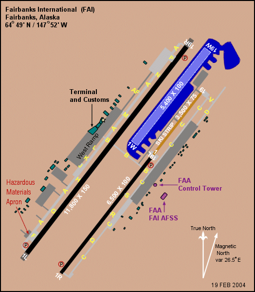
| Fairbanks International Airport diagram. US FAA image. |
| IATA: FAI – ICAO: PAFA – FAA LID: FAI |
| Summary |
| Airport type |
Public |
| Owner |
State of Alaska DOT&PF |
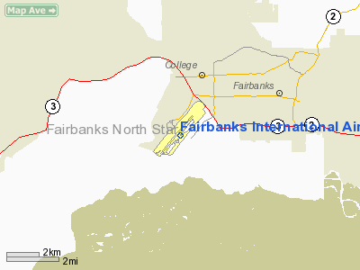
| Location |
Fairbanks, Alaska |
| Elevation AMSL |
434 ft / 132 m |
| Coordinates |
64°48′54″N 147°51′23″W / 64.815°N 147.85639°W / 64.815; -147.85639 |
| Runways |
| Direction |
Length |
Surface |
| ft |
m |
| 2L/20R |
11,800 |
3,597 |
Asphalt |
| 2R/20L |
6,500 |
1,981 |
Asphalt |
| SKI 2/20 |
2,900 |
884 |
Gravel |
| 2W/20W |
5,400 |
1,646 |
Water |
| Statistics (1996/2007) |
| Aircraft operations |
133,267 |
| Based aircraft |
482 |
| Passengers |
898,000 (2007) |
| Source: Federal Aviation Administration |
Fairbanks International Airport (IATA: FAI, ICAO: PAFA, FAA LID: FAI) is a state-owned public-use airport located three miles (5 km) southwest of the central business district of Fairbanks, a city in the Fairbanks North Star Borough of the U.S. state of Alaska.
The airport serves many cargo airlines as a convenient refueling stop for some aircraft on trans-polar routes. FAI is served by a limited number of passenger airlines. Era Aviation and Alaska Airlines serve the airport year-round, while Delta Air Lines and Frontier Airlines serve FAI during the summer. Fairbanks is the smallest city in the United States with non-stop service to Europe, as Condor Airlines offers weekly flights to Frankfurt during the summer tourist season.
Recently, the airport constructed a new terminal and demolished the old one. The new terminal is built around the modern TSA standards. In addition to architectural design and better security, the main terminal now has six jet-bridges (up from the former five).. The new building's footprint is smaller than the old building, and it no longer has the museum exhibits in the lobby. Facilities and aircraft
Fairbanks International Airport covers an area of 3,470 acres (1,404 ha) which contains three runways and one seaplane landing area:
- Runway 2L/20R: 11,800 x 150 ft (3,597 x 46 m), Surface: Asphalt
- Runway 2R/20L: 6,500 x 100 ft (1,981 x 30 m), Surface: Asphalt
- Runway SKI 2/20: 2,900 x 75 ft (884 x 23 m), Surface: Gravel
- Runway 2W/20W: 5,400 x 100 ft (1,646 x 30 m), Surface: Water
For the 12-month period ending August 28, 1996, the airport had 133,267 aircraft operations, an average of 365 per day: 68% general aviation, 18% air taxi, 12% scheduled commercial and 2% military. There are 482 aircraft based at this airport: 89% single engine, 9% multi-engine and 2% helicopters.
AirlinesThe terminal building, situated on the southwest side of the airport, contains seven gates: two for commuter carriers and five for larger carriers. These gates are allocated as follows:
- Gate A: Era Alaska, 40 Mile Air
- Gate B: Era Alaska, 40 Mile Air
- Gate 1: Alaska Airlines
- Gate 2: Alaska Airlines
- Gate 4: Seasonal
- Gate 5: Frontier Airlines
- Gate 6: Seasonal/Int'l
Passenger airlines and destinations
| Airlines |
Destinations |
| Air North |
Dawson City [seasonal] |
| Alaska Airlines |
Anchorage, Barrow, Deadhorse/Prudhoe Bay, Seattle/Tacoma |
| Arctic Circle Air Service |
Anchorage, Allakaket, Anaktuvuk Pass, Arctic Village, Bethel, Bettles, Chalkyitsik, Dillingham, Eagle, Fort Yukon, Galena, Hughes, Huslia, Livengood, Minto, Nulato, Rampart, Tanana, Unalakleet, Venetie |
| Condor |
Frankfurt [seasonal] |
| Delta Air Lines |
Minneapolis/St. Paul, Salt Lake City [all seasonal] |
| Era Alaska (Era Aviation) |
Anchorage, Barrow |
| Everts Air |
Arctic Village, Beaver, Eagle, Fort Yukon, Venetie |
| Frontier Airlines |
Denver [seasonal] |
| Frontier Flying Service |
Anchorage, Barter Island, Fort Yukon, Galena, Kotzebue, Nome, Ruby, Tanana |
| Japan Airlines |
Fukuoka, Nagoya-Centrair, Tokyo-Haneda, Tokyo-Narita [all seasonal charters] |
| Warbelow's Air Ventures |
Bettles, Central, Eagle, Fort Yukon, Galena, Huslia, Rampart, Shungnak, Tanana |
| Wright Air Service |
Allakaket, Anaktuvuk Pass, Arctic Village [seasonal], Bettles, Birch Creek, Coldfoot, Fort Yukon, Tanana |
Cargo airlines
- 40-Mile Air
- Air Cargo Express
- Air Central Express
- Air North
- Alaska Central Express
- Cargolux [fuel stop]
- Everts Air Cargo
- Northern Air Cargo
- Servant Air
- Tanana Air Service
- Tatonduk Flying Service
- Wright Air Service
Charter airlines
- Condor Airlines
- Evert's Air Alaska
- JAL
- Larry's Flying Service
- TEMSCO Helicopters,Arctic Division
- Thomas Cook Airlines
- Warbelow's Air Ventures
The above content comes from Wikipedia and is published under free licenses – click here to read more.
Fairbanks
International Airport (FAI)
Fairbanks International
Airport, known as the Gateway to the Interior, is located close to downtown
Fairbanks, AK. Early aviators in the Alaskan Territory frequently made
do without proper landing strips, putting their airplanes down wherever
there was a flat and clear patch of land. These days, Fairbanks’
modern facilities make flying to the Alaskan interior an easier proposition.
Cargo flights at the airport outnumber passenger flights, but a handful
of passenger airlines and seasonal charter services are available. Alaska
Airlines offers year-round daily direct flights to locations in Alaska
and the Lower 48, and several regional airlines provide service to Anchorage
and interior rural communities like Deadhorse and Prospect Creek. Also,
Thomas Cook Tours charters Condor, Germany's largest leisure-oriented
airline, to provide weekly summer service between Fairbanks and Frankfurt.
Airport history
Early aviators in the Alaskan Territory
frequently made do without prepared landing strips, putting their airplane
down wherever air transportation was required. Aviation service in the
Fairbanks area was initiated at an airfield known as Weeks Field, or Weeks
Ball Park, in 1923. This multi-use facility gained importance in the community
and throughout the Alaska aviation system from the time that Carl Ben
Eielson first flew into Fairbanks in 1923 to start Alaskan Airways. A
majority of the area's general aviation and commercial air traffic was
accommodated here through mid-century, though air carrier aircraft used
Ladd Air Force Base, today referred to as Fort Wainwright. Plans coalesced
in 1948 for development of a new facility - Fairbanks International Airport.
Construction was authorized by Congress that year. Operations were shifted
to the new airport in 1951, though minimal facilities and no terminal
building were then available. Air carriers used temporary structures until
completion of the passenger terminal building in 1954.
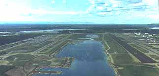
This site, still held today, is located approximately
four miles west from the urban center of Fairbanks, just north of the
confluence of the Chena and Tanana Rivers. Weeks Field is now a residential
area.
The airport was under the charge of the federal government
from its opening until Alaska was granted statehood in 1959. Ownership
and responsibility for operation were then transferred to the State of
Alaska, Department of Public Works, then to the Department of Transportation
and Public Facilities, under whose charge the facility remains today.
 Development
at the airport in past decades has been commensurate with growth in the
community. Two notable traffic increases has occurred. First, a surge
in passenger and enplaned cargo volumes and corresponding aircraft operations
occurred in the years 1974 through 1977, the time when the Trans-Alaska
Pipeline System was under construction. Second, traffic at the airport
changed in character as international air cargo flights began refueling
at Fairbanks in 1979. Japan Airlines and Korean Airlines began service
stops on cargo flights in May of that year. Fairbanks became an attractive
option because of fuel availability. Use of Boeing 747, McDonnell Douglas
DC-10, and McDonnell Douglas DC-8 all-cargo aircraft by these carriers
changed the nature of operations at the airport. These larger, heavier
aircraft place a greater demand on the infrastructure of the airport.
Scheduled international service was discontinued in the spring of 1984,
but regularly scheduled service resumed in September of 1990 with the
introduction of Lufthansa Cargo to the airport. Development
at the airport in past decades has been commensurate with growth in the
community. Two notable traffic increases has occurred. First, a surge
in passenger and enplaned cargo volumes and corresponding aircraft operations
occurred in the years 1974 through 1977, the time when the Trans-Alaska
Pipeline System was under construction. Second, traffic at the airport
changed in character as international air cargo flights began refueling
at Fairbanks in 1979. Japan Airlines and Korean Airlines began service
stops on cargo flights in May of that year. Fairbanks became an attractive
option because of fuel availability. Use of Boeing 747, McDonnell Douglas
DC-10, and McDonnell Douglas DC-8 all-cargo aircraft by these carriers
changed the nature of operations at the airport. These larger, heavier
aircraft place a greater demand on the infrastructure of the airport.
Scheduled international service was discontinued in the spring of 1984,
but regularly scheduled service resumed in September of 1990 with the
introduction of Lufthansa Cargo to the airport.
Notable facility developments have occurred on the air
side and land side in the last three decades. The greatest capacity improvements
came with the construction in 1971 of a general aviation (GA) runway,
1R-19L, parallel to the air carrier runway, and a major passenger terminal
expansion in 1984. More recently, in 1996 and 1997 the main air carrier
runway was lengthened to 11,800 feet to allow wide body freighter aircraft
to takeoff from FAI with unrestricted payloads during virtually all weather
conditions. In 2002 the GA runway was lengthened to 6,500 feet and widened
to 100 feet to accommodate larger aircraft, and the float pond expanded
to add 45 new slips.
Location & QuickFacts
|
FAA
Information Effective: |
2006-02-16 |
|
Airport Identifier: |
FAI |
|
Longitude/Latitude: |
147-51-22.5620W/64-48-54.4110N
-147.856267/64.815114 (Estimated) |
|
Elevation: |
434
ft / 132.28 m (Surveyed) |
|
Land: |
3470
acres |
|
From nearest
city: |
3
nautical miles SW of Fairbanks, AK |
|
Location: |
Fairbanks
County, AK |
|
Magnetic
Variation: |
28E
(1985) |
Owner & Manager
|
Ownership: |
Publicly
owned |
|
Owner: |
State
Of Alaska Dotpf
ALASKA INTL AIRPORT SYSTEM. |
|
Address: |
6450
Airport Way - Suite 1
Fairbanks, AK 99709 |
|
Phone number: |
907-474-2500 |
|
Manager: |
Jesse
Vanderzanden |
|
Address: |
6450
Airport Way - Suite 1
Fairbanks, AK 99709 |
|
Phone number: |
907-474-2500 |
Airport Operations
and Facilities
|
Airport
Use: |
Open to
public |
|
Wind indicator: |
Yes |
|
Segmented
Circle: |
No |
|
Control Tower: |
Yes |
|
Attendance
Schedule: |
ALL/ALL/ALL |
|
Lighting
Schedule: |
DUSK-DAWN |
|
Beacon Color: |
Clear-Green
(lighted land airport) |
|
Landing fee
charge: |
Yes |
|
Sectional
chart: |
Fairbanks |
|
Region: |
AAL
- Alaska |
|
Boundary
ARTCC: |
ZAN
- Anchorage |
|
Tie-in FSS: |
FAI
- Fairbanks |
|
FSS on Airport: |
Yes |
|
FSS Phone: |
907-474-0788 |
|
FSS Toll
Free: |
1-866-248-6516 |
|
NOTAMs Facility: |
FAI
(NOTAM-d service avaliable) |
|
Certification
type/date: |
I
CS 3/1973 |
|
Federal Agreements: |
NGSY |
Airport Communications
|
Unicom: |
122.950
FREQ 122.95 IS MONITORED BY THE FUEL DEALER. |
Airport Services
|
Fuel
available: |
100LLA1 |
|
Airframe
Repair: |
MAJOR |
|
Power
Plant Repair: |
MAJOR |
|
Bottled Oxygen: |
NONE |
|
Bulk Oxygen: |
HIGH/LOW |
|
Runway Information
Runway 01/19
|
Dimension: |
2900 x 75 ft / 883.9
x 22.9 m |
|
Surface: |
GRVL,
|
|
|
Runway 01 |
Runway 19 |
|
Longitude: |
147-50-47.6201W |
147-50-06.3000W |
|
Latitude: |
64-48-57.8024N |
64-49-20.2700N |
|
Elevation: |
428.00 ft |
428.00 ft |
|
Alignment: |
38 |
127 |
|
Traffic Pattern: |
Left |
Left |
|
Runway 01L/19R
|
Dimension: |
11800 x 150 ft /
3596.6 x 45.7 m |
|
Surface: |
ASPH,
Good Condition |
|
Surface Treatment: |
Saw-cut
or plastic Grooved |
|
Weight Limit: |
Single wheel: 75000 lbs.
Dual wheel: 200000 lbs.
Dual tandem wheel: 400000 lbs.
Dual dual tandem wheel: 850000 lbs. |
|
Edge Lights: |
High |
|
|
Runway 01L |
Runway 19R |
|
Longitude: |
147-53-09.2000W |
147-50-21.1700W |
|
Latitude: |
64-48-09.4700N |
64-49-40.9200N |
|
Elevation: |
431.00 ft |
434.00 ft |
|
Alignment: |
38 |
127 |
|
ILS Type: |
ILS/DME |
ILS |
|
Traffic Pattern: |
Left |
Left |
|
Markings: |
Precision instrument, Good Condition |
Precision instrument, Good Condition |
|
Crossing Height: |
50.00 ft |
50.00 ft |
|
Displaced threshold: |
750.00 ft |
750.00 ft |
|
VASI: |
4-light PAPI on left side |
4-light PAPI on left side |
|
Visual Glide
Angle: |
3.00� |
3.00� |
|
RVR Equipment: |
touchdown, midfield, rollout |
touchdown, midfield, rollout |
|
Approach lights: |
ALSF2 |
MALSR |
|
Centerline
Lights: |
Yes |
Yes |
|
Touchdown Lights: |
Yes |
No |
|
Obstruction: |
72 ft tree, 2711.0 ft from runway, 652 ft left
of centerline, 34:1 slope to clear |
86 ft tree, 3096.0 ft from runway, 430 ft right
of centerline, 33:1 slope to clear |
|
Decleard distances: |
Take off run available 11800.00 ft
Take off distance available 12800.00 ft
Actual stop distance available 11800.00 ft
Landing distance available 11050.00 ft |
Take off run available 11800.00 ft
Take off distance available 12800.00 ft
Actual stop distance available 11800.00 ft
Landing distance available 11050.00 ft |
|
Runway 01R/19L
|
Dimension: |
6500 x 100 ft /
1981.2 x 30.5 m |
|
Surface: |
ASPH,
|
|
Edge Lights: |
High |
|
|
Runway 01R |
Runway 19L |
|
Longitude: |
147-52-32.3600W |
147-50-59.8200W |
|
Latitude: |
64-48-00.8000N |
64-48-51.1700N |
|
Elevation: |
428.00 ft |
428.00 ft |
|
Alignment: |
38 |
127 |
|
Traffic Pattern: |
Right |
Left |
|
Crossing Height: |
40.00 ft |
53.00 ft |
|
VASI: |
4-light PAPI on left side |
4-light PAPI on left side |
|
Visual Glide
Angle: |
3.00� |
3.00� |
|
Runway End
Identifier: |
No |
Yes |
|
Runway 01W/19W
|
Dimension: |
5400 x 100 ft /
1645.9 x 30.5 m |
|
Surface: |
WATER,
Good Condition |
|
|
Runway 01W |
Runway 19W |
|
Longitude: |
147-51-16.5600W |
147-49-59.6200W |
|
Latitude: |
64-48-58.0200N |
64-49-39.8600N |
|
Elevation: |
419.00 ft |
419.00 ft |
|
Alignment: |
38 |
127 |
|
Traffic Pattern: |
Left |
Left |
|
Markings: |
Buoys (seaplane base), Good Condition |
Buoys (seaplane base), Good Condition |
|
Obstruction: |
14 ft fence, 553.0 ft from runway, 170 ft left
of centerline, 39:1 slope to clear |
11 ft fence, 505.0 ft from runway, 45:1 slope
to clear |
|
Radio Navigation Aids
|
ID |
Type |
Name |
Ch |
Freq |
Var |
Dist |
|
CUN |
NDB |
Chena |
|
257.00 |
28E |
9.3
nm |
|
FOX |
NDB |
Fox |
|
356.00 |
28E |
11.6
nm |
|
ICW |
NDB |
Ice
Pool |
|
525.00 |
23E |
35.3
nm |
|
EIL |
TACAN |
Eielson |
098X |
|
26E |
21.8
nm |
|
FAI |
VORTAC |
Fairbanks |
023X |
108.60 |
28E |
4.1
nm |
|
ENN |
VORTAC |
Nenana |
105X |
115.80 |
27E |
34.1
nm |
Remarks
- WEST
RAMP CLSD NORTH TWY BRAVO FOR ACFT OVER 55,000 LBS.
- BE
ALERT FOR SNOW REMOVAL EQUIPMENT OPNS FM 1 OCT TO 15 MAY.
- MILITARY
CONTRACT FUEL AVBL.
- BE
ALERT: BLASTING AT 1500 MON-FRI 1 NM RADIUS OF 65 03N 147 37W OF TRUE
NORTH MINE (2 NM NW OF PEDRO DOME) 1500 FT & BLO.
- FOR
AVBLTY OF SKI STRIP RY 01/19 CONSULT LOCAL NOTAMS & CTC ATCT PRIOR
TO ARR/DEP.
- TSNT
PARKING ACFT 18,000 LBS & BLO (NO JET ACFT) EAST RAMP, LMTD TSNT
ACFT PARKING ON W RAMP, ROW 'A' POINTED S, CTC ARPT OPS 907-474-2530
FOR INFORMATION.
- FOR
FLIGHTS IN MOA'S EAST OF FAIRBANKS RECOMMEND CONTACTING EIELSON RANGR
CONTROL ON 125.3 OR CALL 1-800-758-8723 FOR INFORMATION ON MILITARY
ACTIVITES.
- NOISE
ABATEMENT PROCEDURES IN EFECT FM 2200-0800 ALL LARGE ACFT, TURBINE ENGINE,
AND HEAVY ACFT UTILIZE RY 01L FOR ARRS AND 19R FOR DEPS WHEN WIND IS
NOT AN OPERATIOINAL FACTOR.
- COMPASS
ROSE LCTD ON NE ELEPHANT EAR & NW CARGO RAMP.
- BE
ALERT; MAJOR TWY CONST WEST OF RY 01L/19R, APR THRU OCT. CHECK NOTAMS
FOR CURRENT INFORMATION ON TWY ROUTES.
- RY
01R/19L CLSD TO JET ACFT.
- MIGRATORY
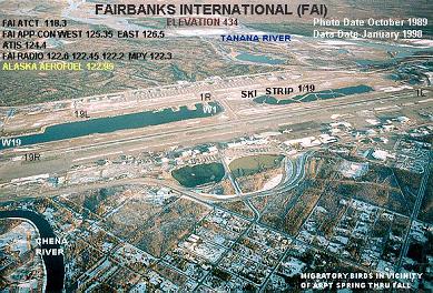
BIRDS INVOF ARPT DURING SPRING THRU FALL.
- N/S
TWY WEST AND PARALLEL RWY 01L/19R, USE CTN TO AVOID LNDG ON TWY.
- ATCT
LOCATED AT 64-48-39.438N 147-50-55.722W ELEVATION 538' MSL.
- SPB
CONTROLLED BY FAIRBANKS INTL ATCT. CTC ATCT ON FREQ 118.3 AS SOON AS
PRACTICAL AFTER START UP FOR TAXI ON THE POND. FLOAT POND TFC AS ASSIGNED
BY FAIRBANKS ATCT. LIMITED TRANSIENT FLOAT PLANE PARKING AVBL, CTC OPNS
907-474-2530 FOR INFORMATION. SFX FROZEN IN WINTER, NOT MONT, AIR OPNS
NOT RCMDD.
- TWY
G UNAVBL TO AIRCRAFT 250000 LBS AND OVER.
Based Aircraft
|
Aircraft
based on field: |
482 |
|
Single Engine Airplanes: |
431 |
|
Multi Engine Airplanes: |
41 |
|
Helicopters: |
10 |
Major Carriers Serving This
Airport
|
Alaska Airlines |
97.1% |
|
Northwest Airlines |
1.5% |
| Delta
Air Lines |
1.5% |
Most Popular Destinations
| Ted
Stevens Anchorage Intl (ANC) |
73.3% |
| Wiley
Post-will Rogers Mem (BRW) |
13.7% |
|
Seattle-tacoma Intl (SEA) |
10.1% |
|
Minneapolis-st Paul Intl/wold-chamberlain/ (MSP) |
1.5% |
| Salt
Lake City Intl (SLC) |
1.5% |
Most Popular Aircraft
|
N747AS |
5.9% |
|
N745AS |
5.3% |
|
N741AS |
5.1% |
|
N746AS |
4.7% |
|
000000 |
3.3% |
|
N730AS |
3.2% |
|
N742AS |
3.1% |
|
N549AS |
2.6% |
|
N546AS |
2.6% |
|
N740AS |
2.5% |
Operational Statistics
|
Aircraft
Operations: |
412/Day |
|
Air Carrier: |
11.2% |
|
Air Taxi: |
15.6% |
|
General Aviation
Local: |
31.2% |
|
General Aviation
Itinerant: |
29.0% |
|
Military: |
1.9% |
Fairbanks International Airport
Address: Fairbanks
County, AK
Tel:
907-474-2500
E-mail:
fai_marketing@dot.state.ak.us
URL:
http://www.dot.state.ak.us/faiiap/index.shtml
Images
and information placed above are from
http://www.airport-data.com/airport/FAI/
http://www.dot.state.ak.us/faiiap/index.shtml
www.tailwinds.org/ alaska/prelim.html
We
thank them for the data!
| General
Info |
| Country |
United
States |
| State |
ALASKA
|
| FAA ID |
FAI
|
| Latitude |
64-48-54.411N
|
| Longitude |
147-51-22.562W
|
| Elevation |
434 feet
|
| Near City |
FAIRBANKS
|
We don't guarantee the information is fresh and accurate. The data may be wrong or outdated.
For more up-to-date information please refer to other sources.
|
|