 |
|
| Elim Airport |
 |
| IATA: ELI – ICAO: PFEL – FAA LID: ELI |
| Summary |
| Airport type |
Public |
| Owner |
State of Alaska DOT&PF - Northern Region |
| Serves |
Elim, Alaska |
| Elevation AMSL |
162 ft / 49 m |
| Coordinates |
64°36′54″N 162°16′14″W / 64.615°N 162.27056°W / 64.615; -162.27056 |
| Runways |
| Direction |
Length |
Surface |
| ft |
m |
| 1/19 |
3,401 |
1,037 |
Gravel |
| Statistics |
| Enplanements (2008) |
2,356 |
| Source: Federal Aviation Administration |
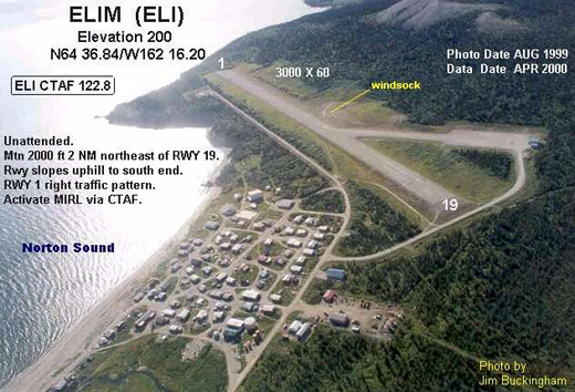
Elim Airport (IATA: ELI, ICAO: PFEL, FAA LID: ELI) is a state-owned, public-use airport located three nautical miles (6 km) southwest of the central business district of Elim, a city in the Nome Census Area of the U.S. state of Alaska.
This airport is included in the FAA's National Plan of Integrated Airport Systems for 2009–2013, where it is listed as commercial service - non-primary, an FAA category for airports with 2,500 to 10,000 passenger boardings (enplanements) per year. However, Federal Aviation Administration records for calendar year 2008 categorized it as general aviation based on 2,356 enplanements that year, a decrease of 26.1% from the 3,189 enplanements in 2007. Facilities
Elim Airport covers an area of 181 acres (73 ha) at an elevation of 162 feet (49 m) above mean sea level. It has one runway designated 1/19 with a gravel surface measuring 3,401 by 60 feet (1,037 x 18 m).
Airlines and non-stop destinations
- Bering Air (Golovin, Koyuk)
- Frontier Flying Service (Golovin, Koyuk)
- Hageland Aviation Services (Golovin, Nome)
The above content comes from Wikipedia and is published under free licenses – click here to read more.
Location & QuickFacts
|
FAA
Information Effective: |
2006-02-16 |
|
Airport Identifier: |
ELI |
|
Longitude/Latitude: |
162-16-17.9000W/64-36-52.9000N
-162.271639/64.614694 (Estimated) |
|
Elevation: |
200
ft / 60.96 m (Estimated) |
|
Land: |
99
acres |
|
From nearest
city: |
3
nautical miles SW of Elim, AK |
|
Location: |
Nome
County, AK |
|
Magnetic
Variation: |
19E
(1985) |
Owner & Manager
|
Ownership: |
Publicly
owned |
|
Owner: |
St
Of Ak - Dot/pf North Reg |
|
Address: |
2301
Peger Rd
Fairbanks, AK 99701 |
|
Phone number: |
907-443-3444 |
|
Manager: |
Harry
Johnson |
|
Address: |
Po
Box 192
Unalakleet, AK 99684 |
|
Phone number: |
907-624-3261 |
Airport Operations
and Facilities
|
Airport
Use: |
Open to
public |
|
Wind indicator: |
Yes |
|
Segmented
Circle: |
Yes |
|
Control Tower: |
No |
|
Attendance
Schedule: |
UNATNDD |
|
Lighting
Schedule: |
DUSK-DAWN
ACTVT MIRL RY 01/19 - CTAF. |
|
Beacon Color: |
Clear-Green
(lighted land airport) |
|
Landing fee
charge: |
No |
|
Sectional
chart: |
Nome |
|
Region: |
AAL
- Alaska |
|
Boundary
ARTCC: |
ZAN
- Anchorage |
|
Tie-in FSS: |
OME
- Nome |
|
FSS on Airport: |
No |
|
FSS Phone: |
LC
443-2291 |
|
FSS Toll
Free: |
1-800-478-8400 |
|
Alternate
FSS: |
FAI
- Fairbanks |
|
Alt. FSS
Toll Free: |
1-866-248-6516 |
|
NOTAMs Facility: |
OME
(NOTAM-d service avaliable) |
|
Federal Agreements: |
NGY |
Airport Communications
Airport Services
|
Airframe
Repair: |
NONE |
|
Power
Plant Repair: |
NONE |
|
Bottled Oxygen: |
NONE |
|
Bulk Oxygen: |
NONE |
|
Runway Information
Runway 01/19
|
Dimension: |
3000 x 60 ft / 914.4
x 18.3 m |
|
Surface: |
GRVL,
Good Condition |
|
Edge Lights: |
Medium |
|
|
Runway 01 |
Runway 19 |
|
Traffic Pattern: |
Right |
Left |
|
Obstruction: |
50 ft hill, 1000.0 ft from runway, 400 ft left
of centerline, 20:1 slope to clear |
,
50:1 slope to clear |
|
Radio Navigation Aids
|
ID |
Type |
Name |
Ch |
Freq |
Var |
Dist |
|
OAY |
NDB |
Norton Bay |
|
263.00 |
19E |
7.3
nm |
|
KKA |
NDB/DME |
Koyuk |
083X |
299.00 |
16E |
34.5
nm |
|
MOS |
VOR/DME |
Moses
Point |
110X |
116.30 |
19E |
7.1
nm |
Remarks
- RY
CONDITION NOT MONITORED; RECOMMEND VISUAL INSPECTION PRIOR TO LANDING.
- +744
FT HILL 8700 FT FM RY END 500 FT R.
- WX
CAMERA AVBL ON INTERNET AT HTTP://AKWEATHERCAMS.FAA.GOV
- ESTABD
PRIOR TO 1959.
Elim Airport
Address: Nome
County, AK
Tel:
907-443-3444,
907-624-3261
Images
and information placed above are from
http://www.airport-data.com/airport/ELI/
We
thank them for the data!
| General
Info |
| Country |
United
States |
| State |
ALASKA
|
| FAA ID |
ELI
|
| Latitude |
64-36-52.900N
|
| Longitude |
162-16-17.900W
|
| Elevation |
200 feet
|
| Near City |
ELIM
|
We don't guarantee the information is fresh and accurate. The data may be wrong or outdated.
For more up-to-date information please refer to other sources.
|
|


