 |
|
Edward G. Pitka Sr Airport |
| Edward G. Pitka Sr. Airport |
 |
| IATA: GAL – ICAO: PAGA – FAA LID: GAL |
| Summary |
| Airport type |
Public |
| Owner |
Alaska DOT&PF - Northern Region |
| Location |
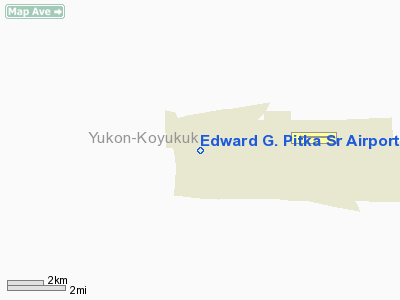
Galena, Alaska |
| Elevation AMSL |
153 ft / 47 m |
| Coordinates |
64°44′10″N 156°56′15″W / 64.73611°N 156.9375°W / 64.73611; -156.9375 |
| Runways |
| Direction |
Length |
Surface |
| ft |
m |
| 7/25 |
7,249 |
2,209 |
Asphalt/Concrete |
| 6/24 |
2,786 |
849 |
Gravel |
| Statistics |
| Based aircraft |
13 |
| Source: Federal Aviation Administration |
Edward G. Pitka Sr. Airport (IATA: GAL, ICAO: PAGA, FAA LID: GAL) is a state-owned public-use airport located in Galena, a city in the Yukon-Koyukuk Census Area of the U.S. state of Alaska. Facilities
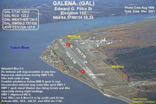
Edward G. Pitka Sr. Airport covers an area of 1,250 acres (506 ha) which contains two runways: 7/25 with an asphalt/concrete pavement measuring 7,249 by 150 feet (2,209 x 46 m) and 6/24 with a gravel surface measuring 2,786 by 80 feet (849 x 24 m).
The airport also sports a ski-jump takeoff ramp at one end and provisions for arresting gear (see picture, ski jump at 07 end) at the other, a leftover from the Cold War years as Galena Air Force Base, as tactical aircraft required more landing and takeoff space than was available on the runway.
Airlines and non-stop destinations
- Arctic Circle Air (Fairbanks)
- Everts Air
- Era Alaska Aviation (Anchorage, Fairbanks, Huslia, Kaltag, Koyukuk, Nulato, Ruby)
- Warbelow's Air Ventures
Military use
Galena Airport was used as a transport base during World War II, facilitating the transit of Lend-Lease aircraft to the Soviet Union.
Galena Air Force Base was also used by the USAF during the Cold War as an interceptor base for aircraft patrolling the western areas of Alaska. It was closed in 1993, however the military airfield is maintained by a private contractor as a weather/emergency diversion airfield since Regular Air Force fighter-interceptor alert operations ended
The above content comes from Wikipedia and is published under free licenses – click here to read more.
Location &
QuickFacts
|
FAA
Information Effective: |
2006-02-16 |
|
Airport
Identifier: |
GAL |
|
Longitude/Latitude: |
156-56-14.6990W/64-44-10.2410N
-156.937416/64.736178 (Estimated) |
|
Elevation: |
152
ft / 46.33 m (Surveyed) |
|
Land: |
1250
acres |
|
From nearest
city: |
0
nautical miles NW of Galena, AK |
|
Location: |
Yukon-koyukuk
County, AK |
|
Magnetic
Variation: |
23E
(1985) |
Owner & Manager
|
Ownership: |
Publicly
owned |
|
Owner: |
St
Of Alask Doptf North Reg |
|
Address: |
2301
Peger Rd
Fairbanks, AK 99701 |
|
Phone number: |
907-451-5217 |
|
Manager: |
Marvin
Thurmond |
|
Address: |
Box
9
Galena, AK 99741 |
|
Phone number: |
907-656-1236 |
Airport Operations
and Facilities
|
Airport
Use: |
Open
to public |
|
Wind indicator: |
Yes |
|
Segmented
Circle: |
Yes |
|
Control
Tower: |
No |
|
Attendance
Schedule: |
ALL/MON-FRI/0800-1700 |
|
Lighting
Schedule: |
DUSK-DAWN
ACTVT HIRL RY 07/25; VASI RYS 07 & 25; REIL RY 07
& SALSF RY 25 - CTAF. SFL'S ARE ONLY ACTVTD WHEN THE
SALSF IS SET TO STEP 5 WHICH IS ACCOMPLISHED BY CLICKING
THE CTAF FREQ 7 KEYS WITHIN 5 SECONDS. |
|
Beacon
Color: |
Clear-Green
(lighted land airport) |
|
Landing
fee charge: |
Yes |
|
Sectional
chart: |
Fairbanks |
|
Region: |
AAL
- Alaska |
|
Boundary
ARTCC: |
ZAN
- Anchorage |
|
Tie-in
FSS: |
FAI
- Fairbanks |
|
FSS on
Airport: |
No |
|
FSS Phone: |
907-474-0788 |
|
FSS Toll
Free: |
1-866-248-6516 |
|
NOTAMs
Facility: |
PAGA
(NOTAM-d service avaliable) |
|
Federal
Agreements: |
NGPY |
Airport Communications
Airport Services
|
Fuel
available: |
100LLA
24 HR CREDIT CARD SYSTEM FOR PURCHASING 100LL & JET
A FUEL. |
|
Bottled
Oxygen: |
NONE |
|
Bulk Oxygen: |
NONE |
|
Runway Information
Runway 06/24
|
Dimension: |
2786 x 80 ft
/ 849.2 x 24.4 m |
|
Surface: |
GRVL,
Good Condition |
|
|
Runway 06 |
Runway 24 |
|
Longitude: |
156-56-51.7180W |
156-55-47.5550W |
|
Latitude: |
64-44-11.7240N |
64-44-11.8720N |
|
Elevation: |
146.00 ft |
148.00 ft |
|
Alignment: |
90 |
127 |
|
Traffic
Pattern: |
Left |
Left |
|
Obstruction: |
,
50:1 slope to clear |
63 ft tower, 900.0 ft from runway, 200
ft left of centerline, 14:1 slope to clear |
|
Runway 07/25
|
Dimension: |
7254 x 150 ft
/ 2211.0 x 45.7 m |
|
Surface: |
ASPH-CONC, Good Condition |
|
Weight Limit: |
Single wheel: 110000 lbs.
Dual wheel: 144000 lbs.
Dual tandem wheel: 240000 lbs. |
|
Edge Lights: |
High |
|
|
Runway 07 |
Runway 25 |
|
Longitude: |
156-57-36.3330W |
156-54-49.2670W |
|
Latitude: |
64-44-09.3360N |
64-44-09.9370N |
|
Elevation: |
147.00 ft |
152.00 ft |
|
Alignment: |
89 |
127 |
|
ILS Type: |
|
LOC/GS
|
|
Traffic
Pattern: |
Left |
Left |
|
Markings: |
Precision instrument, Good Condition
RUNWAY MARKING FAIR TO GOOD |
Precision instrument, Poor Condition |
|
Arresting: |
BAK12 |
BAK12 |
|
Displaced
threshold: |
606.00 ft |
0.00 ft |
|
VASI: |
4-box on left side |
4-box on left side |
|
Approach
lights: |
|
SALSF |
|
Runway
End Identifier: |
Yes |
|
|
Obstruction: |
17 ft berm, 375.0 ft from runway, 10:1
slope to clear
APCH SLOPE 50:1 FROM DSPLCD THR. |
15 ft road, 200.0 ft from runway, 400 ft
left of centerline |
|
Radio Navigation
Aids
|
ID |
Type |
Name |
Ch |
Freq |
Var |
Dist |
|
BZP |
NDB |
Bishop |
|
331.00 |
21E |
3.7
nm |
|
GAL |
VORTAC |
Galena |
095X |
114.80 |
23E |
4.1
nm |
Remarks
- POSSIBLE
WINDSHEAR BELOW 2000 FT AGL ON FINAL APCH TO RWYS 07 & 25.
- BAK-12B
APCH END RY 25 CONNECTED. OTHERS REQUIRE 30 MIN PRIOR NOTICE.
- MIL
ACFT CTC GALENA OPS ON FREQS 372.2 OR 391.2 FOR SVCS. MIL UHF ONLY
MUST REPORT ARRIVAL ON 352.050.
- ARPT
HAZARDOUS REPORTING ONLY PERFORMED DURING DUTY HRS UNLESS PRIOR
ARRANGEMENT IN WRITING WITH ARPT MANAGEMENT PO BOX 09 GALENA AK
99741.
- SNOW
REMOVAL OPERATIONS MONITOR CTAF.
- ACFT
MAY BE CLOSER TO LANDING SURFACE THAN THEY APPEAR TO PILOT.
- ALL
ACFT CARRYING EXPLOSIVE CARGO CTC AMGR 907-656-1236 24 HRS PRIOR
TO ARRIVAL.
- TWY
C CLSD DURG WINTER MONTHS.
- SMALL
ACFT PARKING AREA AND RAMP IN FRONT OF AIR TAXI OPNS IS LIMITED
TO ACFT UP TO 12500 LBS.
- GALENA
WX REPORT AVBL ON 134.5 MON-FRI 1700-0200 EXCP HOLS.
- WINDS
ARE E DUE TO FMQ-13 WIND SENSORS BEING ACCURATE TO WITHIN ONLY +/-
4 KTS. ATC/WX WILL NOT INCLUDE/RELAY WIND CORRECTIONS INTO FORECASTS/PHRASEOLOGY.
AIRCREWS WILL INCORPORATE A +/- 4 KT ACCURACY INTO THEIR DECISION
MAKING PROCESS FOR FLYING OPNS.
- -
- BE
ALERT: AIR DEFENSE ACFT MAY SCRAMBLE AT ANY TIME.
- ULTRALIGHTS
ON AND IN VICINITY OF AIRPORT.
- WX
CAMERA AVBL ON INTERNET AT HTTP://AKWEATHERCAMS.FAA.GOV
- (PAY
PHONE) PAY PHONE AVAILABLE.
- JASU-4/MD-3/-2/MC-1
MODIFIED/-1/MC-2A/.
- NUMEROUS
OBSTRUCTIONS INVOF RY 07/25 NOT IDENTIFIED ON TERMINAL APCH PLATES.
- FLIGHTS
ORIGINATING OUTSIDE OF THE STATE REFER TO ALASKA SECTION OF U.S.
AIR FORCE-FOREIGN CLEARANCE GUIDE.
- ARPT
MAINT DUTY HRS 0800-1600 MON-FRI EXCP HOLS.
- FIRST
USABLE 975' OF RY 25 IS CONCRETE - MAY DIFFER IN APPEARANCE AND
BRAKING ACTION FM REMAINING PORTION OF RY.
Based Aircraft
|
Aircraft
based on field: |
13 |
|
Single Engine
Airplanes: |
10 |
|
Multi Engine
Airplanes: |
1 |
|
Ultralights: |
2 |
Edward
G. Pitka Sr Airport
Address: Yukon-koyukuk
County, AK
Tel:
907-451-5217,
907-656-1236
Images
and information placed above are from
http://www.airport-data.com/airport/GAL/
We
thank them for the data!
| General
Info |
| Country |
United
States |
| State |
ALASKA
|
| FAA
ID |
GAL
|
| Latitude |
64-44-10.241N
|
| Longitude |
156-56-14.699W
|
| Elevation |
152
feet |
| Near
City |
GALENA
|
We don't guarantee the information is fresh and accurate. The data may be wrong or outdated.
For more up-to-date information please refer to other sources.
|
|


