|
|
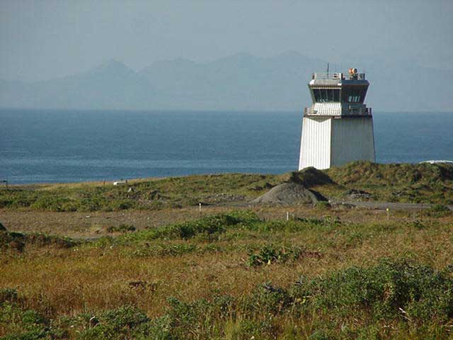
| Eareckson Air Station |
 |
| IATA: SYA – ICAO: PASY |
| Summary |
| Airport type |
Private |
| Operator |
U.S. Air Force |
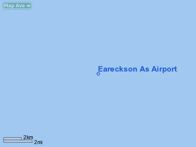
| Location |
Shemya, Alaska |
| Elevation AMSL |
97 ft / 30 m |
| Coordinates |
52°42′44″N 174°06′49″E / 52.71222°N 174.11361°E / 52.71222; 174.11361Coordinates: 52°42′44″N 174°06′49″E / 52.71222°N 174.11361°E / 52.71222; 174.11361 |
| Runways |
| Direction |
Length |
Surface |
| ft |
m |
| 10/28 |
10,000 |
3,048 |
Asphalt/Grooved |
Eareckson Air Station (IATA: SYA, ICAO: PASY) is a U.S. military airbase located on the island of Shemya, in the Alaskan Aleutian Islands. It was Shemya Army Air Base during World War II. Redesignated to Shemya Air Force Base on March 26, 1948, by Department of the Air Force General Order No. 10, it was later renamed Shemya Airport in 1954. It was again redesignated Shemya Air Force Station on January 1, 1959, by Department of the Air Force General Order No. 4 of January 20, 1959. The base was re-redesignated Shemya AFB in 1968. On May 19, 1993, it was renamed Eareckson Air Force Station in honor of Colonel William O. Eareckson, an Army Air Forces combat commander in the Aleutian Islands. The base was redesignated to Eareckson Air Station January 24, 1994. History
During World War II, Eareckson serverd primarily as a bomber base during the Aleutians Campaign Known USAAF units assigned to Shemya were:
- 28th Bombardment Group (February 26, 1944 – October 20, 1945)
- 21st Bombardment Squadron (July 27 – September 19, 1943)
- 404th Bombardment Squadron (February 28, 1944 – January 5, 1947)
- 343d Fighter Group (October 5, 1945 – August 15, 1946)
- 54th Fighter Squadron (October 18 – November 20, 1943)
- 344th Fighter Squadron (June 25, 1943 – August 15, 1946)
Beginnining in 1976, the installation served as the host to many Defense Department "Cobra"-related projects including the Cobra Dane radar and Cobra Ball and other related RC-135 projects. Additionally, in August 1988, at least one Aries rocket was launched, relating to the Queen Match program, for anti-ballistic missile testing.
Facilities
Eareckson Air Station has one runway:
- Runway 10/28: 10,000 by 150 feet (3,000 × 46 m), Surface: Asphalt/Grooved, 28 is ILS equipped.
There is also an NDB, TACAN and a VOR on the island.
Two other runways on the west side of the island were constructed during World War II and have since been abandoned.
Incidents and accidents
- On July 21, 1961, Alaska Airlines Flight 779 crashed at Shemya on a flight from Anchorage after the controller neglected to turn on the runway landing lights. All six onboard were killed in the crash.
- On July 12, 2010, American Airlines Flight 175 diverted to Eareckson on a flight from Dallas-Fort Worth to Narita after a fire alarm went off during flight. No deaths or injuries were reported.
Gallery
The above content comes from Wikipedia and is published under free licenses – click here to read more.
Location &
QuickFacts
|
FAA
Information Effective: |
2006-02-16 |
|
Airport
Identifier: |
SYA |
|
Longitude/Latitude: |
174-06-49.0300E/52-42-44.1900N
-174.113619/52.712275 (Estimated) |
|
Elevation: |
97
ft / 29.57 m (Estimated) |
|
Land: |
0
acres |
|
From nearest
city: |
0
nautical miles S of Shemya, AK |
|
Location: |
Aleutian
Islands County, AK |
|
Magnetic
Variation: |
03E
(1985) |
Owner & Manager
|
Ownership: |
Air Force
owned |
|
Owner: |
U
S Govt Usaf |
|
Address: |
Hqrs
Aac /doos/
Elmendorf Afb, AK 99506 |
|
Manager: |
Commander |
|
Address: |
Shemya Afb, AK |
|
Phone number: |
907-572-3400 |
Airport Operations
and Facilities
|
Airport
Use: |
Private |
|
Wind indicator: |
Yes |
|
Segmented
Circle: |
No |
|
Control
Tower: |
No |
|
Attendance
Schedule: |
ALL/MON-FRI/0900-1700
CLSD WKEND & HOLS |
|
Lighting
Schedule: |
DUSK-DAWN
ACTVT HIRL RY 10/28; VASI RYS 10 & 28; ALSF1 RY 10
& SALSF RY 28 - CTAF. |
|
Beacon
Color: |
Clear-Green
(lighted land airport) |
|
Landing
fee charge: |
No |
|
Sectional
chart: |
W
Aleutian Isls |
|
Region: |
AAL
- Alaska |
|
Boundary
ARTCC: |
ZAN
- Anchorage |
|
Tie-in
FSS: |
CDB
- Cold Bay |
|
FSS on
Airport: |
No |
|
FSS Phone: |
907-532-2454 |
|
FSS Toll
Free: |
1-800-478-7250 |
|
Alternate
FSS: |
ENA
- Kenai |
|
Alt. FSS
Toll Free: |
1-800-WX-BRIEF |
|
NOTAMs
Facility: |
PASY
(NOTAM-d service avaliable) |
Airport Communications
Airport Services
|
Airframe
Repair: |
NONE |
|
Power
Plant Repair: |
NONE |
|
Bottled
Oxygen: |
NONE |
|
Bulk Oxygen: |
NONE |
|
Runway Information
Runway 10/28
|
Dimension: |
9990 x 150 ft
/ 3045.0 x 45.7 m
SURFACE 150 FT WIDE WITH 30 FT SHOULDERS. |
|
Surface: |
ASPH,
|
|
Surface Treatment: |
Saw-cut
or plastic Grooved
RY GROOVED EXCEPT LAST 1500' EACH END. |
|
Weight Limit: |
Single wheel: 100000 lbs.
Dual wheel: 200000 lbs.
Dual tandem wheel: 400000 lbs. |
|
Edge Lights: |
High |
|
|
Runway 10 |
Runway 28 |
|
ILS Type: |
|
LOC/GS
|
|
Traffic
Pattern: |
Left |
Left |
|
Markings: |
Precision instrument, Good Condition |
Precision instrument, Good Condition |
|
Arresting: |
BAK13 |
BAK13 |
|
VASI: |
nonstandard system
RY 10 AND 28. |
nonstandard system |
|
Approach
lights: |
ALSF1 |
SALSF |
|
Runway
End Identifier: |
No |
No |
|
Centerline
Lights: |
No |
No |
|
Touchdown
Lights: |
No |
No |
|
Radio Navigation
Aids
|
ID |
Type |
Name |
Ch |
Freq |
Var |
Dist |
Remarks
- HILLS
8 NM W 662' MSL.
- RWY
10 HAS NON-STD TFC FOR VFR PATTERN.
- RADAR
ANTENNA ON THE NW CORNER OF EARECKSON (52 44N 174 05E).
- RADIATION
HAZARD AREA FROM SFC TO 16000 FT MSL OUT TO 3 NM FOR ACFT WITH EXTERNALLY
MOUNTED ELECTRO EXPLOSIVE DEVICES. (EED) AND POSSIBLE INTERFERENCE
WITH ELECTRONIC EQUIPMENT FOR ACFT OUT TO 3 NM.
- FLEET
SVC NOT AVBL.
- EED
EQUIPPED ACFT MUST ADVISE BASE OPS PRIOR TO DEPARTURE.
- (E60-10)
BAK13(B) LCTD 1800 FT.
- HVY
MIGRATORY GOOSE ACTVT APR-JUN AND AUG-OCT PERIODS MAY POSE A SIGNIFICANT
HAZARD TO ACFT. GULLS & RAVENS IN LOWER NUMBERS ADD TO THE HAZARD
CONDITION THROUGHOUT THE YEAR. RPT ALL BIRD & ANIMAL STRIKES
ON OR INVOF EARECKSON TO AIRFIELD MGMNT DSN 317-392-3505 OR PTD
OR 11 AF/SE 317-552-4730.
- MODE
IV IFF KEY AVBL.
- TRNST
ALERT SVC AVBL 0900-1700; MAINT EXTREMELY LMTD.
- USAF
INSTALLATION, ALL CIVIL ACFT OPERS REQ CIVIL ACFT LNDG PERMITS PRIOR
TO LANDING AT FACILITY. FINES WILL BE LEVIED AGAINST VIOLATORS &
REPORTS WILL BE FWDD TO FAA FSDOS IAW 32CFR855 & USAF OPERG
INSTRGS. OPERS MUST HAVE ON BOARD A COPY OF CURRENT PERMIT. FOR
PERMITS CALL 907-552-7384/3636/5265.
- PPR
FOR ALL FLIGHTS, CTC BASE OPS DSN 317-392-3505, C907-392-3606, ALTERNATE
EARECKSON PROGRAM MGMT OFFICE DSN 317-552-1946/1814.
- TWY
A RESTRICTED TO DAYLIGHT/VFR OPNS ONLY.
- TWY
'D' CLSD INDEFLY.
- ALL
RADIO NAV FAC UNMON 1700-0900 DLY/CONTINUOUS WKND-HOL.
- UNCONTROLLED
ARPT. NO PRAC APCHS. COMSEC MATERIAL UNAVBL.
- SHEER
DROP-OFF EACH END OF RY; NO OVERRUNS.
- POSSIBLE
WIND SHEAR ON BOTH APPROACHES.
- 30
MINUTES PRIOR NOTICE REQUIRED FOR BARRIER SERVICE.
- USE
CARE WHEN LDG DUR LOW VIS & AT NGT; AN ILLUSION OF HEIGHT &
USABLE RY WIDTH COULD OCCUR.
Operational
Statistics
|
Aircraft
Operations: |
24/Week |
|
Military: |
100.0% |
Eareckson
As Airport
Address: Aleutian
Islands County, AK
Tel:
907-572-3400
Images
and information placed above are from
http://www.airport-data.com/airport/SYA/
We
thank them for the data!
| General
Info |
| Country |
United
States |
| State |
ALASKA
|
| FAA
ID |
SYA
|
| Latitude |
52-42-44.190N
|
| Longitude |
174-06-49.030E
|
| Elevation |
97 feet
|
| Near
City |
SHEMYA
|
We don't guarantee the information is fresh and accurate. The data may be wrong or outdated.
For more up-to-date information please refer to other sources.
|
|