|
 |
|
||||
|
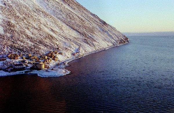
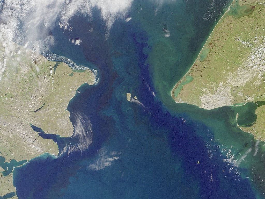
Diomede (native name Inalik, meaning "the other one" or "the one over there") is a city in the Nome Census Area of the Unorganized Borough of the U.S. state of Alaska, located on Little Diomede Island (native name Ignaluk; formerly known as Krusenstern Island which can also refer to other places however). Little Diomede is the smaller of the two Diomede Islands located in the middle of the Bering Strait between the Alaska mainland and Siberia. Its neighboring island Big Diomede, Russia behind the International Date Line is less than 2.4 miles (4 km) away. Diomede lies on the west side of Little Diomede and is the only settlement on the island. The population was 146 at the 2000 census.
Geography
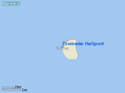
According to the United States Census Bureau, the city has a total area of 2.84 square miles (7.356 km²), all of it land. Little Diomede Island is located about 25 miles (40 km) west from the mainland, in the middle of the Bering Strait. It is only 0.6 miles (1 km) from the International Date Line and about 2.4 miles (4 km) from the Russian island of Big Diomede. The highest point in Little Diomede Island is 919 feet (280 m). GeologyThe Little Diomede island is believed to be a Tuya type mountain and remains from the Bering land bridge (also known as Beringia). The location of the city is the only area which does not have near-vertical cliffs to the water. Behind the city and around the entire island rocky slopes rise at about 40° up to the relatively flattened top in 1,148-1,191 feet (350–363 m). The island has very scant vegetation. HistoryThe current location of the city, which is believed to be at least 3,000 years old by some archaeologists, was originally a spring hunting campsite and the early explorers from the west found the Eskimos at Diomede had an advanced culture including their elaborate whale hunting ceremonies. Trading was made with both continents. 1648-1867The first non-native to reach the Diomede Islands was a Russian explorer Semyon Dezhnev in 1648. But it was a Danish navigator Vitus Bering who re-discovered the islands on August 16, 1728, and named the islands after martyr St. Diomede who was celebrated in Russian Orthodox Church on that date. United States purchased Alaska from Russia in 1867 which included the Little Diomede. The new boundary was drawn between the two Diomede Islands and the Big Diomede was left to Russia. 1880s-1920sAccording to traveler John Muir, on his visit to Diomede Islands in 1880s they found the natives eager to trade away everything they had. The village was perched on the steep rocky slope of the mountain which drops at once sheer into deep water. The huts were mostly built of stone with skin roofs. They looked like mere stoneheaps, black dots on the snow at a distance, with whalebone posts set up and framed at the top to lay their canoes beyond the dogs that would otherwise eat them. During the Nome gold rush at the turn of the 19th century, Diomede villagers traveled to Nome along with the gold seekers, even though Nome was not a native village. People from Diomede arrived in Umiaks and stayed in Nome for the summer, trading and gathering items before they returned to their isolated village. 1940sAccording to Arthur Ahkinga, who lived in the Little Diomede island in turn of the 1940s, the Eskimos on the island made their living by hunting and carving ivory which they traded or sold. Fish they caught were bullheads, tomcods, bluecods and a few others, although the fishing was not so common. During the winter time they used fur parkas and skin mukluks made out of hunted animals to protect themselves from cold and wind. Recreations were skating, snowshoeing, hand ball, football and Eskimo dancing. After dark, people spent the rest of the evening telling jokes and old-time stories. In summer time they travelled with skin boats equipped with outboard motors to either Siberia or Wales, Alaska. The winter travel was limited to the neighboring Big Diomede due to weather conditions. Between July and October half the population went to Nome for selling their carving and skin sewing and trading for supplies. Despite being separated by the new border after the Alaska purchase in 1867, Big Diomede had been home to families now living on Little Diomede and the people living on the American side of the border were very close relatives to those living on the Russian side. The communities on both islands were separated by politics, but connected by family kinships. Despite being officially forbidden, the Eskimos from both islands occasionally visited their neighbors, sometimes under the cover of fog, to meet their relatives and exchange small gifts. The local schoolteachers in Little Diomede counted that 178 people from Big Diomede and the Siberian mainland visited the island only within 6 months between January and July in 1944. At the beginning of the Cold War in the late 1940s the Big Diomede became a Russian military base and all its native residents were removed to mainland Russia. When people from Little Diomede went too close to the Russian side or tried to visit their relatives on the neighboring island during World War II, they were taken captive. According to one of the survivors, Oscar Ahkinga, after 52 days of internment and interrogation, the eskimos were banished and told not to come back. 1950sThe school year 1953-1954 in Little Diomede Island was adapted to better serve the local needs. The teaching took place through the holidays and also some weekends to complete the 180 days of class time before the walrus migration started in the Spring. The annual walrus hunt meant major supply and income possibilities for the villagers, and everybody's help was needed. The primary language at the time was Inupiat, and students were also taught English. The only way of communication with the outside world was by amateur radio. The non-existing health care was somewhat upgraded with a basic medication knowledge by seasonal teachers. 1970sDuring the centuries, the Little Diomede was gradually inhabited as a permanent settlement and the entire island was incorporated into the city in 1970. 1990sAfter the Cold War ended in the early 1990s, an interest of reuniting with families across the Bering Strait revived. In 1994 the people in Little Diomede island collected cash and groceries while local dancers practiced almost every night. The islanders prepared for a visit of more than one hundred friends and relatives from Siberia and they wanted to be hospitable and generous hosts, but many of the residents of Little Diomede never saw their relatives again. DemographicsAs of the census of 2000, there were 146 people, 43 households, and 31 families residing in the city. The population density was 51.4 people per square mile (19.8/km²). There were 47 housing units at an average density of 16.5 per square mile (6.4/km²). The racial makeup of the city was 92.47% Native American, 6.16% White and 1.37% from two or more races. There were 43 households out of which 37.2% had children under the age of 18 living with them, 20.9% were married couples living together, 32.6% had a female householder with no husband present, and 27.9% were non-families. 18.6% of all households were made up of individuals and none had someone living alone who was 65 years of age or older. The average household size was 3.40 and the average family size was 4.00. In the city the population was spread out with 43.8% under the age of 18, 7.5% from 18 to 24, 25.3% from 25 to 44, 17.1% from 45 to 64, and 6.2% who were 65 years of age or older. The median age was 22 years. For every 100 females there were 114.7 males. For every 100 females age 18 and over, there were 121.6 males. The median income for a household in the city was $23,750, and the median income for a family was $24,583. Males had a median income of $41,250 versus $26,875 for females. The per capita income for the city was $29,944. There were 41.4% of families and 35.4% of the population living below the poverty line, including 33.8% of under eighteens and 44.4% of those over 64. CommunityThe location of the city is believed to have been used for at least 3,000 years as a hunting campsite. In the late 1800s, travelers reported people living in huts made out of rocks and with skin roof. (see History). The first square building in the island was a small Catholic church, which was planned by Father Bellarmine Lafortune in 1935 and built by Father Thomas Cunningham during his residency in the island between 1936 and 1947. It was built from donated lumber from Nome. The next square building in the island was a one-room school house, which also served as a home for the teacher's family. A new larger church building built by Father Thomas Carlin and Brother Ignatius Jakes was completed on March 3, 1979. Today there are about 30 buildings on the island, including the residential housing that was mainly built in the 1970s and 1980s. Washeteria has been built to serve the community with a laundromat and showers. A clinic for basic health care has been included within the washeteria. The island also has a school library, heliport and a satellite dish for television, telephone, fax, and Internet service. There is no bank nor restaurant and the only store in the island has its supplies mainly limited to some food, beverage, clothing, firearms, ammunition, and fuel. Snacks, clothing, diapers, and other items are often ordered from Anchorage Walmart and Fred Meyer stores by mail or parcel. As in many other eskimo villages, importation and sale of alcohol is prohibited. ElectricityAn electric system was built to the island in the 1970s and electricity is provided by city-operated Diomede Joint Utilities. They provide houses and other facilities with electricity produced by diesel generators. Diesel fuel is stored in large tanks which are placed at the furthest possible location from the housing. While the electric facility owns the largest fuel tank measuring 80,000 U.S. gallons (300 m³), the school and the village council store both own tanks measuring about 41,000 U.S. gallons (155 m³) each. (Some sources suggests the school has upgraded its fuel storage to two 85,000-U.S. gallon (325 m³) tanks). Gasoline and propane is also used for fuel. Water and disposalWater for winter use is drawn from a mountain spring, then treated and stored in 434,000-U.S. gallon (1650 m³) storage tank. Because the permafrost does not allow pipelines being installed under ground, residents carry water from the tank. Even with a tank this size, the water supply usually runs out by March, washeteria is closed and residents must melt their drinking water from snow and ice. Funds for improving the water system have been requested both by the city and the school. Having a separate tank for the school would decrease the usage of city water and would also serve as a backup water supply for the whole city. Funds are also requested for refuse collection improvements and for an incinerator, because the ground conditions on the island limits waste disposal to burning combustibles and disposing everything else on the ice. Honeybuckets and privies are used except in the washeteria and clinic which are served by a septic system. EducationLikely the most isolated school in United States, the Diomede School has grades from Pre-K through 12 and approximately 40 students and 5 teachers. The island's only school is served by the Bering Strait School District. Health care and emergency servicesThere is no hospital on the island and emergency services are limited due to the remoteness of the island. A City Council owned clinic operates in the Washeteria building, providing basic health care. While other emergency services are provided by volunteers and health aide, the fire and rescue service is provided by Diomede Volunteer Fire Department and First Responders. In such a small community practically anybody will help in case of an emergency. In case of a major health emergency, patients are airlifted to the mainland hospital in Nome, weather permitting. Nome State Trooper, the closest law enforcement officials are in mainland, Alaska. Frozen ground and lack of soil on the rocky island also prevents digging graves, but rocks are piled on top of the burial sites instead. On 7 November 2009 it was announced that one inhabitant was infected with H1N1 swine flu. [1] EconomyEmploymentEmployment on the island is mostly limited to the city, post office and school. There have been a few seasonal jobs, such as mining and construction, but recently these have been in decline. The Diomede people are excellent ivory carvers and the city serves as a wholesale agent for the ivory. Ivory works are mainly sold in mainland Alaska in Fairbanks and Anchorage, but can occasionally be found also at online auction sites. They also hunt whales during the spring from openings in the sea ice. The whaling practices were unsuccessful or were not pursued for decades in the middle to late 20th century until 1999 when it became successful again. TaxesThe city levies a 3% sales tax, but there are no property taxes on the island. TransportationHistoryIn the early 1940s, one of the Little Diomede villagers wrote "No airplane comes to Diomede except for some very special reason, during the winter. The MS North Star brings groceries for the people on the island from Nome. At the same time she unloads freight for the school teachers. The Coast Guard cutter Northland comes in twice during the summer to look after the natives". Internal transportThere are no roads, highways, railroads, or internal waterways on the island. There are ancient but faint rocky trails heading north and south from the City of Diomede. There are also trails between the buildings. In the fall of 2008, many of the footpaths within the city were replaced by a system of boardwalks and stairs. On the small island with total land area of only 2.8 square miles (7.4 km) only ways to get from place to place is by foot, skis, or snowmobile. Because all other parts of the island remain uninhabited, excluding the city, no other internal transport systems have been constructed. External transportDue to the remoteness and severe weather, Little Diomede Island is very difficult and risky to access from the outside world. An average of 12-15 knot (6-8 m/s; ) winds with gusts up to 48-68 knots (25–35 m/s), a prevalent fog and cloudy sky limit transportation to a minimum. Even medical evacuation from such a location has its own difficulties. Mail has been delivered to the island by helicopter since 1982 and is currently delivered weekly. The postal contract is one of the oldest in the nation, the only one that uses helicopters for delivering mail, and with a cost of over $300,000 annually, is the most expensive in Alaska. An annual delivery of goods and supplies is made by barge during the summer, which usually is the only cargo delivered during the year. When the supplies come, all the men rush down and pull them off and carry them up. Other visitors to the island include the occasional visits by research teams, rare extreme tourists and other Alaska Natives visiting from the mainland Alaska. Due to its location and weather conditions, transportation to the island is very expensive. Having very few economic development opportunities and a tight budget, the city charges non-business visitors arriving by plane or boat a $50.00 fee. When US Senator Ted Stevens arrived to the island on October 29, 2002, for an overnight visit, he commented "I did not realize you were this remote". He arrived by a National Guard Blackhawk helicopter and was the first time the island was visited by a statewide elected official. HelicopterMain access to the island is by helicopter. Until the late 1990s, the bow of a shipwrecked old barge served as a temporary landing platform. Today there is a heliport in the village (FAA ID: DM2) constructed by the US Marine Corps in 2000 and owned by the State of Alaska Department of Transportation. The concrete-surfaced heliport measures 64 feet x 64 feet (20 m x 20 m). It is open to the public, has no control tower and is only about 0.6 miles (1 km) from the International Date Line and less than 2.4 miles (4 km) from Big Diomede. It is the closest US heliport to Russia. AirplaneCurrently there are no airports on Little Diomede Island because of the island's rocky, steep slopes. Most winters, a temporary ice runway is cleared on top of the sea ice just off of the coast of the village, however in some years ice conditions prevent construction. Some bush pilots have occasionally landed on the top of the tuya which is rocky, but has a somewhat flat surface during the snowy winter. The only way to land with an airplane during the few summer months is on water with a float plane. All types of landings on the island with an airplane are very rare due to the high risk and severe weather. There are some thoughts and studies if a runway should be built on the island. BoatThere is no port in the Little Diomede Island and surrounding thick Arctic sea ice limits boat access to the island to only a few summer months. High waves and huge blocks of ice in the area make navigation very risky and difficult. Landing by boat is also difficult and dangerous because of the rocky shoreline of Little Diomede Island. The barge delivering supplies once a year and occasional other water crafts usually stay offshore due to conditions of the shoreline. Transportation improvementsThere have been studies of improving the transportation system within and out of the island. Proposals and studies vary between a port, runway and the Intercontinental Tunnel or Bridge. According to the National Association for State Community Services Programs (NASCSP) the difficult and limited access to the island has put economic pressure on the community, and the tribal council has already voted to begin planning for relocation of the community to the mainland if access and housing conditions are not improved. No plan to constructing a port, airport, runway, tunnel or bridge has been put into action. According to 2006 United States Environmental Protection Agency (EPA) documentation, however, better access to the island will raise issues with its dedicated nature, environment and local traditions and also impact the identity of the Inupiat Eskimo community by increasing social contacts with the outsiders. Air and waterThere have been multiple studies of navigation improvements, a feasibility study of constructing an airport or runway on the island, and studies of any multi-use possibilities of the port and the airport projects as a storm damage prevention. Bridge or tunnelThere have been thoughts and proposals about constructing an intercontinental bridge or tunnel between the Alaska mainland and mainland Siberia, which in some proposals is tied to the possibility of closing the 800-mile (1,300-km) gap in railroad between Alaska and British Columbia. An envisioned service access to one or both Diomede Islands from such bridge or tunnel would dramatically improve transportation to the Little Diomede and also make access safer. Though these proposals date back as far as the early 1800s, most of them have been just visions of individuals or groups, and have not resulted in governmental study by either the USA or Russia. The above content comes from Wikipedia and is published under free licenses – click here to read more.
Runway InformationHelipad H1
Radio Navigation Aids
Remarks
Diomede Heliport Address: Aleutian Islands County, AK Tel: 907-451-5250, 907-443-3431 Images
and information placed above are from We thank them for the data!
We don't guarantee the information is fresh and accurate. The data may be wrong or outdated. For more up-to-date information please refer to other sources. |
||||||||||||||||||||||||||||||||||||||||||||||||||||||||||||||||||||||||||||||||||||||||||||||||||||||||||||||||||||||||||||||||||||||||||||||||||||||||||||||||||||||||||||||||||||||||||

 |
|
Copyright 2004-2026 © by Airports-Worldwide.com, Vyshenskoho st. 36, Lviv 79010, Ukraine Legal Disclaimer |