|
|
| Deering Airport |
 |
| IATA: DRG – ICAO: PADE – FAA LID: DEE |
| Summary |
| Airport type |
Public |
| Owner |
State of Alaska DOT&PF - Northern Region |
| Serves |
Deering, Alaska |
| Elevation AMSL |
21 ft / 6 m |
| Coordinates |
66°04′10″N 162°45′59″W / 66.06944°N 162.76639°W / 66.06944; -162.76639 |
| Runways |
| Direction |
Length |
Surface |
| ft |
m |
| 2/20 |
3,300 |
1,006 |
Gravel |
| 11/29 |
2,640 |
805 |
Gravel |
| Source: Federal Aviation Administration |
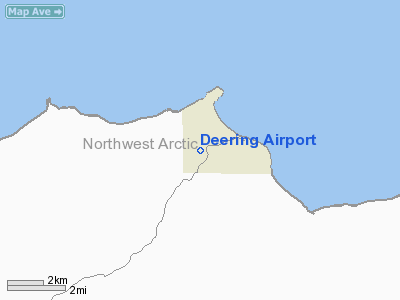
Deering Airport (IATA: DRG, ICAO: PADE, FAA LID: DEE) is a state-owned public-use airport located two nautical miles (3.7 km) southwest of the central business district of Deering, a city in the Northwest Arctic Borough of the U.S. state of Alaska.
Although most U.S. airports use the same three-letter location identifier for the FAA and IATA, this airport is assigned DEE by the FAA and DRG by the IATA. The airport's ICAO identifier is PADE. Facilities
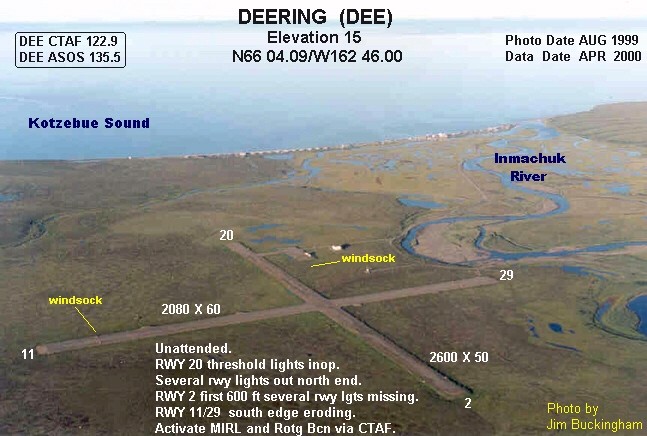
Deering Airport covers an area of 262 acres (106 ha) at an elevation of 21 feet (6 m) above mean sea level. It has two gravel surfaced runways: 2/20 measures 3,300 by 75 feet (1,006 x 23 m) and 11/29 is 2,640 by 75 feet (805 x 23 m).
Airlines and destinations
- Bering Air (Buckland, Kotzebue)
- Frontier Flying Service (Buckland, Kotzebue, Nome)
- Hageland Aviation Services (Kotzebue)
The above content comes from Wikipedia and is published under free licenses – click here to read more.
Location & QuickFacts
|
FAA
Information Effective: |
2006-02-16 |
|
Airport Identifier: |
DEE |
|
Longitude/Latitude: |
162-45-58.9230W/66-04-10.4200N
-162.766367/66.069561 (Estimated) |
|
Elevation: |
21
ft / 6.40 m (Surveyed) |
|
Land: |
262
acres |
|
From nearest city: |
2
nautical miles SW of Deering, AK |
|
Location: |
Kobuk
County, AK |
|
Magnetic Variation: |
19E
(1985) |
Owner & Manager
|
Ownership: |
Publicly owned |
|
Owner: |
St
Of Ak Dotpf N Reg |
|
Address: |
2301
Peger Rd
Fairbanks, AK 99709 |
|
Phone number: |
907-451-5250 |
|
Manager: |
Kenny
Gallahorn |
|
Address: |
Box
55
Kotzebue, AK 99752 |
|
Phone number: |
907-442-3147 |
Airport Operations and Facilities
|
Airport
Use: |
Open to public |
|
Wind indicator: |
Yes |
|
Segmented Circle: |
Yes
SEGMENTED CIRCLE OVERGROWN. |
|
Control Tower: |
No |
|
Attendance Schedule: |
UNATNDD |
|
Lighting Schedule: |
RDO-CTL
ACTVT ROTG BCN - CTAF. |
|
Beacon Color: |
Clear-Green
(lighted land airport) |
|
Landing fee charge: |
No |
|
Sectional chart: |
Nome |
|
Region: |
AAL
- Alaska |
|
Boundary ARTCC: |
ZAN
- Anchorage |
|
Tie-in FSS: |
OTZ
- Kotzebue |
|
FSS on Airport: |
No |
|
FSS Phone: |
907-442-3310 |
|
FSS Toll Free: |
1-478-7460 |
|
Alternate FSS: |
FAI
- Fairbanks |
|
Alt. FSS Toll Free: |
1-866-248-6516 |
|
NOTAMs Facility: |
DEE
(NOTAM-d service avaliable) |
|
Federal Agreements: |
NGY |
Airport Communications
Airport Services
|
Airframe
Repair: |
NONE |
|
Power
Plant Repair: |
NONE |
|
Bottled Oxygen: |
NONE |
|
Bulk Oxygen: |
NONE |
Runway Information
Runway 02/20
|
Dimension: |
3300 x 75 ft / 1005.8
x 22.9 m |
|
Surface: |
GRVL,
Good Condition
GRASS GROWING ON RY EDGES. RY PLOWED IN WINTER.
S EDGE ERODING. |
|
Edge Lights: |
Medium
RY 20 THR LGTS INOP. SEVERAL RY LGTS OUT N END. RY 02 FIRST 600
FT SEVERAL RY LGTS MISSING. |
|
|
Runway 02 |
Runway 20 |
|
Longitude: |
162-46-26.5200W |
162-45-37.3570W |
|
Latitude: |
66-03-54.7900N |
66-04-20.4020N |
|
Elevation: |
14.00 ft |
11.00 ft |
|
Alignment: |
37 |
127 |
|
Traffic Pattern: |
Left |
Left |
|
Runway End
Identifier: |
Yes |
No |
|
Runway 11/29
|
Dimension: |
2640 x 75 ft / 804.7
x 22.9 m |
|
Surface: |
GRVL,
Good Condition
GRASS GROWING ON RY EDGES. RY PLOWED IN WINTER.
S EDGE ERODING. |
|
Edge Lights: |
Medium
RY 20 THR LGTS INOP. SEVERAL RY LGTS OUT N END. RY 02 FIRST 600
FT SEVERAL RY LGTS MISSING. |
|
|
Runway 11 |
Runway 29 |
|
Longitude: |
162-46-26.3800W |
162-45-34.9400W |
|
Latitude: |
66-04-18.0000N |
66-04-02.5600N |
|
Elevation: |
21.00 ft |
12.00 ft |
|
Alignment: |
126 |
127 |
|
Traffic Pattern: |
Left |
Left |
|
Radio Navigation Aids
|
ID |
Type |
Name |
Ch |
Freq |
Var |
Dist |
|
BVK |
NDB/DME |
Buckland |
078X |
325.00 |
19E |
39.9
nm |
|
OTZ |
VOR/DME |
Kotzebue |
104X |
115.70 |
19E |
49.4
nm |
Remarks
- RY
COND NOT MONITORED; RCMD VISUAL INSPECTION PRIOR TO LNDG.
Deering Airport
Address: Kobuk
County, AK
Tel:
907-451-5250,
907-442-3147
Images
and information placed above are from
http://www.airport-data.com/airport/DEE/
We
thank them for the data!
| General
Info |
| Country |
United
States |
| State |
ALASKA
|
| FAA ID |
DEE
|
| Latitude |
66-04-10.420N
|
| Longitude |
162-45-58.923W
|
| Elevation |
20 feet
|
| Near City |
DEERING
|
We don't guarantee the information is fresh and accurate. The data may be wrong or outdated.
For more up-to-date information please refer to other sources.
|
|