 |
|
| Clear Airport |
 |
| IATA: none – ICAO: PACL – FAA LID: Z84 |
| Summary |
| Airport type |
Public / Military |
| Owner |
State of Alaska DOT&PF – Northern Region |
| Serves |
Clear, Alaska |
| Elevation AMSL |
552 ft / 168 m |
| Coordinates |
64°18′04″N 149°07′13″W / 64.30111°N 149.12028°W / 64.30111; -149.12028 |
| Runways |
| Direction |
Length |
Surface |
| ft |
m |
| 1/19 |
4,000 |
1,219 |
Asphalt |
| Statistics (2005) |
| Aircraft operations |
2,000 |
| Based aircraft |
12 |
| Source: Federal Aviation Administration |
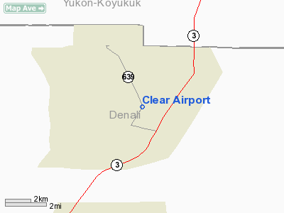
Clear Airport (ICAO: PACL, FAA LID: Z84) is a state-owned public-use airport located three nautical miles (6 km) southeast of the central business district of Clear, Alaska, United States.
Facilities and aircraft
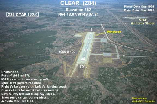
Clear Airport covers an area of 1,127 acres (456 ha) at an elevation of 552 feet (168 m) above mean sea level. It has one runway designated 1/19 with a 4,000 by 100 ft (1,219 x 30 m) asphalt pavement.
For the 12-month period ending December 31, 2005, the airport had 2,000 aircraft operations, an average of 166 per month: 75% general aviation and 25% military. At that time there were 12 aircraft based at this airport, all single-engine.
The above content comes from Wikipedia and is published under free licenses – click here to read more.
Location & QuickFacts
|
FAA
Information Effective: |
2005-10-27 |
|
Airport Identifier: |
Z84 |
|
Longitude/Latitude: |
149-07-12.5170W/64-18-04.3330N
-149.120144/64.301204 (Estimated) |
|
Elevation: |
552
ft / 168.25 m (Estimated) |
|
Land: |
1127
acres |
|
From nearest city: |
3
nautical miles SE of Clear, AK |
|
Location: |
Yukon-koyukuk
County, AK |
|
Magnetic Variation: |
27E
(1985) |
Owner & Manager
|
Ownership: |
Publicly owned |
|
Owner: |
State
Of Ak Dotpf/north Rgn |
|
Address: |
2301
Peger Rd
Fairbanks, AK 99709 |
|
Phone number: |
907-451-2294 |
|
Manager: |
Dean
Owen |
|
Address: |
2301
Peger Rd
Fairbanks, AK 99709-5316 |
|
Phone number: |
907-451-5217 |
Airport Operations and Facilities
|
Airport
Use: |
Open to public |
|
Wind indicator: |
Yes
WINDSOCK INTERNALLY LIT. |
|
Segmented Circle: |
Yes |
|
Control Tower: |
No |
|
Attendance Schedule: |
UNATNDD |
|
Lighting Schedule: |
24
HRS
ACTVT MIRL RY 01/19 - CTAF. |
|
Beacon Color: |
Clear
(unlighted land airport) |
|
Landing fee charge: |
No |
|
Sectional chart: |
Fairbanks |
|
Region: |
AAL
- Alaska |
|
Boundary ARTCC: |
ZAN
- Anchorage |
|
Tie-in FSS: |
FAI
- Fairbanks |
|
FSS on Airport: |
No |
|
FSS Phone: |
907-474-0788 |
|
FSS Toll Free: |
1-866-248-6516 |
|
NOTAMs Facility: |
FAI
(NOTAM-d service avaliable) |
|
Federal Agreements: |
N |
Airport Communications
Airport Services
|
Airframe
Repair: |
NONE |
|
Power
Plant Repair: |
NONE |
|
Bottled Oxygen: |
NONE |
|
Bulk Oxygen: |
NONE |
Runway Information
Runway 01/19
|
Dimension: |
4000 x 100 ft /
1219.2 x 30.5 m |
|
Surface: |
ASPH,
Good Condition
SAFETY AREA - 300 FT OVERRUN AT EACH END. RY SOFT WHEN WET |
|
Edge Lights: |
Medium
SEVERAL LGTS OUT ALONG RY EDGES. |
|
|
Runway 01 |
Runway 19 |
|
Elevation: |
552.00 ft |
536.00 ft |
|
Traffic Pattern: |
Right |
Left |
|
Obstruction: |
35 ft trees, 650.0 ft from runway, 80 ft left
of centerline, 18:1 slope to clear |
,
50:1 slope to clear |
|
Radio Navigation Aids
|
ID |
Type |
Name |
Ch |
Freq |
Var |
Dist |
|
ICW |
NDB |
Ice
Pool |
|
525.00 |
23E |
14.7
nm |
|
ENN |
VORTAC |
Nenana |
105X |
115.80 |
27E |
17.4
nm |
|
FAI |
VORTAC |
Fairbanks |
023X |
108.60 |
28E |
41.5
nm |
Remarks
- 253'
AGL ANTENNA 4000' EAST OF ARPT.
- RY
NOT MAINTAINED & CONDITION NOT MONITORED, RECOMMEND VISUAL INSPECTION
PRIOR TO LANDING.
- TETRAHEDRON
ON TOP OF TERMINAL BLDG DAMAGED.
Based Aircraft
|
Aircraft
based on field: |
12 |
|
Single Engine Airplanes: |
12 |
Operational Statistics
|
Aircraft
Operations: |
39/Week |
|
General Aviation
Local: |
25.0% |
|
General Aviation
Itinerant: |
50.0% |
|
Military: |
25.0% |
Clear
Airport
Address: Yukon-koyukuk
County, AK
Tel:
907-451-2294,
907-451-5217
Images
and information placed above are from
http://www.airport-data.com/airport/Z84/
We
thank them for the data!
| General
Info |
| Country |
United
States |
| State |
ALASKA
|
| ICAO ID |
PACL
|
| FAA ID |
Z84
|
| Latitude |
64.301203
64� 18' 04.33" N |
| Longitude |
-149.120144
149� 07' 12.52" W |
| Elevation |
552 feet
168 meters |
| Magnetic
Variation |
021� E
(01/06) |
| Operating
Agency |
U.S.CIVIL
AIRPORT WHEREIN PERMIT COVERS USE BY TRANSIT MILITARY AIRCRAFT
|
| Daylight
Savings Time |
First
Sunday in April at 0200 to last Sunday in October at 0200 local time
(Exception Arizona and that portion of Indiana in the Eastern Time
Zone) |
We don't guarantee the information is fresh and accurate. The data may be wrong or outdated.
For more up-to-date information please refer to other sources.
|
|


