 |
|
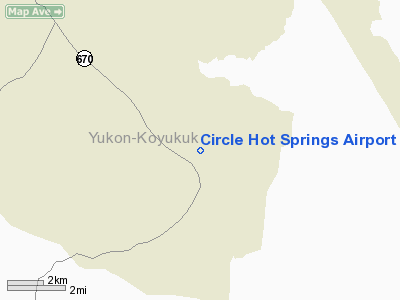
Circle Hot Springs Airport |
| Circle Hot Springs Airport |
| IATA: CHP – ICAO: none – FAA LID: CHP |
| Summary |
| Airport type |
Public |
| Owner |
Alaska DOT&PF - Northern Region |
| Serves |
Circle Hot Springs, Alaska |
| Elevation AMSL |
956 ft / 291 m |
| Coordinates |
65°29′08″N 144°36′39″W / 65.48556°N 144.61083°W / 65.48556; -144.61083 |
| Runways |
| Direction |
Length |
Surface |
| ft |
m |
| 8/26 |
3,650 |
1,113 |
Gravel |
| Statistics (2005) |
| Aircraft operations |
3,600 |
| Source: Federal Aviation Administration |
Circle Hot Springs Airport (IATA: CHP, FAA LID: CHP) is a state-owned public-use airport serving Circle Hot Springs, in the Yukon-Koyukuk Census Area of the U.S. state of Alaska. Facilities and aircraft
Circle Hot Springs Airport covers an area of 37 acres (15 ha) at an elevation of 956 feet (291 m) above mean sea level. It has one runway designated 8/26 with a gravel surface measuring 3,650 by 80 feet (1,113 x 24 m). For the 12-month period ending December 31, 2005, the airport had 3,600 aircraft operations, an average of 300 per month: 72% general aviation and 28% air taxi.
Airlines
The above content comes from Wikipedia and is published under free licenses – click here to read more.
Location & QuickFacts
|
FAA
Information Effective: |
2005-10-27 |
|
Airport Identifier: |
CHP |
|
Longitude/Latitude: |
144-36-38.8210W/65-29-07.7000N
-144.610784/65.485472 (Estimated) |
|
Elevation: |
956
ft / 291.39 m (Surveyed) |
|
Land: |
37
acres |
|
From nearest city: |
0
nautical miles NE of Circle Hot Springs, AK |
|
Location: |
Upper
Yukon County, AK |
|
Magnetic Variation: |
30E
(1985) |
Owner & Manager
|
Ownership: |
Publicly owned |
|
Owner: |
St
Of Ak Dotpf-n Rgn |
|
Address: |
2301
Peger Rd
Fairbanks, AK 99709 |
|
Phone number: |
907-451-2244 |
|
Manager: |
Jay
Bottoms |
|
Address: |
2301
Peger Rd
Fairbanks, AK 99709 |
|
Phone number: |
907-451-2359 |
Airport Operations and Facilities
|
Airport
Use: |
Open to public |
|
Wind indicator: |
Yes |
|
Segmented Circle: |
Yes |
|
Control Tower: |
No |
|
Attendance Schedule: |
UNATNDD |
|
Lighting Schedule: |
RDO-CTL
ACTVT MIRL RY 08/26 & ROTG BCN - CTAF. |
|
Beacon Color: |
Clear-Green
(lighted land airport) |
|
Landing fee charge: |
No |
|
Sectional chart: |
Dawson |
|
Region: |
AAL
- Alaska |
|
Boundary ARTCC: |
ZAN
- Anchorage |
|
Tie-in FSS: |
FAI
- Fairbanks |
|
FSS on Airport: |
No |
|
FSS Phone: |
907-474-0788 |
|
FSS Toll Free: |
1-866-248-6516 |
|
NOTAMs Facility: |
FAI
(NOTAM-d service avaliable) |
|
Federal Agreements: |
NS1 |
Airport Communications
Airport Services
|
Airframe
Repair: |
NONE |
|
Power
Plant Repair: |
NONE |
|
Bottled Oxygen: |
NONE |
|
Bulk Oxygen: |
NONE |
Runway Information
Runway 08/26
|
Dimension: |
3650 x 80 ft / 1112.5
x 24.4 m |
|
Surface: |
GRVL,
Fair Condition
SHALLOW RUTS NEAR RY EDGES, DEEPER RUTS TO 3 INS ON SHOULDERS. SHOULDERS
SOFT WHEN WET.
FROST HEAVING & GRASS TO 6 IN GROWING THROUGH GRAVEL FIRST 1300
FT OF RY 08. |
|
Edge Lights: |
Medium |
|
|
Runway 08 |
Runway 26 |
|
Traffic Pattern: |
Left |
Left |
|
Obstruction: |
60 ft trees, 350.0 ft from runway, 130 ft right
of centerline, 5:1 slope to clear |
58 ft trees, 1440.0 ft from runway, 24:1 slope
to clear |
|
Radio Navigation Aids
|
ID |
Type |
Name |
Ch |
Freq |
Var |
Dist |
Remarks
- RETARDANT
ACFT MAY BE OPERATING FROM ARPT IN SUMMER.
- SNOW
REMOVAL DURING WINTER.
- RY
NOT MAINTAINED & CONDITION NOT MONITORED, RECOMMEND VISUAL INSPECTION
PRIOR TO LANDING.
- RY
08/26 SAFETY AREAS ROUGH & UNEVEN.
- SUAIS
- 125.3 (1-800-758-8723).
Based Aircraft
|
Aircraft
based on field: |
4 |
|
Single Engine Airplanes: |
4 |
Operational Statistics
|
Aircraft
Operations: |
70/Week |
|
Air Taxi: |
27.8% |
|
General Aviation
Local: |
61.1% |
|
General Aviation
Itinerant: |
11.1% |
Circle Hot Springs Airport
Address: Upper
Yukon County, AK
Tel:
907-451-2244,
907-451-2359
Images
and information placed above are from
http://www.airport-data.com/airport/CHP/
We
thank them for the data!
| General
Info |
| Country |
United
States |
| State |
ALASKA
|
| FAA ID |
CHP
|
| Latitude |
65-29-07.700N
|
| Longitude |
144-36-38.821W
|
| Elevation |
956 feet
|
| Near City |
CIRCLE
HOT SPRINGS |
We don't guarantee the information is fresh and accurate. The data may be wrong or outdated.
For more up-to-date information please refer to other sources.
|
|


