 |
|
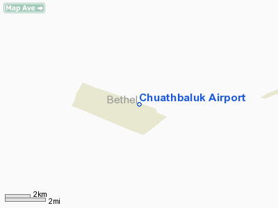
| Chuathbaluk Airport |
| IATA: CHU – ICAO: PACH – FAA LID: 9A3 |
| Summary |
| Airport type |
Public |
| Owner |
State of Alaska DOT&PF |
| Serves |
Chuathbaluk, Alaska |
| Elevation AMSL |
243 ft / 74 m |
| Coordinates |
61°34′45″N 159°12′56″W / 61.57917°N 159.21556°W / 61.57917; -159.21556 |
| Runways |
| Direction |
Length |
Surface |
| ft |
m |
| 9/27 |
3,401 |
1,037 |
Gravel |
| Source: Federal Aviation Administration |
Chuathbaluk Airport (IATA: CHU, ICAO: PACH, FAA LID: 9A3) is a state-owned public-use airport located one nautical mile (1.85 km) northeast of the central business district of Chuathbaluk, a city in the Bethel Census Area of the U.S. state of Alaska. Facilities
Chuathbaluk Airport covers an area of 242 acres (98 ha) at an elevation of 243 feet (74 m) above mean sea level. It has one runway designated 9/27 with a gravel surface measuring 3,401 by 60 feet (1,037 x 18 m).
Airlines
- Hageland Aviation Services
The above content comes from Wikipedia and is published under free licenses – click here to read more.
Chuathbaluk
is a city located in Bethel Census Area, Alaska. As of the 2000 census,
the population of the city is 119.
Chuathbaluk
is located at 61°34'32" North, 159°14'50" West (61.575693,
-159.247311)GR1.
According to the United States
Census Bureau, the city has a total area of 13.9 km² (5.4 mi²).
9.1 km² (3.5 mi²) of it is land and 4.8 km² (1.8 mi²)
of it is water. The total area is 34.26% water.
Location & QuickFacts
|
FAA
Information Effective: |
2005-10-27 |
|
Airport Identifier: |
9A3 |
|
Longitude/Latitude: |
159-12-56.3000W/61-34-44.6000N
-159.215639/61.579056 (Estimated) |
|
Elevation: |
240
ft / 73.15 m (Estimated) |
|
Land: |
0
acres |
|
From nearest city: |
1
nautical miles NE of Chuathbaluk, AK |
|
Location: |
Kuskokwim
County, AK |
|
Magnetic Variation: |
21E
(1985) |
Owner & Manager
|
Ownership: |
Publicly owned |
|
Owner: |
State
Of Alaska Dot |
|
Address: |
Po
Box 196900
Anchorage, AK 99519-6900 |
|
Phone number: |
907-269-0747 |
|
Manager: |
Terry
Hoffman |
|
Address: |
Box
73
Aniak, AK 99557 |
|
Phone number: |
907-675-4345 |
Airport Operations and Facilities
|
Airport
Use: |
Open to public |
|
Wind indicator: |
Yes |
|
Segmented Circle: |
Yes |
|
Control Tower: |
No |
|
Attendance Schedule: |
UNATNDD |
|
Lighting Schedule: |
RDO-CTL
ACTVT ROTG BCN - CTAF |
|
Beacon Color: |
Clear-Green
(lighted land airport) |
|
Sectional chart: |
Mc
Grath |
|
Region: |
AAL
- Alaska |
|
Boundary ARTCC: |
ZAN
- Anchorage |
|
Tie-in FSS: |
ENA
- Kenai |
|
FSS Phone: |
800-478-3576 |
|
FSS Toll Free: |
1-800-WX-BRIEF |
|
NOTAMs Facility: |
ANI
(NOTAM-d service avaliable) |
|
Federal Agreements: |
N |
Airport Communications
Runway Information
Runway 09/27
|
Dimension: |
3400 x 60 ft / 1036.3
x 18.3 m |
|
Surface: |
GRVL,
|
|
Edge Lights: |
Medium |
|
|
Runway 09 |
Runway 27 |
|
Traffic Pattern: |
Left |
Left |
|
Crossing Height: |
26.00 ft |
0.00 ft |
|
VASI: |
4-light PAPI on left side |
4-light PAPI on left side |
|
Visual Glide
Angle: |
3.00� |
0.00� |
|
Runway End
Identifier: |
Yes |
Yes |
|
Radio Navigation Aids
|
ID |
Type |
Name |
Ch |
Freq |
Var |
Dist |
|
ANI |
NDB |
Aniak |
|
359.00 |
18E |
11.0
nm |
Remarks
- RY
COND NOT MONTRD RCMD VISUAL INSPN PRIOR TO USE.
Chuathbaluk
Airport
Address: Kuskokwim
County, AK
Tel:
907-269-0747,
907-675-4345
Images
and information placed above are from
http://www.airport-data.com/airport/9A3/
http://en.wikipedia.org/wiki/Chuathbaluk%2C_Alaska
We
thank them for the data!
| General
Info |
| Country |
United
States |
| State |
ALASKA
|
| FAA ID |
9A3
|
| Latitude |
61-35-02.970N
|
| Longitude |
159-14-09.000W
|
| Elevation |
300 feet
|
| Near City |
CHUATHBALUK
|
We don't guarantee the information is fresh and accurate. The data may be wrong or outdated.
For more up-to-date information please refer to other sources.
|
|


