 |
|
| Chignik Lake Airport |
 |
| IATA: KCQ – ICAO: none – FAA LID: A79 |
| Summary |
| Airport type |
Public |
| Owner |
State of Alaska DOT&PF - Central Region |
| Serves |
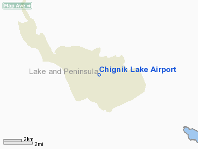
Chignik Lake, Alaska |
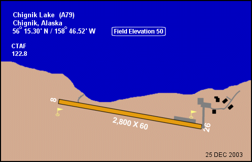
| Elevation AMSL |
50 ft / 15 m |
| Coordinates |
56°15′18″N 158°46′31″W / 56.255°N 158.77528°W / 56.255; -158.77528 |
| Runways |
| Direction |
Length |
Surface |
| ft |
m |
| 8/26 |
2,800 |
853 |
Gravel |
| Statistics (2005) |
| Aircraft operations |
720 |
| Source: Federal Aviation Administration |
Chignik Lake Airport (IATA: KCQ, FAA LID: A79) is a state-owned, public-use airport located at Chignik Lake, in the Lake and Peninsula Borough of the U.S. state of Alaska.
This airport is included in the FAA's National Plan of Integrated Airport Systems (2009-2013), which categorizes it as a general aviation facility. Scheduled airline service to King Salmon Airport is provided by Peninsula Airways (PenAir). Airlines and destinations
Facilities and aircraft
Chignik Lake Airport has one runway designated 8/26 with a gravel surface measuring 2,800 by 60 feet (853 x 18 m). For the 12-month period ending July 31, 2005, the airport had 720 aircraft operations, an average of 60 per month: 69% air taxi and 31% general aviation. The airport is unattended.
The above content comes from Wikipedia and is published under free licenses – click here to read more.
Location & QuickFacts
|
FAA
Information Effective: |
2005-10-27 |
|
Airport Identifier: |
A79 |
|
Longitude/Latitude: |
158-46-31.3010W/56-15-18.1700N
-158.775361/56.255047 (Estimated) |
|
Elevation: |
50 ft / 15.24 m (Estimated) |
|
Land: |
0
acres |
|
From nearest city: |
0 nautical miles
SW of Chignik Lake, AK |
|
Location: |
Aleutian
Islands County, AK |
|
Magnetic Variation: |
19E (1985) |
Owner & Manager
|
Ownership: |
Publicly
owned |
|
Owner: |
State Of Ak Dotpf/c
Rgn |
|
Address: |
Box
196900
Anchorage, AK 99519-6900 |
|
Phone number: |
907-269-0747 |
|
Manager: |
King
Salmon Airport Mgr. |
|
Address: |
Po Box 65
King Salmon, AK 99613 |
|
Phone number: |
907-246-3325 |
Airport Operations and Facilities
|
Airport
Use: |
Open
to public |
|
Wind indicator: |
Yes |
|
Segmented Circle: |
Yes
SEGMENTED CIRCLE OVERGROWN. |
|
Control Tower: |
No |
|
Attendance Schedule: |
UNATNDD |
|
Landing fee charge: |
No |
|
Sectional chart: |
Cold Bay |
|
Region: |
AAL
- Alaska |
|
Boundary ARTCC: |
ZAN - Anchorage |
|
Tie-in FSS: |
ENA
- Kenai |
|
FSS on Airport: |
No |
|
FSS Phone: |
800-478-3576 |
|
FSS Toll Free: |
1-800-WX-BRIEF |
|
NOTAMs Facility: |
AJC
(NOTAM-d service avaliable) |
|
Federal Agreements: |
NGY |
Airport Communications
Airport Services
|
Airframe
Repair: |
NONE |
|
Power
Plant Repair: |
NONE |
|
Bottled Oxygen: |
NONE |
|
Bulk Oxygen: |
NONE |
Runway Information
Runway 08/26
|
Dimension: |
2800
x 60 ft / 853.4 x 18.3 m |
|
Surface: |
GRVL,
Good Condition |
|
|
Runway 08 |
Runway 26 |
|
Traffic Pattern: |
Left |
Left |
|
Obstruction: |
14 ft hill, 350.0 ft from runway, 25:1 slope
to clear |
150 ft hill, 5000.0 ft from runway, 33:1 slope
to clear |
|
Radio Navigation Aids
|
ID |
Type |
Name |
Ch |
Freq |
Var |
Dist |
|
PDN |
NDB/DME |
Port
Heiden |
032X |
371.00 |
19E |
42.2
nm |
Remarks
-
RY SAFETY AREAS ROUGH.
GRADE UNEVEN. SAFETY AREA 3255 FT BY 120 FT.
-
RY 08/26 SLOPES UPHILL
TO BOTH RY THRS; LOW POINT OF RY NEAR W END.
-
RWY COND NOT MONITORED
- RCMD VISUAL INSPN PRIOR TO USE.
-
HILL S OF RY 08/26 150
FT HIGH; RUNS PARALLEL TO RY.
-
PILOTS ARE REQUESTED
TO SELF-ANNOUNCE ON CTAF PRIOR TO TAXIING ON RWY FOR DEPARTURE; LEAVING
THE RWY AND WITHIN 10 NM OF THE ARPT WHEN APPROACHING TO LAND.
Based Aircraft
|
Aircraft
based on field: |
4 |
|
Single Engine Airplanes: |
4 |
Operational Statistics
|
Aircraft
Operations: |
14/Week |
|
Air Taxi: |
69.4% |
|
General Aviation
Local: |
2.8% |
|
General Aviation
Itinerant: |
27.8% |
Chignik
Lake Airport
Address: Aleutian
Islands County, AK
Tel:
907-269-0747,
907-246-3325
Images
and information placed above are from
http://www.airport-data.com/airport/A79/
We
thank them for the data!
| General
Info |
| Country |
United
States |
| State |
ALASKA
|
| FAA ID |
A79
|
| Latitude |
56-15-18.170N
|
| Longitude |
158-46-31.301W
|
| Elevation |
50 feet
|
| Near City |
CHIGNIK
LAKE |
We don't guarantee the information is fresh and accurate. The data may be wrong or outdated.
For more up-to-date information please refer to other sources.
|
|


