|
|
Chignik Bay Seaplane Base |
| Chignik Bay Seaplane Base |
 |
| IATA: KBW – ICAO: none – FAA LID: Z78 |
| Summary |
| Airport type |
Public |
| Owner |
Public Domain |
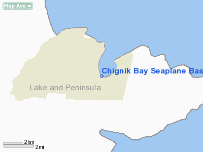
| Serves |
Chignik, Alaska |
| Elevation AMSL |
0 ft / 0 m |
| Coordinates |
56°17′44″N 158°24′05″W / 56.29556°N 158.40139°W / 56.29556; -158.40139 |
| Runways |
| Direction |
Length |
Surface |
| ft |
m |
| E/W |
6,000 |
1,829 |
Water |
| NE/SW |
10,000 |
3,048 |
Water |
| Statistics (2006) |
| Aircraft operations |
210 |
| Source: Federal Aviation Administration |
Chignik Bay Seaplane Base (IATA: KBW, FAA LID: Z78) is a public-use seaplane base serving Chignik, a city in the Lake and Peninsula Borough of the U.S. state of Alaska. Facilities and aircraft
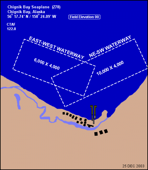
Chignik Bay Seaplane Base has two seaplane landing areas: the E/W waterway is 6,000 by 4,000 feet (1,829 x 1,219 m) and the NE/SW waterway is 10,000 by 4,000 feet (3,048 x 1,219 m). The beach is used for aircraft pull-up. For the 12-month period ending December 31, 2006, the airport had 210 aircraft operations, an average of 17 per month: 95% general aviation and 5% air taxi.
The above content comes from Wikipedia and is published under free licenses – click here to read more.
Location & QuickFacts
|
FAA
Information Effective: |
2005-10-27 |
|
Airport Identifier: |
Z78 |
|
Longitude/Latitude: |
158-24-05.3270W/56-17-44.1980N
-158.401480/56.295611 (Estimated) |
|
Elevation: |
0 ft / 0.00 m (Estimated) |
|
Land: |
0
acres |
|
From nearest city: |
0 nautical miles
N of Chignik, AK |
|
Location: |
Aleutian
Islands County, AK |
|
Magnetic Variation: |
19E (1985) |
Owner & Manager
|
Ownership: |
Publicly
owned |
|
Owner: |
Public Domain |
|
Address: |
|
|
Address: |
|
Airport Operations and Facilities
|
Airport
Use: |
Open
to public |
|
Wind indicator: |
No |
|
Segmented Circle: |
No |
|
Control Tower: |
No |
|
Attendance Schedule: |
UNATNDD |
|
Landing fee charge: |
No |
|
Sectional chart: |
Kodiak |
|
Region: |
AAL - Alaska |
|
Boundary ARTCC: |
ZAN
- Anchorage |
|
Tie-in FSS: |
ENA - Kenai |
|
FSS on Airport: |
No |
|
FSS Phone: |
800-478-3576 |
|
FSS Toll Free: |
1-800-WX-BRIEF |
|
NOTAMs Facility: |
AJC (NOTAM-d service
avaliable) |
Airport Communications
Airport Services
|
Fuel
available: |
80 |
|
Airframe
Repair: |
NONE |
|
Power
Plant Repair: |
NONE |
|
Bottled Oxygen: |
NONE |
|
Bulk Oxygen: |
NONE |
Runway Information
Runway E/W
|
Dimension: |
6000
x 4000 ft / 1828.8 x 1219.2 m |
|
Surface: |
WATER,
|
|
|
Runway E |
Runway W |
|
Traffic Pattern: |
Left |
Left |
|
Markings: |
None, |
None, |
|
Runway End Identifier: |
No |
No |
|
Centerline Lights: |
No |
No |
|
Touchdown Lights: |
No |
No |
|
Runway NE/SW
|
Dimension: |
10000
x 4000 ft / 3048.0 x 1219.2 m |
|
Surface: |
WATER,
|
|
|
Runway NE |
Runway SW |
|
Traffic Pattern: |
Left |
Left |
|
Markings: |
None, |
None, |
|
Runway End Identifier: |
No |
No |
|
Centerline Lights: |
No |
No |
|
Touchdown Lights: |
No |
No |
|
Radio Navigation Aids
|
ID |
Type |
Name |
Ch |
Freq |
Var |
Dist |
|
PDN |
NDB/DME |
Port
Heiden |
032X |
371.00 |
19E |
40.4
nm |
Remarks
Operational Statistics
|
Aircraft
Operations: |
18/Month |
|
Air Taxi: |
4.8% |
|
General Aviation
Itinerant: |
95.2% |
Chignik
Bay Seaplane Base
Address: Aleutian
Islands County, AK
Tel:
Images
and information placed above are from
http://www.airport-data.com/airport/Z78/
We
thank them for the data!
| General
Info |
| Country |
United
States |
| State |
ALASKA
|
| FAA ID |
Z78
|
| Latitude |
56-17-44.198N
|
| Longitude |
158-24-05.327W
|
| Elevation |
0 feet
|
| Near City |
CHIGNIK
|
We don't guarantee the information is fresh and accurate. The data may be wrong or outdated.
For more up-to-date information please refer to other sources.
|
|