 |
|
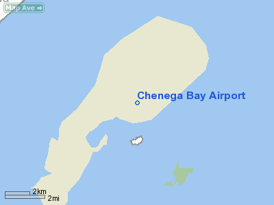
| Chenega Bay Airport |
| IATA: NCN – ICAO: PFCB – FAA LID: C05 |
| Summary |
| Airport type |
Public |
| Owner |
Alaska DOT&PF - Central Region |
| Serves |
Chenega, Alaska |
| Elevation AMSL |
72 ft / 22 m |
| Coordinates |
60°04′38″N 147°59′31″W / 60.07722°N 147.99194°W / 60.07722; -147.99194 |
| Runways |
| Direction |
Length |
Surface |
| ft |
m |
| 15/33 |
3,000 |
914 |
Gravel |
| Source: Federal Aviation Administration |
Chenega Bay Airport (IATA: NCN, ICAO: PFCB, FAA LID: AUK) is a state-owned public-use airport located one nautical mile (1.85 km) northeast of the central business district of Chenega, in the Valdez-Cordova Census Area of the U.S. state of Alaska. Facilities
Chenega Bay Airport covers an area of 123 acres (50 ha) at an elevation of 72 feet (22 m) above mean sea level. It has one runway designated 15/33 with a gravel surface measuring is 3,000 by 75 feet (914 x 23 m).
Airline and destinations
- Arctic Circle Air (Anchorage)
The above content comes from Wikipedia and is published under free licenses – click here to read more.
Chenega Bay is a unincorporated community in the Valdez-Cordova
Census Area, Alaska, USA on Crab Bay on Evans Island along Prince William
Sound. The town has about 80 inhabitants, largely consisting of Chugach
Alutiq Native Americans.
Chenega Bay
was established in 1984 as the result of a search for a place for former
residents of Chenega, Alaska to live in. Chenega was largely destroyed
in 1964 by a tsunami from the Alaska Earthquake, which killed 1/3 of the
68 people who then lived there.
In 1982, one family
moved to Evans Island and between 1984 and 1991 about 26 other families
migrated to Chenega Bay. As not all the residents moved
to Chenega Bay, old Chenega still exists as a village.
The population of
Chenega Bay suffered economically following the 1989
Exxon Valdez oil spill, as it killed much of the marine life around Evans
Island.
Location & QuickFacts
|
FAA
Information Effective: |
2005-10-27 |
|
Airport Identifier: |
C05 |
|
Longitude/Latitude: |
147-59-30.8000W/60-04-38.3000N
-147.991889/60.077306 (Estimated) |
|
Elevation: |
72 ft / 21.95 m (Estimated) |
|
Land: |
123
acres |
|
From nearest city: |
1 nautical miles
NE of Chenega, AK |
|
Location: |
Seward
County, AK |
|
Magnetic Variation: |
25E (1990) |
Owner & Manager
|
Ownership: |
Publicly
owned |
|
Owner: |
State Of Ak Dotpf/ce
Region |
|
Address: |
Po
Box 19690
Anchorage, AK 99519-6900 |
|
Phone number: |
907-262-5762 |
|
Manager: |
Bob
Bondurant/carl High |
|
Address: |
P. O. Box 1327
Soldotna, AK 99669 |
|
Phone number: |
907-262-5762 |
Airport Operations and Facilities
|
Airport
Use: |
Open
to public |
|
Wind indicator: |
Yes |
|
Segmented Circle: |
Yes |
|
Control Tower: |
No |
|
Attendance Schedule: |
UNATNDD |
|
Sectional chart: |
Seward |
|
Region: |
AAL - Alaska |
|
Boundary ARTCC: |
ZAN
- Anchorage |
|
Tie-in FSS: |
JNU - Juneau |
|
FSS Phone: |
907-586-7380 |
|
FSS Toll Free: |
1-800-WX-BRIEF |
|
NOTAMs Facility: |
CDV
(NOTAM-d service avaliable) |
|
Federal Agreements: |
NGY |
Airport Communications
Runway Information
Runway 15/33
|
Dimension: |
3000
x 75 ft / 914.4 x 22.9 m |
|
Surface: |
GRAVEL, Good Condition
SHOULDERS AND SAFETY AREAS SOFT WHEN WET. WATER PONDS IN SAFETY
AREAS AT BOTH ENDS |
|
|
Runway 15 |
Runway 33 |
|
Traffic Pattern: |
Left |
Left |
|
Obstruction: |
109 ft trees, 1300.0 ft from runway, 12:1 slope to clear |
37 ft trees, 800.0 ft from runway, 170 ft right of centerline,
21:1 slope to clear |
|
Radio Navigation Aids
|
ID |
Type |
Name |
Ch |
Freq |
Var |
Dist |
|
ALJ |
NDB |
Orca
Bay |
|
233.00 |
23E |
48.3
nm |
|
JOH |
VOR/DME |
Johnstone Point |
114X |
116.70 |
27E |
48.1
nm |
Remarks
-
PILOTS ARE REQUESTED
TO SELF-ANNOUNCE ON CTAF PRIOR TO TAXIING ON RWY FOR DEPARTURE; LEAVING
THE RWY AND WITHIN 10 NM OF THE ARPT WHEN APPROACHING TO LAND.
-
PORTABLE RUNWAY LIGHTS
AVAILABLE FOR EMERGENCY USE ONLY. CONTACT HEALTH CLINIC FOR DEPLOYMENT.
Based Aircraft
|
Aircraft
based on field: |
1 |
|
Single Engine Airplanes: |
1 |
Chenega
Bay Airport
Address: Seward
County, AK
Tel:
907-262-5762
Images
and information placed above are from
http://www.airport-data.com/airport/C05/
http://en.wikipedia.org/wiki/Chenega_Bay%2C_Alaska
We
thank them for the data!
| General
Info |
| Country |
United
States |
| State |
ALASKA
|
| FAA ID |
C05
|
| Latitude |
60-04-38.300N
|
| Longitude |
147-59-30.800W
|
| Elevation |
72 feet
|
| Near City |
CHENEGA
|
We don't guarantee the information is fresh and accurate. The data may be wrong or outdated.
For more up-to-date information please refer to other sources.
|
|


