|
|
Cape Lisburne Long Range Radar Site Airport |
| Cape Lisburne LRRS Airport |
 |
| IATA: LUR – ICAO: PALU – FAA LID: LUR |
| Summary |
| Airport type |
Military |
| Owner |
U.S. Air Force |
| Location |
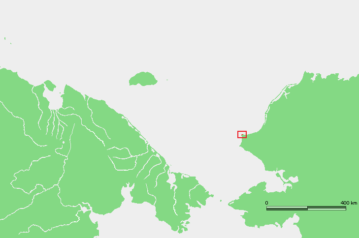
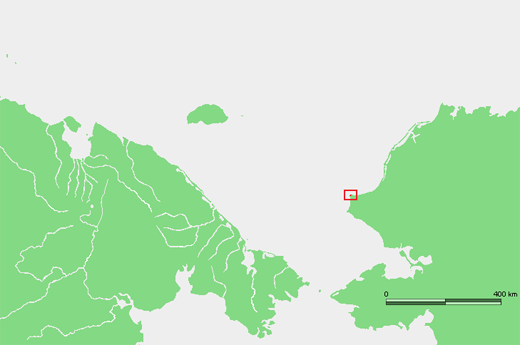
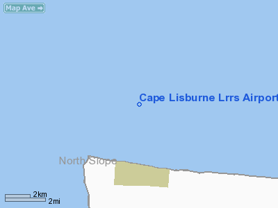
Cape Lisburne, Alaska |
| Elevation AMSL |
12 ft / 4 m |
| Coordinates |
68°52′30″N 166°06′36″W / 68.875°N 166.11°W / 68.875; -166.11 |
| Runways |
| Direction |
Length |
Surface |
| ft |
m |
| 8/26 |
4,800 |
1,463 |
Gravel |
| Statistics (1977) |
| Aircraft operations |
200 |
| Source: Federal Aviation Administration |
Cape Lisburne LRRS Airport (IATA: LUR, ICAO: PALU, FAA LID: LUR) is a military airport located on Cape Lisburne, at the northwest point of the Lisburne Peninsula in the North Slope Borough of the U.S. state of Alaska. The airport is owned by the U.S. Air Force. It is also known as Cape Lisburne Airport. The acronym LRRS stands for Long Range Radar Site or Long Range Radar Station.
This airstrip supports the Cape Lisburne LRRS, a Distant Early Warning Line (DEW Line) radar station located within the Alaska Maritime National Wildlife Refuge in northwestern Alaska, between the Arctic Ocean and the Chuckchi Sea. The nearest community is Point Hope, located 25 miles (40 km) to the southwest. Facilities and aircraft
Cape Lisburne LRRS Airport has one runway designated 8/26 with a gravel surface measuring 4,800 by 135 feet (1,463 x 41 m). For the 12-month period ending July 12, 1977, the airport had 200 aircraft operations, an average of 16 per month, all of which were general aviation.
Airline and destinations
The above content comes from Wikipedia and is published under free licenses – click here to read more.
Location & QuickFacts
|
FAA
Information Effective: |
2005-10-27 |
|
Airport Identifier: |
LUR |
|
Longitude/Latitude: |
166-06-36.0760W/68-52-30.4760N
-166.110021/68.875132 (Estimated) |
|
Elevation: |
12 ft / 3.66 m (Surveyed) |
|
Land: |
0
acres |
|
From nearest city: |
0 nautical miles
N of Cape Lisburne, AK |
|
Location: |
Barrow
County, AK |
|
Magnetic Variation: |
17E (1985) |
Owner & Manager
|
Ownership: |
Air
Force owned |
|
Owner: |
U.s. Air Force |
|
Address: |
11
Air Force Elmendorf Afb
Anchorage, AK 99506-2270 |
|
Manager: |
Comdr |
|
Address: |
11
Tcw 6900 9th St Ste 301
Elemendorf Afb, AK 99506-2270 |
|
Phone number: |
907-725-1203 |
Airport Operations and Facilities
|
Wind indicator: |
Yes |
|
Segmented Circle: |
No |
|
Control Tower: |
No |
|
Attendance Schedule: |
ALL/ALL/DALGT
NORMALLY ATNDD 0800-1700 WKDAYS. |
|
Lighting Schedule: |
RDO-CTL
ACTVT HIRL RY 08/26, TWY & RAMP EDGE LGTS,RY HOLD/END LGTS,
DISTANCE REMAINING LGTS, TDZE LGTD PANELS IN GREEN AT THLDS - WHITE
AT TOUCHDOWN POINTS - RED AT RY END - 126.2. PAPI REIL OPERATE 24
HRS. |
|
Beacon Color: |
Clear-Green-Yellow
(heliport)
ROTG BCN ON REQUEST. |
|
Landing fee charge: |
No |
|
Sectional chart: |
Cape Lisburne |
|
Region: |
AAL
- Alaska |
|
Boundary ARTCC: |
ZAN - Anchorage |
|
Tie-in FSS: |
OTZ
- Kotzebue |
|
FSS on Airport: |
No |
|
FSS Phone: |
907-442-3310 |
|
FSS Toll Free: |
1-478-7460 |
|
Alternate FSS: |
FAI
- Fairbanks |
|
Alt. FSS Toll Free: |
1-866-248-6516 |
|
NOTAMs Facility: |
OTZ
(NOTAM-d service avaliable) |
Airport Communications
Airport Services
|
Airframe
Repair: |
NONE |
|
Power
Plant Repair: |
NONE |
|
Bottled Oxygen: |
NONE |
|
Bulk Oxygen: |
NONE |
Runway Information
Runway 08/26
|
Dimension: |
4800
x 135 ft / 1463.0 x 41.1 m |
|
Surface: |
GRAVEL, |
|
Edge Lights: |
High |
|
|
Runway 08 |
Runway 26 |
|
Traffic Pattern: |
Left |
Right |
|
VASI: |
4-light PAPI on left side |
4-light PAPI on left side |
|
Runway End Identifier: |
Yes |
Yes |
|
Centerline Lights: |
No |
No |
|
Touchdown Lights: |
No |
No |
|
Radio Navigation Aids
|
ID |
Type |
Name |
Ch |
Freq |
Var |
Dist |
|
PHO |
NDB |
Point
Hope |
|
221.00 |
16E |
35.3
nm |
|
LUR |
NDB/DME |
Cape
Lisburne |
20Y |
385.00 |
16E |
0.8
nm |
Remarks
-
PASSENGERS MUST COORDINATE
ALL TRAVEL WITH ARS PROGRAM MANAGEMENT (DSN 317-552-4400/1989 OR C907-552-4400/1989)
ON ALL NON-EMERGENCY TRAVEL TO SITE.
-
CAUTION; SFC WNDS FM
090 THRU 270 DEGS IN EXCESS OF 10 KTS ( RANDOM WNDS IN EXCESS OF 25
KTS) MAY PRODUCE SEVERE TURBULANCE.
-
RADOME WINDS AVBL.
-
AFTER INITIAL RADIO CONTACT
ON FREQ 126.2 OR 121.5 EXPECT A 30 MIN DELAY FOR CURRENT AIRSTRIP CONDITION.
-
DAYLGT OPNS ONLY.
-
SEA-BIRDS OFF END OF
RWY 08.
-
USAF INSTALLATION, ALL
CIVIL ACFT OPERS REQ CIVIL ACFT LNDG PERMITS PRIOR TO LANDING AT FACILITY.
FINES WILL BE LEVIED AGAINST VIOLATORS & REPORTS WILL BE FWDD TO
FAA FSDOS IAW 32CFR855 & USAF OPERG INSTRGS. OPERS MUST HAVE ON
BOARD A COPY OF CURRENT PERMIT. FOR PERMITS CALL 907-552-7384/3636/5265.
-
ALL MIL, GOVT AND CIV
ACFT OPERATORS SHALL OBTAIN A PPR CTL NR A MIN OF 1-HR PRIOR TO DEP
FOR SITE, REQUEST NO EARLIER THAN DAY OF PLANNED TRAVEL, CTC SITE PERSONNEL
AT: DSN 317-552-9730/9637 C907-552-9730/9637. AFLD IS CLSD WEEKENDS
AND ALL FEDERAL HOL.
Operational Statistics
|
Aircraft
Operations: |
17/Month |
|
General Aviation
Itinerant: |
100.0% |
Cape Lisburne Lrrs Airport
Address: Barrow
County, AK
Tel:
907-725-1203
Images
and information placed above are from
http://www.airport-data.com/airport/LUR/
We
thank them for the data!
| General
Info |
| Country |
United
States |
| State |
ALASKA
|
| FAA ID |
LUR
|
| Latitude |
68-52-30.476N
|
| Longitude |
166-06-36.076W
|
| Elevation |
12 feet
|
| Near City |
CAPE LISBURNE
|
We don't guarantee the information is fresh and accurate. The data may be wrong or outdated.
For more up-to-date information please refer to other sources.
|
|