|
|
| Bethel Airport |
 |
| IATA: BET – ICAO: PABE – FAA LID: BET |
| Summary |
| Airport type |
Public |
| Owner |
State of Alaska DOT&PF - Central Region |
| Location |
Bethel, Alaska |
| Elevation AMSL |
126 ft / 38 m |
| Coordinates |
60°46′47″N 161°50′17″W / 60.77972°N 161.83806°W / 60.77972; -161.83806 |
| Runways |
| Direction |
Length |
Surface |
| ft |
m |
| 18/36 |
6,400 |
1,951 |
Asphalt |
| 11/29 |
1,860 |
567 |
Gravel |
| Statistics (2007) |
| Aircraft operations |
122,000 |
| Based aircraft |
232 |
| Source: Federal Aviation Administration |
Bethel Airport (IATA: BET, ICAO: PABE, FAA LID: BET) is a state-owned public-use airport located three nautical miles (6 km) southwest of the central business district of Bethel, a city in the Bethel Census Area of the U.S. state of Alaska. Facilities and aircraft
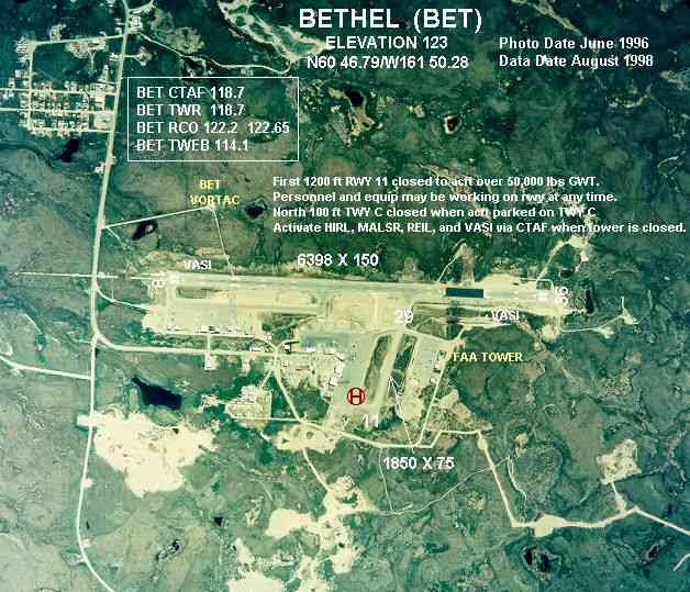
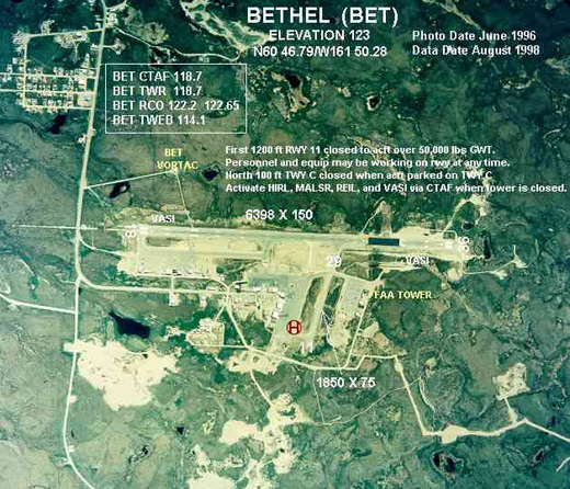
Bethel Airport covers an area of 1,056 acres (427 ha) at an elevation of 126 feet (38 m) above mean sea level. It has two runways: 18/36 with a 6,400 x 150 ft (1,951 x 46 m) asphalt pavement and 11/29 with a 1,860 x 75 ft (567 x 23 m) gravel surface.
For the 12-month period ending June 22, 2007, the airport had 122,000 aircraft operations, an average of 334 per day: 54% air taxi, 41% general aviation, 4% scheduled commercial and 1% military. At that time there were 232 aircraft based at this airport: 90% single engine, 7% multi-engine, 2% helicopters and 1% military.
Airlines and non-stop destinations
- Alaska Airlines (Anchorage)
- Era Aviation (Anchorage)
- Frontier Flying Service (Anchorage, Klaskag)
- Hageland Aviation Services (Chefornak, Chevak, Eek, Kalskag, Kasigluk, Kwethluk, Kwigillingok, Marshall, Russian Mission, St. Mary's, Tuntutuliak)
Cargo airlines
- Alaska Central Express
- Arctic Transportation Services
- Lynden Air Cargo
- Northern Air Cargo
The above content comes from Wikipedia and is published under free licenses – click here to read more.

Location & QuickFacts
|
FAA
Information Effective: |
2005-10-27 |
|
Airport Identifier: |
BET |
|
Longitude/Latitude: |
161-50-16.7910W/60-46-47.1950N
-161.837998/60.779776 (Estimated) |
|
Elevation: |
123 ft / 37.49 m
(Surveyed) |
|
Land: |
1056
acres |
|
From nearest city: |
3 nautical miles
SW of Bethel, AK |
|
Location: |
Bethel
County, AK |
|
Magnetic Variation: |
18E (1985) |
Owner & Manager
|
Ownership: |
Publicly
owned |
|
Owner: |
State Of Ak Dotpf-central
Rgn |
|
Address: |
Po
Box 196900
Anchorage, AK 99519-6900 |
|
Phone number: |
907-269-0747 |
|
Manager: |
L.j.
Davis |
|
Address: |
Box 505
Bethel, AK 99559 |
|
Phone number: |
907-543-2495 |
Airport Operations and Facilities
|
Airport
Use: |
Open
to public |
|
Wind indicator: |
Yes |
|
Segmented Circle: |
Yes |
|
Control Tower: |
Yes |
|
Attendance Schedule: |
OCT-APR/ALL/0500-2130,MAY-SEP/ALL/0630-2130 |
|
Lighting Schedule: |
DUSK-DAWN
WHEN ATCT CLSD ACTVT TWY LIGHTS & HIRL RY 18/36 & MIRL RY
11/29 - CTAF. ACTVT MALSR RY 18 & 36 AND VASI RYS 18 & 36
AND REIL RY 36 - CTAF. |
|
Beacon Color: |
Clear-Green (lighted
land airport) |
|
Sectional chart: |
Mc
Grath |
|
Region: |
AAL - Alaska |
|
Boundary ARTCC: |
ZAN
- Anchorage |
|
Tie-in FSS: |
ENA - Kenai |
|
FSS on Airport: |
No |
|
FSS Phone: |
800-478-3576 |
|
FSS Toll Free: |
1-800-WX-BRIEF |
|
NOTAMs Facility: |
BET (NOTAM-d service
avaliable) |
|
Certification type/date: |
AS
5/1973
ARFF EQUIPMENT STAFFED ONLY DURING ACR OPNS WITH MORE THAN 30 PASSENGER
SEATS. |
|
Federal Agreements: |
N |
Airport Communications
Airport Services
|
Fuel
available: |
100
100LLA A1
SERVICE CHARGE FOR FUEL (25.00) AFTER 1800 DAILY. |
|
Airframe
Repair: |
MINOR |
|
Power
Plant Repair: |
MINOR |
Runway Information
Runway 11/29
|
Dimension: |
1850
x 75 ft / 563.9 x 22.9 m |
|
Surface: |
GRVL,
Good Condition
4 IN TO 8 IN DIPS 1100-1700 FT N OF AER 36. |
|
Edge Lights: |
Medium |
|
|
Runway 11 |
Runway 29 |
|
Longitude: |
161-50-51.5820W |
161-50-22.3880W |
|
Latitude: |
60-46-52.6610N |
60-46-41.3360N |
|
Elevation: |
120.00 ft |
122.00 ft |
|
Alignment: |
127 |
127 |
|
Traffic Pattern: |
Left |
Left |
|
Obstruction: |
168 ft ant, 5600.0 ft from runway, 200 ft left of centerline,
33:1 slope to clear |
,
50:1 slope to clear |
|
Runway 18/36
|
Dimension: |
6398
x 150 ft / 1950.1 x 45.7 m |
|
Surface: |
ASPH,
Fair Condition
4 IN TO 8 IN DIPS 1100-1700 FT N OF AER 36. |
|
Surface Treatment: |
Saw-cut
or plastic Grooved |
|
Weight Limit: |
Single wheel: 90000 lbs.
Dual wheel: 112000 lbs.
Dual tandem wheel: 210000 lbs. |
|
Edge Lights: |
High |
|
|
Runway 18 |
Runway 36 |
|
Longitude: |
161-49-45.2880W |
161-50-36.5970W |
|
Latitude: |
60-47-16.1500N |
60-46-18.3520N |
|
Elevation: |
97.00 ft |
122.00 ft |
|
Alignment: |
127 |
23 |
|
ILS Type: |
ILS/DME |
MLS |
|
Traffic Pattern: |
Left |
Left |
|
Markings: |
Precision instrument, Fair Condition |
Precision instrument, Fair Condition |
|
Crossing Height: |
47.00 ft |
47.00 ft |
|
VASI: |
4-box on left side |
4-box on left side |
|
Visual Glide Angle: |
3.00� |
3.00� |
|
RVR Equipment: |
touchdown
TOUCHDOWN RVR AVBL 0700-2000 1 NOV-30 MAR, 1 APR-31 OCT 0700-2200. |
touchdown
TOUCHDOWN RVR AVBL 0700-2000 1 NOV-30 MAR, 1 APR-31 OCT 0700-2200. |
|
Approach lights: |
MALSR |
MALSR |
|
Runway End Identifier: |
|
No |
|
Radio Navigation Aids
|
ID |
Type |
Name |
Ch |
Freq |
Var |
Dist |
|
ET |
NDB |
Bethel |
|
344.00 |
19E |
1.1
nm |
|
OSE |
NDB |
Oscarville |
|
251.00 |
19E |
1.2
nm |
|
BET |
VORTAC |
Bethel |
088X |
114.10 |
19E |
0.5
nm |
Remarks
-
FIRST 1200' RWY 11 CLSD
TO ACFT OVER 12,500 LBS GWT.
-
REPORTING FOR RY CONDITIONS
AVBL DURING MAINTENANCE DUTY HRS ONLY.
-
BETHEL ARPT WX INFO AVBL
ON 122.0 (CALL SIGN BETHEL WEATHER) 1 APR - 31 OCT 2200-0000; 1 NOV
- 31 MAR 2100-0000.
-
6 TO 8 INCH DIPS AER
36 BTN 1400 FT TO 1600 FT 55 FT FM CNTRLN.
-
NG OPR HRS MON-FRI 0900-1800;
CLSD MOST WKENDS & HOLS. LTD NG TRANS FAC/PARKING/HGR SPACE. PPR
FOR ALL NG ACFT REQUIRING PARKING/FUEL/SVCS. CTC NG OPS 124.65; 64.70
OR PHONE (907) 543-2863/2225.
-
NO SNOW REMOVAL OR DEICING
- 1630-0630 MON-SAT; 1630-1200 SUN.
-
SNOW REMOVAL ICE REMOVAL
& ARPT HAZ RPRTNG ONLY PERFORMED DURG DUTY HRS UNLESS BY PRIOR ARNGMT
IN WRITING WITH ARPT MANAGEMENT.
-
N APRON CLSD TO ACFT
OVER 12,500 LBS.
-
PERSONNEL AND EQUIPMENT
MAY BE WORKING ON THE RY AT ANY TIME.
-
NUMEROUS PTARMIGAN/WATERFOWL
VCNTY OF ARPT.
Based Aircraft
|
Aircraft
based on field: |
232 |
|
Single Engine Airplanes: |
209 |
|
Multi Engine Airplanes: |
17 |
|
Helicopters: |
4 |
|
Military: |
2 |
Major Carriers Serving This
Airport
Most Popular Destinations
|
Ted Stevens Anchorage Intl (ANC) |
72.7% |
|
Kodiak (ADQ) |
27.3% |
Most Popular Aircraft
|
N745AS |
23.5% |
|
N747AS |
19.4% |
|
N741AS |
14.5% |
|
N746AS |
13.1% |
|
N742AS |
9.7% |
|
N740AS |
6.6% |
|
N730AS |
6.6% |
|
000000 |
4.2% |
|
N754AS |
0.7% |
|
N797AS |
0.3% |
Operational Statistics
|
Aircraft
Operations: |
349/Day |
|
Air Carrier: |
4.1% |
|
Air Taxi: |
51.8% |
|
General Aviation
Local: |
5.6% |
|
General Aviation
Itinerant: |
33.4% |
|
Military: |
1.1% |
Bethel Airport
Address: Bethel
County, AK
Tel:
907-269-0747.
07-543-2495
Images
and information placed above are from
http://www.airport-data.com/airport/BET/
We
thank them for the data!
| General
Info |
| Country |
United
States |
| State |
ALASKA
|
| FAA ID |
BET
|
| Latitude |
60-46-47.195N
|
| Longitude |
161-50-16.791W
|
| Elevation |
123 feet
|
| Near City |
BETHEL
|
We don't guarantee the information is fresh and accurate. The data may be wrong or outdated.
For more up-to-date information please refer to other sources.
|
|