 |
|
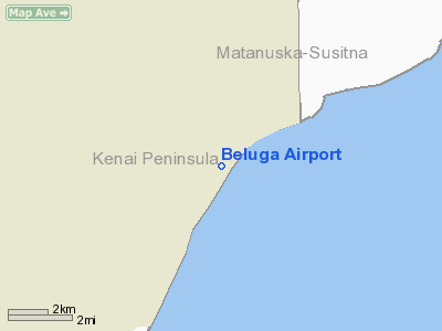
| Beluga Airport |
| IATA: BVU – ICAO: PABG – FAA LID: BLG |
| Summary |
| Airport type |
Private |
| Owner |
ARCO Alaska, Inc. |
| Serves |
Beluga, Alaska |
| Elevation AMSL |
130 ft / 40 m |
| Coordinates |
61°10′20″N 151°02′38″W / 61.17222°N 151.04389°W / 61.17222; -151.04389 |
| Runways |
| Direction |
Length |
Surface |
| ft |
m |
| 18/36 |
5,000 |
1,524 |
Gravel |
| 9/27 |
2,400 |
732 |
Gravel |
| Statistics (1993) |
| Aircraft operations |
5,600 |
| Source: Federal Aviation Administration |
Beluga Airport (IATA: BVU, ICAO: PABG, FAA LID: BLG) is a private-use airport located in Beluga, in the Kenai Peninsula Borough of the U.S. state of Alaska. It is privately owned by ARCO Alaska, Inc.
As per Federal Aviation Administration records, this airport had 4,407 passenger boardings (enplanements) in calendar year 2005 and 6,308 enplanements (all unscheduled) in 2006.
Although most U.S. airports use the same three-letter location identifier for the FAA and IATA, this airport is assigned BLG by the FAA and BVU by the IATA (which assigned BLG to Belaga Airport in Belaga, Sarawak, Malaysia).
Facilities and aircraft
Beluga Airport has two gravel surfaced runways: 18/36 measuring 5,000 x 100 ft (1,524 x 30 m) and 9/27 measuring 2,400 x 60 ft (732 x 18 m). As per the most recent FAA records, for the 12-month period ending January 15, 1993, the airport had 5,600 aircraft operations, an average of 15 per day: 91% general aviation and 9% air taxi.
The above content comes from Wikipedia and is published under free licenses – click here to read more.
Beluga
is a census-designated place (CDP) located in Kenai Peninsula Borough,
Alaska, U.S., at the 2000 census the population was 32.
Beluga is located at 61°8'2'N, 151°9'53'W
(61.133962, -151.164741)GR1.
According to the United States Census Bureau, the CDP
has a total area of 267.8 km² (103.4 mi²). 265.9 km² (102.7
mi²) of it is land and 1.9 km² (0.7 mi²) of it (0.72%)
is water.
Location & QuickFacts
|
FAA
Information Effective: |
2005-10-27 |
|
Airport Identifier: |
BLG |
|
Longitude/Latitude: |
151-02-38.0310W/61-10-19.9880N
-151.043897/61.172219 (Estimated) |
|
Elevation: |
130 ft / 39.62 m
(Estimated) |
|
Land: |
0
acres |
|
From nearest city: |
0 nautical miles
of Beluga, AK |
|
Location: |
Kenai-cook
Inlet County, AK |
|
Magnetic Variation: |
24E (1985) |
Owner & Manager
|
Ownership: |
Privately
owned |
|
Owner: |
Arco Alaska Inc |
|
Address: |
Po
Box 100360
Anchorage, AK 99510 |
|
Phone number: |
907-276-1215 |
|
Manager: |
Beluga
Staff Manager
OR CTC ALLEN APPLEHAMS OR DELMA JACKSON ON 907-263-3930. |
|
Address: |
Po Box 100360
Anchorage, AK 99510 |
|
Phone number: |
907-263-4304 |
Airport Operations and Facilities
|
Airport
Use: |
Private |
|
Wind indicator: |
Yes |
|
Segmented Circle: |
No |
|
Control Tower: |
No |
|
Attendance Schedule: |
ALL/ALL/ALL |
|
Lighting Schedule: |
RDO-CTL
ACTVT MIRL RY 09/27 & 18/36 - CTAF. |
|
Landing fee charge: |
No |
|
Sectional chart: |
Anchorage |
|
Region: |
AAL - Alaska |
|
Boundary ARTCC: |
ZAN
- Anchorage |
|
Tie-in FSS: |
ENA - Kenai |
|
FSS on Airport: |
No |
|
FSS Phone: |
800-478-3576 |
|
FSS Toll Free: |
1-800-WX-BRIEF |
Airport Communications
|
CTAF: |
122.700 |
|
Unicom: |
122.800
|
Airport Services
|
Airframe
Repair: |
NONE |
|
Power
Plant Repair: |
NONE |
|
Bottled Oxygen: |
NONE |
|
Bulk Oxygen: |
NONE |
Runway Information
Runway 09/27
|
Dimension: |
2400
x 60 ft / 731.5 x 18.3 m |
|
Surface: |
GRVL,
|
|
Edge Lights: |
Medium |
|
|
Runway 09 |
Runway 27 |
|
Traffic Pattern: |
Left |
Left |
|
Runway 18/36
|
Dimension: |
5000
x 100 ft / 1524.0 x 30.5 m |
|
Surface: |
GRVL,
Good Condition |
|
Edge Lights: |
Medium |
|
|
Runway 18 |
Runway 36 |
|
Traffic Pattern: |
Left |
Left |
|
Runway End Identifier: |
No |
No |
|
Centerline Lights: |
No |
No |
|
Touchdown Lights: |
No |
No |
|
Radio Navigation Aids
|
ID |
Type |
Name |
Ch |
Freq |
Var |
Dist |
|
GRP |
NDB |
Granite Point |
|
356.00 |
24E |
15.2
nm |
|
BOB |
NDB |
Bruck |
|
387.00 |
21E |
25.1
nm |
|
CMQ |
NDB |
Campbell Lake |
|
338.00 |
21E |
28.9
nm |
|
IWW |
NDB |
Wildwood |
|
379.00 |
20E |
34.8
nm |
|
DRF |
NDB |
Drift
River |
|
368.00 |
24E |
47.3
nm |
|
OLT |
NDB/DME |
Soldotna |
106X |
346.00 |
24E |
42.2
nm |
|
EDF |
TACAN |
Elmendorf |
081X |
|
21E |
37.2
nm |
|
ANC |
VOR/DME |
Anchorage |
090X |
114.30 |
25E |
24.3
nm |
|
ENA |
VOR/DME |
Kenai |
123X |
117.60 |
25E |
33.8
nm |
|
BGQ |
VORTAC |
Big
Lake |
072X |
112.50 |
25E |
39.1
nm |
|
ANC |
VOT |
Anchorage |
|
108.40 |
|
30.7
nm |
|
MRI |
VOT |
Merrill |
|
111.00 |
|
34.8
nm |
Remarks
-
PPR TO LAND CALL AMGR
907-263-3930; IF UNABLE CALL 276-1215.
-
UNCONTROLLED VEHICLES
OPERATING ON SERVICE ROAD ALONG EAST SIDE OF RY.
-
ROAD CROSSES ADJACENT
TO NORTH END OF RY 18.
-
BRUSH MAY HINDER DRIVERS
FROM SEEING APPROACHING ACFT ON AER 18.
-
WILDLIFE ON AND INVOF
AIRPORT.
-
WEST SIDE OF TY DOES
NOT HAVE SHOULDER BYD RY EDGE LIGHTS. SHOULDER AREA ON WEST AND NORTH
SIDE OF RY SOGGY AT TIMES. RY 18 FIRST 200 FT SOFT & UNSTABLE.
-
ENTIRE RY NOT VISIBLE
BY PERSONNEL ON DUTY.
Based Aircraft
|
Aircraft
based on field: |
1 |
|
Single Engine Airplanes: |
1 |
Operational Statistics
|
Aircraft
Operations: |
108/Week |
|
Air Taxi: |
8.9% |
|
General Aviation
Local: |
1.8% |
|
General Aviation
Itinerant: |
89.3% |
Beluga Airport
Address: Kenai-cook
Inlet County, AK
Tel:
907-276-1215.
907-263-4304
Images
and information placed above are from
http://www.airport-data.com/airport/BLG/
http://en.wikipedia.org/wiki/Beluga%2C_Alaska
We thank them for the data!
| General
Info |
| Country |
United
States |
| State |
ALASKA
|
| FAA ID |
BLG
|
| Latitude |
61-10-19.988N
|
| Longitude |
151-02-38.031W
|
| Elevation |
130 feet
|
| Near City |
BELUGA
|
We don't guarantee the information is fresh and accurate. The data may be wrong or outdated.
For more up-to-date information please refer to other sources.
|
|


