|
|
Barter Island Long Range Radar Site Airport |
| Barter Island LRRS Airport |
 |
| IATA: BTI – ICAO: PABA – FAA LID: BTI |
| Summary |
| Airport type |
Public / Military |
| Owner |
North Slope Borough |
| Location |
Barter Island, Alaska |
| Elevation AMSL |
2 ft / 1 m |
| Coordinates |
70°08′02″N 143°34′55″W / 70.13389°N 143.58194°W / 70.13389; -143.58194 |
| Runways |
| Direction |
Length |
Surface |
| ft |
m |
| 7/25 |
4,820 |
1,469 |
Gravel |
| Statistics (2005) |
| Aircraft operations |
3,350 |
| Source: Federal Aviation Administration |
Barter Island LRRS Airport (IATA: BTI, ICAO: PABA, FAA LID: BTI) is a public/military airport located near the city of Kaktovik on Barter Island, in the North Slope Borough of the U.S. state of Alaska. The airport is owned by the North Slope Borough. It is also known as Barter Island Airport or Kaktovik Airport. The acronym LRRS stands for Long Range Radar Site or Long Range Radar Station. History
The original runway was built by the United States military in 1947. The U.S. Air Force assumed control of Barter Island in 1951 and extended the runway in 1953 as part of the installation of a Distant Early Warning Line (DEW Line) radar station.
Facilities and aircraft
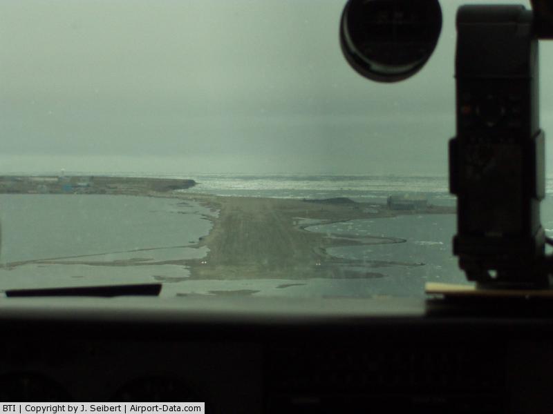
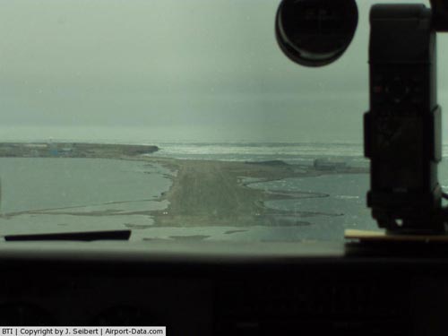
Barter Island LRRS Airport has one runway designed 7/25 with a gravel surface measuring 4,820 by 100 feet (1,469 x 30 m). For the 12-month period ending December 31, 2005, the airport had 3,350 aircraft operations, an average of 9 per day: 75% air taxi, 24% general aviation and 1% military.
Airlines and non-stop destinations
| Airlines |
Destinations |
| Frontier Flying Service |
Deadhorse, Fairbanks
|
| Hageland Aviation Services |
Deadhorse |
The above content comes from Wikipedia and is published under free licenses – click here to read more.
Barter Island
is an island located on the Alaskan Arctic coast east of Arey Island.
The island is long four miles across.
Location & QuickFacts
|
FAA
Information Effective: |
2005-10-27 |
|
Airport Identifier: |
BTI |
|
Longitude/Latitude: |
143-34-37.3600W/70-08-02.0500N
-143.577044/70.133903 (Estimated) |
|
Elevation: |
5 ft / 1.52 m (Estimated) |
|
Land: |
0
acres |
|
From nearest city: |
2 nautical miles
S of Barter Island Lrrs, AK |
|
Location: |
Upper
Yukon County, AK |
|
Magnetic Variation: |
31E (2000) |
|
 |
(Click on the photo to
enlarge) |
Owner & Manager
|
Ownership: |
Air
Force owned |
|
Owner: |
North Slope Borough |
|
Address: |
Po
Box 69
Barrow, AK 99723 |
|
Phone number: |
907-852-0348 |
|
Manager: |
Eddie
Bodfish |
|
Address: |
Po Box 69
Barrow, AK 99723 |
|
Phone number: |
907-852-0348 |
Airport Operations and Facilities
|
Wind indicator: |
Yes |
|
Segmented Circle: |
No |
|
Control Tower: |
No |
|
Attendance Schedule: |
SEP-MAY/ALL/0600-0000,JUN-AUG/ALL/0600-0000 |
|
Lighting Schedule: |
24 HRS
ACTVT MIRL RY 06/24, VASI & REIL RYS 06 & 24 - 122.8. |
|
Beacon Color: |
Clear-Green
(lighted land airport) |
|
Landing fee charge: |
No |
|
Sectional chart: |
Point
Barrow |
|
Region: |
AAL - Alaska |
|
Boundary ARTCC: |
ZAN
- Anchorage |
|
Tie-in FSS: |
SCC - Deadhorse |
|
FSS on Airport: |
No |
|
FSS Phone: |
907-659-2505 |
|
FSS Toll Free: |
LC659-2401
FOR A TOLL FREE CALL TO FAIRBANKS AFSS DIAL 1-800-WX-BRIEF. |
|
Alternate FSS: |
FAI - Fairbanks |
|
Alt. FSS Toll Free: |
1-866-248-6516 |
|
NOTAMs Facility: |
BTI (NOTAM-d service
avaliable) |
|
Federal Agreements: |
N |
Airport Communications
Airport Services
|
Airframe
Repair: |
NONE |
|
Power
Plant Repair: |
NONE |
|
Bottled Oxygen: |
NONE |
|
Bulk Oxygen: |
NONE |
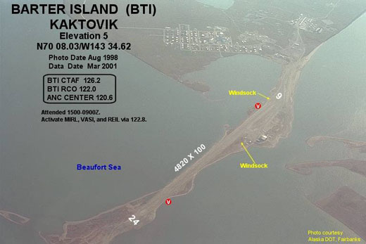
Runway Information
Runway 06/24
|
Dimension: |
4820 x 100 ft / 1469.1 x 30.5 m |
|
Surface: |
GRAVEL, |
|
Edge Lights: |
Medium |
|
|
Runway
06 |
Runway
24 |
|
Longitude: |
143-36-04.2970W |
143-33-45.1440W |
|
Latitude: |
70-08-03.5820N |
70-08-01.1350N |
|
Elevation: |
2.00 ft |
0.00 ft |
|
Alignment: |
93 |
127 |
|
Traffic Pattern: |
Left |
Left |
|
Markings: |
None, |
None, |
|
Crossing Height: |
38.00 ft |
30.00 ft |
|
VASI: |
4-box on left
side |
4-box on right
side |
|
Visual Glide Angle: |
3.00� |
3.00� |
|
Runway End Identifier: |
Yes |
Yes |
|
Centerline Lights: |
No |
No |
|
Touchdown Lights: |
No |
No |
|
Radio Navigation Aids
|
ID |
Type |
Name |
Ch |
Freq |
Var |
Dist |
|
BTI |
NDB |
Barter Island |
|
308.00 |
31E |
1.4 nm |
Remarks
-
(A89-1) FOR A TOLL FREE
CALL TO BARROW FSS CALL 1-800-779-7709.
-
RUNWAY NOT MONITORED.
RECOMMEND VISUAL INSPECTION PRIOR TO LANDING.
-
NOT REQUIRED UNDER FAR
157.
Operational Statistics
|
Aircraft
Operations: |
94/Week |
|
Air Taxi: |
51.5% |
|
General Aviation
Local: |
30.9% |
|
General Aviation
Itinerant: |
16.5% |
|
Military: |
1.0% |
Barter Island Lrrs Airport
Address: Upper
Yukon County, AK
Tel:907-852-0348
Images
and information placed above are from
http://www.airport-data.com/airport/BTI/
We
thank them for the data!
| General
Info |
| Country |
United
States |
| State |
ALASKA
|
| FAA ID |
BTI
|
| Latitude |
70-08-02.050N
|
| Longitude |
143-34-37.360W
|
| Elevation |
5 feet
|
| Near City |
BARTER
ISLAND LRRS |
We don't guarantee the information is fresh and accurate. The data may be wrong or outdated.
For more up-to-date information please refer to other sources.
|
|