|
|
| Atmautluak Airport |
 |
| IATA: ATT – ICAO: none – FAA LID: 4A2 |
| Summary |
| Airport type |
Public |
| Owner |
Alaska DOT&PF - Central Region |
| Serves |
Atmautluak, Alaska |
| Elevation AMSL |
17 ft / 5 m |
| Coordinates |
60°52′00″N 162°16′23″W / 60.8666667°N 162.27306°W / 60.8666667; -162.27306 |
| Runways |
| Direction |
Length |
Surface |
| ft |
m |
| 15/33 |
3,000 |
914 |
Gravel |
| Statistics |
| Enplanements (2007) |
2,613 |
| Source: FAA |
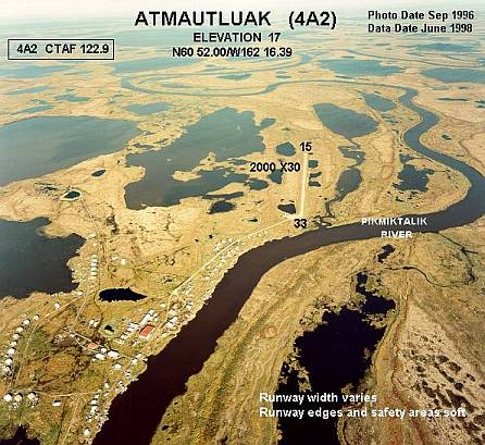
Atmautluak Airport (IATA: ATT, FAA LID: 4A2) is a state-owned public-use airport located in Atmautluak, in the Bethel Census Area of the U.S. state of Alaska.
As per Federal Aviation Administration records, this airport had 2,613 passenger boardings (enplanements) in calendar year 2007, an increase of 29% from the 2,018 enplanements in 2006. Facilities
Atmautluak Airport has one runway designated 15/33 with a 3,000 by 75 ft (914 x 23 m) gravel surface. The runway was previously 2,000 by 30 ft until it was expanded by the state.
Airlines
- Hageland Aviation Services
The above content comes from Wikipedia and is published under free licenses – click here to read more.
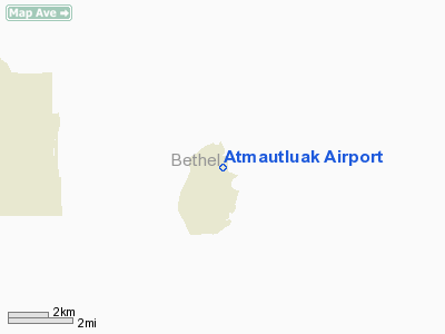
Atmautluak is a census-designated place
located in Bethel Census Area, Alaska. As of the 2000 census, the population
of the CDP is 294.
Atmautluak is located at 60°51'35"
North, 162°16'39" West (60.859675, -162.277616)GR1.
According to the United States Census Bureau, the CDP
has a total area of 8.7 km² (3.3 mi²). 1.7 km² (0.6 mi²)
of it is land and 7.0 km² (2.7 mi²) of it is water. The total
area is 81.19% water.
Location & QuickFacts
|
FAA
Information Effective: |
2005-10-27 |
|
Airport Identifier: |
4A2 |
|
Longitude/Latitude: |
162-16-23.3000W/60-52-00.2840N
-162.273139/60.866746 (Estimated) |
|
Elevation: |
17 ft / 5.18 m (Estimated) |
|
Land: |
0
acres |
|
From nearest city: |
0 nautical miles
SW of Atmautluak, AK |
|
Location: |
Bethel
County, AK |
|
Magnetic Variation: |
18E (1985) |
Owner & Manager
|
Ownership: |
Publicly
owned |
|
Owner: |
St Of Ak Dot/pf Central
Reg |
|
Address: |
Po
Box 196900
Anchorage, AK 99519-6900 |
|
Phone number: |
907-269-0747 |
|
Manager: |
L.j.
Davis |
|
Address: |
Po Box 505
Bethel, AK 99559 |
|
Phone number: |
907-543-2495 |
Airport Operations and Facilities
|
Airport
Use: |
Open
to public |
|
Wind indicator: |
Yes |
|
Segmented Circle: |
No |
|
Control Tower: |
No |
|
Attendance Schedule: |
UNATNDD |
|
Lighting Schedule: |
RDO-CTL
ACTVT MIRL RY 15/33 AND PAPIS & REILS RYS 15 &33 - CTAF. |
|
Landing fee charge: |
No |
|
Sectional chart: |
Bethel |
|
Region: |
AAL - Alaska |
|
Boundary ARTCC: |
ZAN
- Anchorage |
|
Tie-in FSS: |
ENA - Kenai |
|
FSS on Airport: |
No |
|
FSS Phone: |
800-478-3576 |
|
FSS Toll Free: |
1-800-WX-BRIEF |
|
NOTAMs Facility: |
BET (NOTAM-d service
avaliable) |
|
Federal Agreements: |
N |
Airport Communications
Airport Services
|
Airframe
Repair: |
NONE |
|
Power
Plant Repair: |
NONE |
|
Bottled Oxygen: |
NONE |
|
Bulk Oxygen: |
NONE |
Runway Information
Runway 15/33
|
Dimension: |
3000
x 75 ft / 914.4 x 22.9 m
HAS SOFT TUNDRA ON ALL SIDES SURROUNDING RY. |
|
Surface: |
GRAVEL, Poor Condition
FIRST 650 FT OF RY 33 ROUGH W/DIPS. |
|
Edge Lights: |
Medium |
|
|
Runway 15 |
Runway 33 |
|
Traffic Pattern: |
Left |
Left |
|
Crossing Height: |
25.00 ft |
24.00 ft |
|
VASI: |
4-light PAPI on left side |
4-light PAPI on left side |
|
Visual Glide Angle: |
3.00� |
3.00� |
|
Runway End Identifier: |
Yes |
Yes |
|
Obstruction: |
12 ft berm, 150.0 ft from runway, 12:1 slope to clear |
,
50:1 slope to clear
SAND PILES TO 30 FT, 300 FT L AND PARALLEL TO RY 33. 30 FT
POLE, 70 FT S, 150 FT L OF RY 33 THLD. |
|
Radio Navigation Aids
|
ID |
Type |
Name |
Ch |
Freq |
Var |
Dist |
|
OSE |
NDB |
Oscarville |
|
251.00 |
19E |
12.6
nm |
|
ET |
NDB |
Bethel |
|
344.00 |
19E |
13.9
nm |
|
BET |
VORTAC |
Bethel |
088X |
114.10 |
19E |
14.0
nm |
Remarks
-
CAUTION: RWY CONDITION
NOT MONITORED; RECOMMEND VISUAL INSPECTION PRIOR TO USING.
-
RY EDGES AND SAFETY AREAS
SOFT.
-
UPSLOPING TERRAIN AT
5% GRADE TO 20 FT ABOVE RUNWAY ELEVATION ON NW END OF RY 15/33.
-
15 FT BERM 150 FT OFF
END OF RY 15.
Atmautluak Airport
Address: Bethel
County, AK
Tel:
907-269-0747,
907-543-2495
Images
and information placed above are from
http://www.airport-data.com/airport/4A2/
http://en.wikipedia.org/wiki/Atmautluak%2C_Alaska
We thank them for the data!
| General Info
|
| Country |
United States
|
| State |
ALASKA
|
| FAA ID |
4A2
|
| Latitude |
60-52-00.284N
|
| Longitude |
162-16-23.300W
|
| Elevation |
17 feet
|
| Near City |
ATMAUTLUAK
|
We don't guarantee the information is fresh and accurate. The data may be wrong or outdated.
For more up-to-date information please refer to other sources.
|
|