|
|
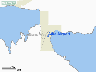
| Atka Airport |
 |
| IATA: AKB – ICAO: PAAK – FAA LID: AKA |
| Summary |
| Airport type |
Public |
| Owner |
Alaska DOT&PF - Central Region |
| Serves |
Atka, Alaska |
| Elevation AMSL |
56 ft / 17 m |
| Coordinates |
52°13′13″N 174°12′23″W / 52.22028°N 174.20639°W / 52.22028; -174.20639 |
| Runways |
| Direction |
Length |
Surface |
| ft |
m |
| 15/33 |
3,287 |
1,002 |
Asphalt |
| Statistics (2003) |
| Aircraft operations |
150 |
| Source: Federal Aviation Administration |
Atka Airport (IATA: AKB, ICAO: PAAK, FAA LID: AKA, formerly 40A) is a state-owned public-use airport located two nautical miles (3.7 km) north of the central business district of Atka, a city on Atka Island in the U.S. state of Alaska. Scheduled commercial airline service is subsidized by the Essential Air Service program.
Although most U.S. airports use the same three-letter location identifier for the FAA and IATA, this airport is assigned AKA by the FAA and AKB by the IATA. The airport's ICAO identifier is PAAK. Facilities and aircraft
Atka Airport has one asphalt paved runway designated 15/33 which measures 3,287 by 84 feet (1,002 x 26 m). For the 12-month period ending December 31, 2003, the airport had 150 aircraft operations, 100% of which were air taxi flights.
Airline and destination
- Peninsula Airways (Dutch Harbor/Unalaska)
The above content comes from Wikipedia and is published under free licenses – click here to read more.
Atka is a city located in Aleutians West Census Area,
Alaska. As of the 2000 census, the population of the city is 92.
The population of Atka is nearly entirely Aleut (Unangan).
The major industry is fishing.
Atka is located at 52°11'57"
North, 174°12'48" West (52.199271, -174.213398)GR1.
According to the U.S. Census Bureau, the city has a total
area of 93.7 km² (36.2 mi²). 22.6 km² (8.7 mi²) of
it is land and 71.0 km² (27.4 mi²) of it is water. The total
area is 75.81% water.
Location & QuickFacts
|
FAA
Information Effective: |
2005-10-27 |
|
Airport Identifier: |
AKA |
|
Longitude/Latitude: |
174-12-22.8610W/52-13-13.2540N
-174.206350/52.220348 (Estimated) |
|
Elevation: |
56 ft / 17.07 m (Surveyed) |
|
Land: |
0
acres |
|
From nearest city: |
2 nautical miles
N of Atka, AK |
|
Location: |
Unorganized
County, AK |
|
Magnetic Variation: |
08E (2005) |
Owner & Manager
|
Ownership: |
Publicly
owned |
|
Owner: |
St Of Ak Dot&pf-cen
Reg |
|
Address: |
Box
196900
Anchorage, AK 99519-6900 |
|
Phone number: |
907-269-0751 |
|
Manager: |
Steve
Berninger |
|
Address: |
Box 213
Unalaska, AK 99685 |
|
Phone number: |
907-581-1786 |
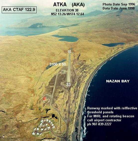
Airport Operations and Facilities
|
Airport
Use: |
Open
to public |
|
Wind indicator: |
Yes |
|
Segmented Circle: |
Yes |
|
Control Tower: |
No |
|
Attendance Schedule: |
UNATNDD |
|
Lighting Schedule: |
PHONE
REQ
FOR MIRL RY 15/33 & ROTATING BCN CALL ARPT CONTRACTOR 907-839-2227. |
|
Beacon Color: |
Clear-Green (lighted
land airport)
ROTG BCN OTS INDEFLY. |
|
Sectional chart: |
Anchorage |
|
Region: |
AAL - Alaska |
|
Boundary ARTCC: |
ZAN
- Anchorage |
|
Tie-in FSS: |
CDB - Cold Bay |
|
FSS Phone: |
907-532-2454 |
|
FSS Toll Free: |
1-800-478-7250 |
|
Alternate FSS: |
ENA
- Kenai |
|
Alt. FSS Toll Free: |
1-800-WX-BRIEF |
|
NOTAMs Facility: |
AKA
(NOTAM-d service avaliable) |
|
Federal Agreements: |
NGY |
Airport Communications
Runway
Information
Runway 15/33
|
Dimension: |
3287
x 84 ft / 1001.9 x 25.6 m |
|
Surface: |
ASPH,
Poor Condition
SPALLING PATCHES 3 FT BY 5 FT TO 8 FT BY 20 FT TO 1 IN DEPTH EITHER
SIDE OF CNTRLN FULL LENGTH OF RY. GRASS GROWING THROUGH CRACKS.
RWY 15 SAFETY AREA HAS 12 FT BY 30 FT DEPRESSION E. SIDE, STANDING
WATER AFTER RAIN. |
|
Weight Limit: |
Single wheel: 26000 lbs. |
|
Edge Lights: |
Medium |
|
|
Runway 15 |
Runway 33 |
|
Longitude: |
174-12-28.2010W |
174-12-17.5200W |
|
Latitude: |
52-13-29.1270N |
52-12-57.3810N |
|
Elevation: |
56.00 ft |
46.00 ft |
|
Alignment: |
127 |
127 |
|
Traffic Pattern: |
Left |
Left |
|
Markings: |
Basic, Fair Condition
/33 ALSO MKD WITH REFLECTIVE THR PANELS. |
Basic, Fair Condition |
|
Radio Navigation Aids
|
ID |
Type |
Name |
Ch |
Freq |
Var |
Dist |
Remarks
-
RWY COND NOT MONITORED;
RECOMMEND VISUAL INSPECTION PRIOR TO USING.
-
RWY 33 HAS 200 FT PAVED
SAFETY AREA; RWY 15 HAS 200 FT GRVL SAFETY AREA.
-
PILOTS ARE REQUESTED
TO SELF-ANNOUNCE ON CTAF PRIOR TO TAXIING ON RWY FOR DEPARTURE; LEAVING
THE RWY AND WITHIN 10 NM OF THE ARPT WHEN APPROACHING TO LAND.
-
FLOCKS OF GULLS AND EAGLES
COMMON ALONG THE SHORELINE OF NAZAN BAY YEAR-ROUND.
Operational Statistics
|
Aircraft
Operations: |
13/Month |
|
Air Taxi: |
100.0% |
Atka Airport
Address: Unorganized
County, AK
Tel:
907-269-0751,
907-581-1786
Images
and information placed above are from
http://www.airport-data.com/airport/AKA/
http://en.wikipedia.org/wiki/Atka%2C_Alaska
We
thank them for the data!
| General
Info |
| Country |
United
States |
| State |
ALASKA
|
| FAA ID |
AKA
|
| Latitude |
52-13-13.254N
|
| Longitude |
174-12-22.861W
|
| Elevation |
56 feet
|
| Near City |
ATKA
|
We don't guarantee the information is fresh and accurate. The data may be wrong or outdated.
For more up-to-date information please refer to other sources.
|
|