 |
|
Atqasuk Edward Burnell Memorial Airport |
| Atqasuk Edward Burnell Sr. Memorial Airport |
 |
| IATA: ATK – ICAO: PATQ – FAA LID: ATK |
| Summary |
| Airport type |
Public |
| Owner |
North Slope Borough |
| Location |
Atqasuk, Alaska |
| Elevation AMSL |
96 ft / 29 m |
| Coordinates |
70°28′02″N 157°26′09″W / 70.46722°N 157.43583°W / 70.46722; -157.43583 |
| Runways |
| Direction |
Length |
Surface |
| ft |
m |
| 6/24 |
4,370 |
1,332 |
Gravel |
| Statistics (2005) |
| Aircraft operations |
530 |
| Source: Federal Aviation Administration |
Atqasuk Edward Burnell Sr. Memorial Airport (IATA: ATK, ICAO: PATQ, FAA LID: ATK) is a public airport located one mile (1.6 km) south of the central business district (CBD) of Atqasuk, a city in North Slope Borough, Alaska, United States. The airport is owned by North Slope Borough. Facilities and aircraft
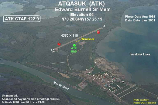
Atqasuk Edward Burnell Sr. Memorial Airport has one runway (6/24) with a gravel surface measuring 4,370 x 90 ft. (1,332 x 27 m). For 12-month period ending December 31, 2005, the airport had 530 aircraft operations: 94% air taxi and 6% general aviation.
Airlines and non-stop destinations
- Frontier Flying Service (Barrow, Wainwright)
- Hageland Aviation Services (Barrow, Wainwright)
The above content comes from Wikipedia and is published under free licenses – click here to read more.
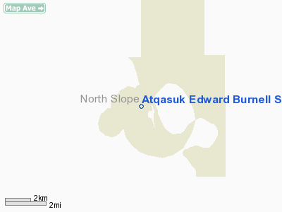
Atqasuk is a city located in North Slope Borough, Alaska.
As of the 2000 census, the population of the city is 228.
Atqasuk
is located at 70°28'40" North, 157°25'5" West (70.477663,
-157.418056)GR1.
According to the United
States Census Bureau, the city has a total area of 109.7 km² (42.3
mi²). 100.7 km² (38.9 mi²) of it is land and 9.0 km²
(3.5 mi²) of it is water. The total area is 8.22% water.
Location & QuickFacts
|
FAA
Information Effective: |
2005-10-27 |
|
Airport Identifier: |
ATK |
|
Longitude/Latitude: |
157-26-08.6500W/70-28-02.1940N
-157.435736/70.467276 (Estimated) |
|
Elevation: |
96 ft / 29.26 m (Estimated) |
|
Land: |
0
acres |
|
From nearest city: |
1 nautical miles
S of Atqasuk, AK |
|
Location: |
North
Slope County, AK |
|
Magnetic Variation: |
24E (1995) |
Owner & Manager
|
Ownership: |
Publicly
owned |
|
Owner: |
North Slope Borough |
|
Address: |
Box
69
Barrow, AK 99723 |
|
Phone number: |
907-852-2611 |
|
Manager: |
Eddie
Bodfish |
|
Address: |
Public Works
Atqasuk, AK |
|
Phone number: |
907-852-0348 |
Airport Operations and Facilities
|
Airport
Use: |
Open
to public |
|
Wind indicator: |
Yes |
|
Segmented Circle: |
Yes |
|
Control Tower: |
No |
|
Attendance Schedule: |
UNATNDD |
|
Lighting Schedule: |
24
HRS
ACTVT MIRL RY 06/24 & REIL RYS 06 & 24 - CTAF. |
|
Beacon Color: |
Clear-Green (lighted
land airport) |
|
Landing fee charge: |
No |
|
Sectional chart: |
Cape Lisburne |
|
Region: |
AAL
- Alaska |
|
Boundary ARTCC: |
ZAN - Anchorage |
|
Tie-in FSS: |
FAI
- Fairbanks |
|
FSS on Airport: |
No |
|
FSS Phone: |
907-474-0788 |
|
FSS Toll Free: |
1-866-248-6516
FOR A TOLL FREE CALL TO BARROW FSS CALL 1-800-779-7709. |
|
NOTAMs Facility: |
BRW
(NOTAM-d service avaliable) |
|
Federal Agreements: |
NGY |
Airport Communications
Airport Services
|
Airframe
Repair: |
NONE |
|
Power
Plant Repair: |
NONE |
|
Bottled Oxygen: |
NONE |
|
Bulk Oxygen: |
NONE |
Runway Information
Runway 06/24
|
Dimension: |
4370
x 90 ft / 1332.0 x 27.4 m
RY SURFACE 90 FT- 110 FT BETWEEN EDGE LIGHTS |
|
Surface: |
GRAVEL, Good Condition |
|
Edge Lights: |
Medium |
|
|
Runway 06 |
Runway 24 |
|
Longitude: |
157-27-11.8200W |
157-25-04.9500W |
|
Latitude: |
70-27-58.2500N |
70-28-04.9600N |
|
Elevation: |
96.00 ft |
94.00 ft |
|
Alignment: |
81 |
127 |
|
Traffic Pattern: |
Left |
Left |
|
Crossing Height: |
30.00 ft |
30.00 ft |
|
VASI: |
2-light PAPI on left side |
2-light PAPI on left side |
|
Visual Glide Angle: |
3.00� |
3.00� |
|
Runway End Identifier: |
Yes |
Yes |
|
Radio Navigation Aids
|
ID |
Type |
Name |
Ch |
Freq |
Var |
Dist |
|
ATK |
NDB |
Atqasuk |
|
350.00 |
24E |
0.2
nm |
Remarks
-
ABND RWY N SIDE OF COMMUNITY
VSBL.
-
RY CONDITION NOT MONITORED;
RECOMMEND VISUAL INSPECTION PRIOR TO USING.
-
ESTABD PRIOR TO 1959.
Operational Statistics
|
Aircraft
Operations: |
11/Week |
|
Air Taxi: |
94.3% |
|
General Aviation
Itinerant: |
5.7% |
Atqasuk Edward Burnell Sr Memorial Airport
Address: North
Slope County, AK
Tel:
907-852-2611,
907-852-0348
Images
and information placed above are from
http://www.airport-data.com/airport/ATK/
http://en.wikipedia.org/wiki/Atqasuk%2C_Alaska
We thank them for the data!
| General
Info |
| Country |
United
States |
| State |
ALASKA
|
| FAA ID |
ATK
|
| Latitude |
70-28-02.194N
|
| Longitude |
157-26-08.650W
|
| Elevation |
96 feet
|
| Near City |
ATQASUK
|
We don't guarantee the information is fresh and accurate. The data may be wrong or outdated.
For more up-to-date information please refer to other sources.
|
|


