|
|
| Annette Island Airport |
 |
| IATA: ANN – ICAO: PANT – FAA LID: ANN |
| Summary |
| Airport type |
Private |
| Owner |
Metlakatla Indian Comm. |
| Serves |
Metlakatla, Alaska |
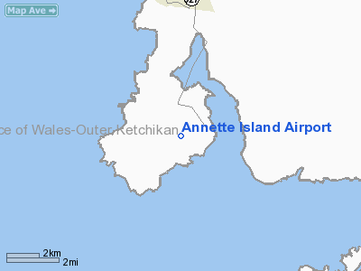
| Location |
Annette Island |
| Elevation AMSL |
119 ft / 36 m |
| Coordinates |
55°02′33″N 131°34′20″W / 55.0425°N 131.57222°W / 55.0425; -131.57222 |
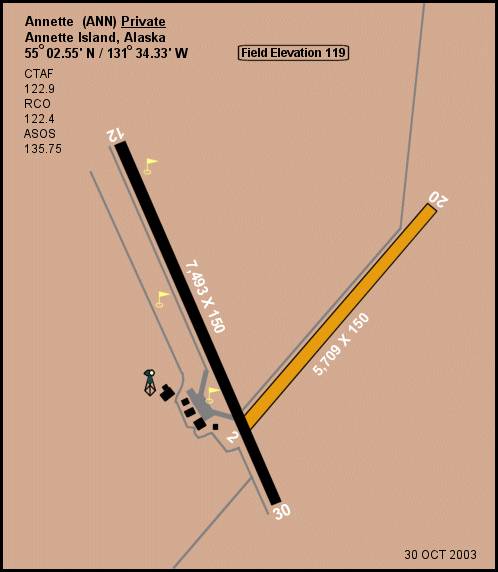
| Runways |
| Direction |
Length |
Surface |
| ft |
m |
| 12/30 |
7,493 |
2,284 |
Asphalt |
| 2/20 |
5,709 |
1,740 |
Gravel |
| Statistics (1990) |
| Aircraft operations |
8,400 |
| Source: Federal Aviation Administration |
Annette Island Airport (IATA: ANN, ICAO: PANT, FAA LID: ANN) is located on Annette Island in the Prince of Wales – Hyder Census Area of the U.S. state of Alaska. The airport is privately owned by the Metlakatla Indian Comm. It is located 5 nautical miles (9 km) south of Metlakatla, Alaska.
Facilities and aircraft
Annette Island Airport has two runways: 12/30 is 7,493 by 150 feet (2,284 x 46 m) with an asphalt surface and 2/20 is 5,709 by 150 feet (1,740 x 46 m) with a gravel surface. For the 12-month period ending January 16, 1990, the airport had 8,400 aircraft operations, an average of 23 per day: 64% general aviation, 24% military, and 12% air taxi.
The above content comes from Wikipedia and is published under free licenses – click here to read more.
Annette Island is an island in Gravina Islands of the
Alexander Archipelago of the Pacific Ocean on the southeastern coast of
Alaska. It is at 55°08'N 131°27'W. It is about 18 km (12 miles)
long and about 18 km (12 miles) wide. Annette Island is located across
the Revillagigedo Channel from the Alaska mainland on the east and across
from Revillagigedo Island on the north.
The largest settlement
on the island is Metlakatla. The island is the location of the only Indian
Reservation in Alaska.
Location & QuickFacts
|
FAA
Information Effective: |
2005-10-27 |
|
Airport Identifier: |
ANN |
|
Longitude/Latitude: |
131-34-20.0350W/55-02-32.7740N
-131.572232/55.042437 (Estimated) |
|
Elevation: |
119 ft / 36.27 m
(Surveyed) |
|
Land: |
0
acres |
|
From nearest city: |
0 nautical miles
N of Annette, AK |
|
Location: |
Ketchikan
County, AK |
|
Magnetic Variation: |
26E (1985) |
Owner & Manager
|
Ownership: |
Privately
owned |
|
Owner: |
Metlakatla Indian
Comm |
|
Address: |
Po Box 8
Metlakatla, AK 99926 |
|
Phone number: |
907-886-4441 |
|
Manager: |
Mayor Harris L Atkinson |
|
Address: |
Po Box 8
Metlakatla, AK 99926 |
Airport Operations and Facilities
|
Airport
Use: |
Private |
|
Segmented Circle: |
No |
|
Control Tower: |
No |
|
Attendance Schedule: |
UNATNDD |
|
Landing fee charge: |
No |
|
Sectional chart: |
Ketchikan |
|
Region: |
AAL
- Alaska |
|
Boundary ARTCC: |
ZAN - Anchorage |
|
Tie-in FSS: |
KTN
- Ketchikan |
|
FSS on Airport: |
No |
|
FSS Phone: |
907-225-9481 |
|
FSS Toll Free: |
LC225-9481 |
|
NOTAMs Facility: |
ANN |
Airport Communications
Airport Services
|
Bottled Oxygen: |
NONE |
|
Bulk Oxygen: |
NONE |
Runway Information
Runway 02/20
|
Dimension: |
5709
x 150 ft / 1740.1 x 45.7 m |
|
Surface: |
GRAVEL, |
|
|
Runway 02 |
Runway 20 |
|
Elevation: |
93.00 ft |
94.00 ft |
|
Traffic Pattern: |
Right |
Left |
|
Runway End Identifier: |
No |
No |
|
Centerline Lights: |
No |
No |
|
Touchdown Lights: |
No |
No |
|
Runway 12/30
|
Dimension: |
7493
x 150 ft / 2283.9 x 45.7 m |
|
Surface: |
ASPH,
|
|
|
Runway 12 |
Runway 30 |
|
Elevation: |
119.00 ft |
85.00 ft |
|
Traffic Pattern: |
Right |
Left |
|
Markings: |
Non-precision instrument, Good Condition |
Non-precision instrument, Good Condition |
|
Runway End Identifier: |
No |
No |
|
Centerline Lights: |
No |
No |
|
Touchdown Lights: |
No |
No |
|
Radio Navigation Aids
|
ID |
Type |
Name |
Ch |
Freq |
Var |
Dist |
|
ICK |
NDB |
Nichols |
|
266.00 |
27E |
2.0
nm |
|
CMJ |
NDB |
Clam
Cove |
|
396.00 |
27E |
18.7
nm |
|
ANN |
VORTAC |
Annette Island |
118X |
117.10 |
27E |
1.1
nm |
|
ECH |
VOT |
Ketchikan |
|
111.00 |
|
19.0
nm |
Remarks
-
MTNS NE; RWYS NOT MAINTAINED
NO SNOW REMOVAL.
-
FOR EMERG CALL 886-4868
(MAYORS OFFICE) TO ACTIVATE EMERG RESCUE TEAM.
-
VEHICULAR TRAFFIC ON
BOTH RWYS BROKEN GLASS ROCKS AND DEBRIS ON RWYS.
-
SOFT SPOTS IN PAVEMENT
RWY 12/30 AT 1600' & 2400' FM RWY 12 THR.
-
PPR - CALL 907-886-4868
DURING BUSINESS HRS.
Operational Statistics
|
Aircraft
Operations: |
162/Week |
|
Air Taxi: |
11.9% |
|
General Aviation
Local: |
4.8% |
|
General Aviation
Itinerant: |
59.5% |
|
Military: |
23.8% |
Annette Island Airport
Address: Ketchikan
County, AK
Tel:
907-886-4441
Images
and information placed above are from
http://www.airport-data.com/airport/ANN/
http://en.wikipedia.org/wiki/Annette_Island_%28Alaska%29
We thank them for the data!
| General
Info |
| Country |
United
States |
| State |
ALASKA
|
| FAA ID |
ANN
|
| Latitude |
55-02-32.774N
|
| Longitude |
131-34-20.035W
|
| Elevation |
119 feet
|
| Near City |
ANNETTE
|
We don't guarantee the information is fresh and accurate. The data may be wrong or outdated.
For more up-to-date information please refer to other sources.
|
|