 |
|
| Aniak Airport |
 |
| IATA: ANI – ICAO: PANI – FAA LID: ANI |
| Summary |
| Airport type |
Public |
| Owner |
State of Alaska DOT&PF - Central Region |
| Location |
Aniak, Alaska |
| Elevation AMSL |
88 ft / 27 m |
| Coordinates |
61°34′54″N 159°32′35″W / 61.58167°N 159.54306°W / 61.58167; -159.54306 |
| Runways |
| Direction |
Length |
Surface |
| ft |
m |
| 5W/23W |
3,000 |
914 |
Water |
| 10/28 |
6,000 |
1,829 |
Asphalt |
| Source: Federal Aviation Administration |
Aniak Airport (IATA: ANI, ICAO: PANI, FAA LID: ANI) is a public-use airport located on the Kuskokwim River in Aniak, a city in the Bethel Census Area of the U.S. state of Alaska. The airport is owned by the state. Facilities
Aniak Airport covers 1,722 acres (697 ha) and has one runway and one seaplane landing area:
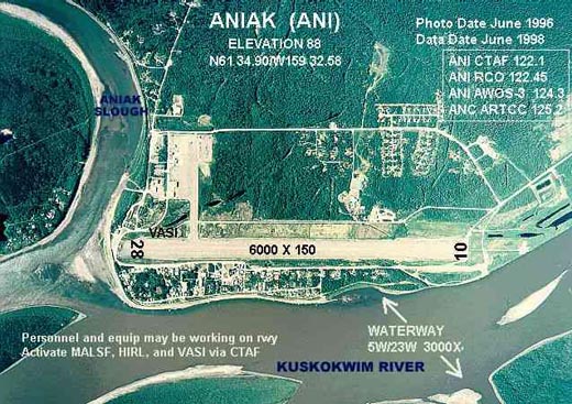
- Runway 10/28: 6,000 x 150 ft. (1,829 x 46 m), Surface: Asphalt
- Runway 5W/23W: 3,000 x 400 ft. (914 x 122 m), Surface: Water
Airlines and non-stop destinations
- Era Aviation (Anchorage)
- Frontier Flying Service (Anchorage, (By Era Aviation) Holy Cross, Kalskag, St. Mary's, Shageluk)
- Hageland Aviation Services (Chuathbaluk, Holy Cross, Kalskag)
- PenAir (Anchorage)
The above content comes from Wikipedia and is published under free licenses – click here to read more.
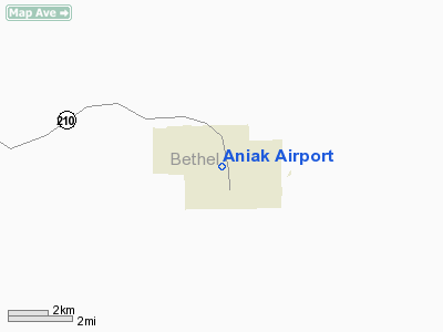
Aniak is located at 61°34'44" North, 159°33'1"
West (61.578821, -159.550255)GR1.
Aniak
is on the south bank of the Kuskokwim River at the head of Aniak Slough.
It is 95 km (59 miles) southwest of Russian Mission in the Yukon - Kuskokwim
Delta. Aniak is 148 km (92 miles) by air northeast of Bethel.
According to the United
States Census Bureau, the city has a total area of 22.8 km² (8.8
mi²). 16.9 km² (6.5 mi²) of it is land and 5.9 km²
(2.3 mi²) of it is water. The total area is 25.82% water.
History
Aniak
was the Yupik name for the area around present-day Aniak.
The word means "the place where it comes out" that is, where
the Aniak River flows into the Kuskokwim River.
In 1914, Tom L. Johnson homesteaded
the site of a long-abandonded Yupik village in the Aniak area and opened
a store and post office there. The Yupiks Willie Pete and Sam Simeon brought
their families from Ohagamiut to Aniak. A trader named Semen Lukin is
credited with the discovery of gold near Aniak in 1932.
Aniak
today is the commercial center for the area around it. Many of its residents
are fishermen.
Location & QuickFacts
|
FAA
Information Effective: |
2005-10-27 |
|
Airport Identifier: |
ANI |
|
Longitude/Latitude: |
159-32-34.9540W/61-34-53.7490N
-159.543043/61.581597 (Estimated) |
|
Elevation: |
88 ft / 26.82 m (Surveyed) |
|
Land: |
1722
acres |
|
From nearest city: |
0 nautical miles
S of Aniak, AK |
|
Location: |
Kuskokwim
County, AK |
|
Magnetic Variation: |
18E (1985) |
Owner & Manager
|
Ownership: |
Publicly
owned |
|
Owner: |
State Of Ak Ootpf-central
Rgn |
|
Address: |
Pouch
196900
Anchorage, AK 99519-6900 |
|
Phone number: |
907-266-1450 |
|
Manager: |
Terry
Hoffman |
|
Address: |
Box 73
Aniak, AK 99557 |
|
Phone number: |
907-675-4345 |
Airport Operations and Facilities
|
Airport
Use: |
Open
to public |
|
Wind indicator: |
Yes |
|
Segmented Circle: |
Yes |
|
Control Tower: |
No |
|
Attendance Schedule: |
ALL/MON-SAT/0800-1600 |
|
Lighting Schedule: |
DUSK-DAWN
ACTVT MALSF RY 10 & VASI RY 28 & HIRL RY 10/28 - CTAF. |
|
Beacon Color: |
Clear-Green (lighted
land airport) |
|
Landing fee charge: |
No |
|
Sectional chart: |
Mc Grath |
|
Region: |
AAL
- Alaska |
|
Boundary ARTCC: |
ZAN - Anchorage |
|
Tie-in FSS: |
ENA
- Kenai |
|
FSS on Airport: |
No |
|
FSS Phone: |
800-478-3576 |
|
FSS Toll Free: |
1-800-WX-BRIEF |
|
NOTAMs Facility: |
ANI
(NOTAM-d service avaliable) |
|
Federal Agreements: |
NRGPY |
Airport Communications
Airport Services
|
Fuel
available: |
100LLA |
|
Airframe
Repair: |
MINOR |
Runway Information
Runway 05W/23W
|
Dimension: |
3000
x 400 ft / 914.4 x 121.9 m |
|
Surface: |
WATER,
|
|
|
Runway 05W |
Runway 23W |
|
Traffic Pattern: |
Left |
Left |
|
Runway 10/28
|
Dimension: |
6000
x 150 ft / 1828.8 x 45.7 m |
|
Surface: |
ASPH,
Good Condition |
|
Edge Lights: |
High |
|
|
Runway 10 |
Runway 28 |
|
Longitude: |
159-33-27.9760W |
159-31-41.9430W |
|
Latitude: |
61-35-09.0450N |
61-34-38.4480N |
|
Elevation: |
88.00 ft |
88.00 ft |
|
Alignment: |
121 |
127 |
|
ILS Type: |
ILS/DME |
|
|
Traffic Pattern: |
Left |
Left |
|
Markings: |
Precision instrument, Good Condition |
Non-precision instrument, Good Condition |
|
Crossing Height: |
0.00 ft |
52.00 ft |
|
VASI: |
|
4-box on left side |
|
Visual Glide Angle: |
0.00� |
3.00� |
|
Approach lights: |
MALSF |
|
|
Radio Navigation Aids
|
ID |
Type |
Name |
Ch |
Freq |
Var |
Dist |
|
ANI |
NDB |
Aniak |
|
359.00 |
18E |
1.7
nm |
Remarks
-
SEAPLANE OPERATE IN ANIAK
SLOUGH AND RIVER IN FRONT OF TOWN.
-
ARPT CLSD TO ACFT OPNS
WHICH ARE REQUIRED TO CONDUCT PSGR SCREENING.
-
PERSONNEL AND EQUIPMENT
MAY BE WORKING ON THE RY AT ANY TIME.
-
ARPT CLSD TO PSGR ACFT
CERTIFIED FOR MORE THAN 30 PSGR SEATS.
-
PILOTS ARE REQUESTED
TO SELF-ANNOUNCE ON CTAF PRIOR TO TAXIING ON RWY FOR DEPARTURE; LEAVING
THE RWY AND WITHIN 10 NM OF THE ARPT WHEN APPROACHING TO LAND.
-
AIRPORT HAS DESIGNATED
TRANSIENT AIRCRAFT PARKING AVAILABLE. TRANSIENT AIRCRAFT PARKING IS
DESIGNATED WITH GREEN CONES.
Based Aircraft
|
Aircraft
based on field: |
30 |
|
Single Engine Airplanes: |
26 |
|
Multi Engine Airplanes: |
4 |
Operational Statistics
|
Aircraft
Operations: |
260/Week |
|
Air Taxi: |
48.1% |
|
General Aviation
Local: |
7.4% |
|
General Aviation
Itinerant: |
44.4% |
|
Military: |
0.1% |
Aniak Airport
Address: Kuskokwim
County, AK
Tel:
907-266-1450,
907-675-4345
Images
and information placed above are from
http://www.airport-data.com/airport/ANI/
http://en.wikipedia.org/wiki/Aniak%2C_Alaska
We thank them for the data!
| General
Info |
| Country |
United
States |
| State |
ALASKA
|
| FAA ID |
ANI
|
| Latitude |
61-34-53.749N
|
| Longitude |
159-32-34.954W
|
| Elevation |
88 feet
|
| Near City |
ANIAK
|
We don't guarantee the information is fresh and accurate. The data may be wrong or outdated.
For more up-to-date information please refer to other sources.
|
|


