|
 |
|
||||
|
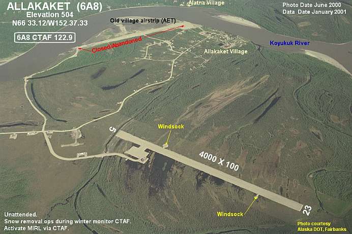
Allakaket Airport (IATA: AET, ICAO: PFAL, FAA LID: 6A8), is a state-owned public-use airport located two nautical miles (4 km) north-northwest of the central business district of Allakaket, a city in the Yukon-Koyukuk Census Area of the U.S. state of Alaska. The airport is sometimes referred to as the New Allakaket Airport because it was constructed on a site southeast of the original airport which is now closed. As per Federal Aviation Administration records, this airport had 2,505 passenger boardings (enplanements) in calendar year 2007, an increase of 27% from the 1,969 enplanements in 2006. Facilities and aircraftAllakaket Airport has one runway designated 5/23 with a gravel surface measuring 4,000 by 100 feet (1,219 x 30 m). For the 12-month period ending December 31, 2005, the airport had 2,270 aircraft operations, an average of 189 per month: 53% air taxi, 46% general aviation and 1% military. Airlines and destinations
The above content comes from Wikipedia and is published under free licenses – click here to read more.
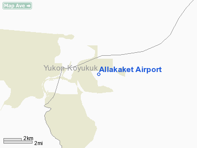
Allakaket is located at 66.562610° North, -152.64756° West (Sec. 14, T020N, R024W, Fairbanks Meridian.) Allakaket is located in the Fairbanks Recording District. Allakaket is on the south bank of the Koyukuk River, southwest of its junction with the Alatna River, approximately 190 air miles northwest of Fairbanks and 57 miles upriver from Hughes. The village of Alatna is located directly across the river. The area experiences a cold, continental climate with extreme temperature differences. The average high temperature during July is 70 degrees Fahrenheit. The average low temperature during January is well below zero and extended periods of -40 degrees Fahrenheit are common. The highest temperature ever recorded was 94 degrees Fahrenheit and the lowest was -75 degrees Fahrenheit. Average precipitation is 13 inches and annual snowfall is 72 inches. The Koyukuk River is ice-free from June through October. History, Culture and Demographics Several Native groups have lived in the area, including Koyukon Athabascans and Kobuk, Selawik, and Nunamiut Eskimos from the north and northwest. The Koyukon lived in several camps throughout the year, moving as the seasons changed, following the wild game and fish. The various bands established joint settlements after 1851. The old site of Alatna was a traditional trading center for Athabascans and Eskimos. The first mission on the Koyukuk River, St. John's-in-the-Wilderness Episcopal Mission, was established in 1906. A post office was opened in 1925. In 1938, the name of the community was changed to Allakaket (the old name for the mission), and the name Alatna was assumed by the small Eskimo community across the river. The first public school was established in 1957. A flood caused by ice jamming inundated 85% of the community in the Spring of 1964. In 1975, the community incorporated as a City, including both settlements of Allakaket and Alatna. A clinic and airport were built in 1978. A new school and community roads were built in 1979. In September 1994, flood waters destroyed and swept away nearly all of the community's buildings, homes, and food caches for the winter. Residents rebuilt near the old City site, but some new homes and facilities are now located outside of the incorporated City boundaries. New Allakaket and Alatna are located outside of the City limits. A federally-recognized tribe is located in the community -- the Allakaket Village. The population of the community consists of 95.9% Alaska Native or part Native. Allakaket is mainly an Athabascan community; Kobuk Eskimos live across the river in Alatna. Two separate village councils exist. Traditional potlatches, dances and foot races attract visitors from area villages. Subsistence activities provide the majority of food sources. Sale, importation, and possession of alcohol are banned in the village. During the 2000 U.S. Census, total housing units numbered 59, and vacant housing units numbered 18. Vacant housing units used only seasonally numbered 11. U.S. Census data for Year 2000 showed 28 residents as employed. The unemployment rate at that time was 39.13 percent, although 61.11 percent of all adults were not in the work force. The median household income was $16,563, per capita income was $10,912, and 12.9 percent of residents were living below the poverty level. Location & QuickFacts
Owner & Manager
Airport Operations and Facilities
Airport Communications
Runway InformationRunway 05/23
Radio Navigation Aids
Remarks
Operational Statistics
Address: Yukon-koyukuk County, AK Tel: 907-451-5217 Images
and information placed above are from We thank them for the data!
We don't guarantee the information is fresh and accurate. The data may be wrong or outdated. For more up-to-date information please refer to other sources. |
||||||||||||||||||||||||||||||||||||||||||||||||||||||||||||||||||||||||||||||||||||||||||||||||||||||||||||||||||||||||||||||||||||||||||||||||||||||||||||||||||||||||||||||||||||||||||||||||||||||||||||||||||||||||||||||||||||||||||||||||||||||||||

 |
|
Copyright 2004-2026 © by Airports-Worldwide.com, Vyshenskoho st. 36, Lviv 79010, Ukraine Legal Disclaimer |