|
 |
|
||||
|
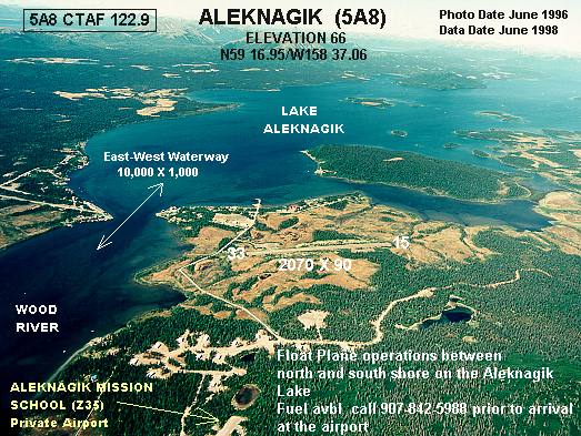
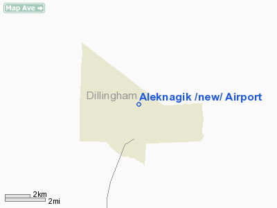
Aleknagik Airport (IATA: WKK, FAA LID: 5A8), also known as Aleknagik (New) Airport, is a state-owned, public-use airport located one nautical mile (1.85 km) east of the central business district of Aleknagik, a city in the Dillingham Census Area of the U.S. state of Alaska. This airport is included in the FAA's National Plan of Integrated Airport Systems for 2009–2013, which categorizes it as a general aviation facility. The airport formerly had scheduled service provided by PenAir with flights to Dillingham. It has a single runway and an FAA location identifier of 5A8, while Aleknagik Seaplane Base uses an FAA identifier of Z33. Facilities and aircraftAleknagik Airport covers an area of 51 acres (21 ha) at an elevation of 66 feet (20 m) above mean sea level. It has one runway designated 15/33 with a gravel and dirt surface measuring 2,040 by 80 feet (622 x 24 m). For the 12-month period ending December 31, 2008, the airport had 2,500 aircraft operations, an average of 208 per month: 60% air taxi and 40% general aviation. The above content comes from Wikipedia and is published under free licenses – click here to read more.
Aleknagik is located at the head of Wood River on the southeast end of Lake Aleknagik, 16 miles northwest of Dillingham. Aleknagik is named after Aleknagik Lake. Aleknagik means "wrong way home" in Yupik. Yupiks returning to their homes along the Nushagak River would sometimes become lost in the fog and find themselves swept up the Wood River to Aleknagik Lake by the tide. History, Culture and Demographics Wood River and Aleknagik Lake have been used historically as summer fish camps. Aleknagik means "Wrong Way Home," because Natives returning to their homes along the Nushagak River would sometimes become lost in the fog and find themselves swept up the Wood River with the tide, inadvertently arriving at Aleknagik Lake. The 1929 U.S. Census found 55 people living in the "Wood River village" area to the south. During 1930, there were five families living on the shores of the lake year-round, the Waskeys. Polleys, Hansons, Yakos, and Smiths. A log cabin territorial school was built on the south shore of the lake in 1933, and Josie Waskey was the first teacher. Attracted by the school, other facilities, and plentiful fish, game and timber, a number of families from Goodnews, Togiak, and Kulukak area relocated to Aleknagik. A post office was established in 1937. A two-story framed school with a teacher apartment was constructed in 1938. By 1939, Aleknagik had 78 residents, over 30 buildings, and a small sawmill. In the late 1940s, a Seventh-Day Adventist Mission and School was established on the north shore. During the 1950s, a Moravian Church and a Russian Orthodox Church were built in Aleknagik and over 35 families lived along the lake. In 1959, the state constructed a 25-mile road connecting the south shore to Dillingham. The road was passable only during the summer months, until the late 1980s, when it was upgraded and maintained year-round. The City was incorporated in 1973. Over 24 additional square miles were annexed to the City in April 2000. In the late 1800s there were about 200 people in Aleknagik and the other Wood River villages. The 1918-1919 influenza epidemic killed most of the residents of the villages. The few survivors were moved out of the area. In the 1920s former residents of the area started drifting back to Aleknagik, and the village grew to about 40 people by 1931. A United States Post Office was opened in 1937 by Mable Smith. By 1940, Aleknagik had over 30 buildings, including a community school, church, and small sawmill. The decline of a Seventh-day Adventist colony across the lake from Aleknagik brought several new families to Aleknagik. In 1946, a territorial school was constructed near Aleknagik. During this period, a Moravian Church, a Russian Orthodox Church and a Seventh-day Adventist mission school were established in the community. In the 1960s, the State of Alaska constructed a 41 km (25 mile) road connecting Aleknagik to Dillingham. Location & QuickFacts
Owner & Manager
Airport Operations and Facilities
Airport Communications
Airport Services
Runway InformationRunway 15/33
Radio Navigation Aids
Remarks
Based Aircraft
Operational Statistics
Address: Bristol Bay County, AK Tel: 907-269-0747. 907-842-5511 Images
and information placed above are from We thank them for the data!
We don't guarantee the information is fresh and accurate. The data may be wrong or outdated. For more up-to-date information please refer to other sources. |
||||||||||||||||||||||||||||||||||||||||||||||||||||||||||||||||||||||||||||||||||||||||||||||||||||||||||||||||||||||||||||||||||||||||||||||||||||||||||||||||||||||||||||||||||||||||||||||||||||||||||||||||||||||||||

 |
|
Copyright 2004-2026 © by Airports-Worldwide.com, Vyshenskoho st. 36, Lviv 79010, Ukraine Legal Disclaimer |